Havange
Havange (German: Havingen) is a commune in the Moselle department in Grand Est in north-eastern France.
Havange | |
|---|---|
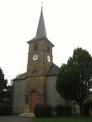 The Saint-Jean Baptiste Church | |
.svg.png.webp) Coat of arms | |
Location of Havange 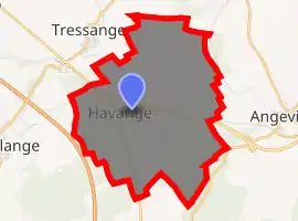
| |
 Havange  Havange | |
| Coordinates: 49°23′20″N 5°59′39″E | |
| Country | France |
| Region | Grand Est |
| Department | Moselle |
| Arrondissement | Thionville |
| Canton | Algrange |
| Intercommunality | CA Portes de France-Thionville |
| Government | |
| • Mayor (2020–2026) | Marc Ferrero |
| Area 1 | 9.65 km2 (3.73 sq mi) |
| Population (2017-01-01)[1] | 448 |
| • Density | 46/km2 (120/sq mi) |
| Time zone | UTC+01:00 (CET) |
| • Summer (DST) | UTC+02:00 (CEST) |
| INSEE/Postal code | 57305 /57650 |
| Elevation | 308–367 m (1,010–1,204 ft) (avg. 330 m or 1,080 ft) |
| 1 French Land Register data, which excludes lakes, ponds, glaciers > 1 km2 (0.386 sq mi or 247 acres) and river estuaries. | |
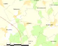
Havange is located between the communes of Tressange in the North, Rochonvillers in the Northeast, Angevillers in the East, Fontoy in the South and Boulange in the West. The village isn't really special compared to its neighbors. Its only historical monuments are the Saint Jean-Baptiste church and a casemate part of the Maginot Line located on the fields. But despite being in the countryside, the village is very well linked to the cities farther away as it is connected to the A30 autoroute to go to Metz, Southwestern Luxembourg or Belgium and located in the beginning of the D14 Dual carriageway to go to Thionville or Luxembourg (via the A31 autoroute), where most of the people work, go shopping or travel by air or train.
References
- "Populations légales 2017". INSEE. Retrieved 6 January 2020.
| Authority control |
|---|