Cartelègue
Cartelègue is a commune in the Gironde department in Nouvelle-Aquitaine in southwestern France.
Cartelègue | |
|---|---|
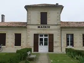 The town hall in Cartelègue | |
 Coat of arms | |
Location of Cartelègue 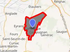
| |
 Cartelègue  Cartelègue | |
| Coordinates: 45°11′09″N 0°34′44″W | |
| Country | France |
| Region | Nouvelle-Aquitaine |
| Department | Gironde |
| Arrondissement | Blaye |
| Canton | L'Estuaire |
| Intercommunality | l'Estuaire |
| Government | |
| • Mayor (2008–2014) | Jean-Marie Le Goff |
| Area 1 | 11.45 km2 (4.42 sq mi) |
| Population (2017-01-01)[1] | 1,244 |
| • Density | 110/km2 (280/sq mi) |
| Time zone | UTC+01:00 (CET) |
| • Summer (DST) | UTC+02:00 (CEST) |
| INSEE/Postal code | 33101 /33390 |
| Elevation | 4–39 m (13–128 ft) (avg. 29 m or 95 ft) |
| 1 French Land Register data, which excludes lakes, ponds, glaciers > 1 km2 (0.386 sq mi or 247 acres) and river estuaries. | |
Population
| Year | Pop. | ±% |
|---|---|---|
| 1962 | 668 | — |
| 1968 | 747 | +11.8% |
| 1975 | 687 | −8.0% |
| 1982 | 1,064 | +54.9% |
| 1990 | 829 | −22.1% |
| 1999 | 874 | +5.4% |
| 2008 | 1,037 | +18.6% |
See also
References
- "Populations légales 2017". INSEE. Retrieved 6 January 2020.
| Wikimedia Commons has media related to Cartelègue. |
| Authority control |
|---|
This article is issued from Wikipedia. The text is licensed under Creative Commons - Attribution - Sharealike. Additional terms may apply for the media files.