Lège-Cap-Ferret
Lège-Cap-Ferret is a commune in the Gironde department in Nouvelle-Aquitaine in southwestern France. The commune stretches along the length of the Cap Ferret peninsula, from the village of Lège in the north to the point of Cap Ferret in the south.
Lège-Cap-Ferret | |
|---|---|
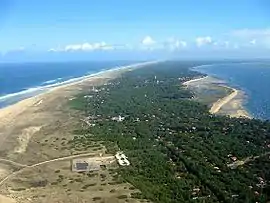 An aerial view of Cap-Ferret | |
.svg.png.webp) Coat of arms | |
Location of Lège-Cap-Ferret 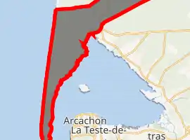
| |
 Lège-Cap-Ferret  Lège-Cap-Ferret | |
| Coordinates: 44°47′38″N 1°08′43″W | |
| Country | France |
| Region | Nouvelle-Aquitaine |
| Department | Gironde |
| Arrondissement | Arcachon |
| Canton | Andernos-les-Bains |
| Intercommunality | CA Bassin d'Arcachon Nord |
| Government | |
| • Mayor (2020–2026) | Philippe De Gonneville[1] |
| Area 1 | 93.62 km2 (36.15 sq mi) |
| Population (2017-01-01)[2] | 8,409 |
| • Density | 90/km2 (230/sq mi) |
| Time zone | UTC+01:00 (CET) |
| • Summer (DST) | UTC+02:00 (CEST) |
| INSEE/Postal code | 33236 /33950 |
| Elevation | 0–43 m (0–141 ft) (avg. 11 m or 36 ft) |
| 1 French Land Register data, which excludes lakes, ponds, glaciers > 1 km2 (0.386 sq mi or 247 acres) and river estuaries. | |
Population
| Year | Pop. | ±% |
|---|---|---|
| 1962 | 3,605 | — |
| 1968 | 4,232 | +17.4% |
| 1975 | 4,318 | +2.0% |
| 1982 | 4,981 | +15.4% |
| 1990 | 5,564 | +11.7% |
| 1999 | 6,307 | +13.4% |
| 2008 | 7,396 | +17.3% |
Climate
| Climate data for Lège-Cap-Ferret (1961–1990) | |||||||||||||
|---|---|---|---|---|---|---|---|---|---|---|---|---|---|
| Month | Jan | Feb | Mar | Apr | May | Jun | Jul | Aug | Sep | Oct | Nov | Dec | Year |
| Average high °C (°F) | 10.2 (50.4) |
11.6 (52.9) |
13.5 (56.3) |
15.9 (60.6) |
19.1 (66.4) |
22.0 (71.6) |
24.7 (76.5) |
24.5 (76.1) |
22.9 (73.2) |
19.1 (66.4) |
13.9 (57.0) |
10.8 (51.4) |
17.4 (63.3) |
| Daily mean °C (°F) | 7.3 (45.1) |
8.3 (46.9) |
9.8 (49.6) |
12.1 (53.8) |
15.1 (59.2) |
18.1 (64.6) |
20.5 (68.9) |
20.5 (68.9) |
18.7 (65.7) |
15.4 (59.7) |
10.6 (51.1) |
7.9 (46.2) |
13.7 (56.7) |
| Average low °C (°F) | 4.4 (39.9) |
5.1 (41.2) |
6.1 (43.0) |
8.2 (46.8) |
11.2 (52.2) |
14.1 (57.4) |
16.3 (61.3) |
16.4 (61.5) |
14.5 (58.1) |
11.6 (52.9) |
7.4 (45.3) |
5.0 (41.0) |
10.0 (50.0) |
| Average precipitation mm (inches) | 88.2 (3.47) |
75.1 (2.96) |
66.4 (2.61) |
64.7 (2.55) |
66.8 (2.63) |
47.1 (1.85) |
38.1 (1.50) |
53.0 (2.09) |
74.4 (2.93) |
83.2 (3.28) |
93.1 (3.67) |
95.5 (3.76) |
845.6 (33.29) |
| Average relative humidity (%) | 88 | 85 | 81 | 80 | 79 | 80 | 78 | 79 | 80 | 84 | 87 | 88 | 82.4 |
| Mean monthly sunshine hours | 90.8 | 113.2 | 171.4 | 201.0 | 233.7 | 258.4 | 287.2 | 260.0 | 212.5 | 170.6 | 109.6 | 88.1 | 2,196.5 |
| Source: Infoclimat.fr[3] | |||||||||||||
International relations
The commune is twinned with:
 Sandhausen, Germany, since 1980
 Úbeda, Spain, since 1983
References
- "Répertoire national des élus: les maires". data.gouv.fr, Plateforme ouverte des données publiques françaises (in French). 2 December 2020. Retrieved 7 December 2020.
- "Populations légales 2017". INSEE. Retrieved 6 January 2020.
- "Normes et records 1961-1990: Lège - Cap Ferret (33) - altitude 9m" (in French). Infoclimat. Retrieved December 28, 2015.
| Wikimedia Commons has media related to Lège-Cap-Ferret. |
| Authority control |
|---|
This article is issued from Wikipedia. The text is licensed under Creative Commons - Attribution - Sharealike. Additional terms may apply for the media files.