Saint-Denis-de-Pile
Saint-Denis-de-Pile is a commune in the Gironde department in Nouvelle-Aquitaine in southwestern France. It is situated approximately 9 kilometres (6 mi) north of Libourne on the eastern side of the Isle River.
Saint-Denis-de-Pile | |
|---|---|
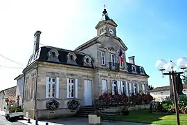 The town hall in Saint-Denis-de-Pile | |
Location of Saint-Denis-de-Pile 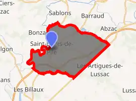
| |
 Saint-Denis-de-Pile  Saint-Denis-de-Pile | |
| Coordinates: 44°59′33″N 0°12′18″W | |
| Country | France |
| Region | Nouvelle-Aquitaine |
| Department | Gironde |
| Arrondissement | Libourne |
| Canton | Le Nord-Libournais |
| Intercommunality | CA du Libournais |
| Government | |
| • Mayor (2008–2014) | Alain Marois |
| Area 1 | 28.27 km2 (10.92 sq mi) |
| Population (2017-01-01)[1] | 5,535 |
| • Density | 200/km2 (510/sq mi) |
| Time zone | UTC+01:00 (CET) |
| • Summer (DST) | UTC+02:00 (CEST) |
| INSEE/Postal code | 33393 /33910 |
| Elevation | 2–49 m (6.6–160.8 ft) |
| 1 French Land Register data, which excludes lakes, ponds, glaciers > 1 km2 (0.386 sq mi or 247 acres) and river estuaries. | |
Geographie
The commune borders in the North and West are set by the Isle river. Saint-Denis-de-Pile borders the commune Sablons in the North, Abzac in the Northeast, Les Artigues-de-Lussac and Montagne in the Southeast, Lalande-de-Pomerol in the South, Savignac-d’Isle in the West und Bonzac in the Nortwesr.
Population
| Year | Pop. | ±% |
|---|---|---|
| 1906 | 2,506 | — |
| 1936 | 2,183 | −12.9% |
| 1954 | 2,172 | −0.5% |
| 1962 | 2,237 | +3.0% |
| 1968 | 2,371 | +6.0% |
| 1975 | 2,807 | +18.4% |
| 1999 | 4,080 | +45.4% |
| 2008 | 4,940 | +21.1% |
See also
References
- "Populations légales 2017". INSEE. Retrieved 6 January 2020.
| Wikimedia Commons has media related to Saint-Denis-de-Pile. |
| Authority control |
|---|
This article is issued from Wikipedia. The text is licensed under Creative Commons - Attribution - Sharealike. Additional terms may apply for the media files.