Chewton, Pennsylvania
Chewton is an unincorporated community and census-designated place (CDP) in Lawrence County, Pennsylvania, United States. The population was 488 at the 2010 census.[2]
Chewton, Pennsylvania | |
|---|---|
 Chewton Christian Church | |
 Chewton  Chewton | |
| Coordinates: 40°53′21″N 80°19′33″W | |
| Country | United States |
| State | Pennsylvania |
| County | Lawrence County |
| Township | Wayne |
| Area | |
| • Total | 1.51 sq mi (3.91 km2) |
| • Land | 1.49 sq mi (3.87 km2) |
| • Water | 0.02 sq mi (0.04 km2) |
| Elevation | 910 ft (280 m) |
| Population (2010)[2] | |
| • Total | 488 |
| • Density | 327/sq mi (126.1/km2) |
| Time zone | UTC-4 (EST) |
| • Summer (DST) | UTC-5 (EDT) |
| Area code(s) | 724 |
| FIPS code | 42-13408 |
| GNIS feature ID | 1171765 |
Geography
Chewton is located in southern Lawrence County at 40°53′21″N 80°19′33″W (40.8976, -80.3184),[3] in the northwest part of Wayne Township. It sits on a bluff overlooking the east bank of the Beaver River. It is bordered across the river by the borough of Wampum.
Chewton is 9 miles (14 km) south of New Castle, the county seat. Pennsylvania Route 288 passes through the southwest side of the community, leading west across the Beaver River into Wampum and southeast 4 miles (6 km) to Ellwood City.
According to the United States Census Bureau, the CDP has a total area of 1.5 square miles (3.9 km2), of which 0.02 square miles (0.04 km2), or 1.06%, are water.[1] Via the Beaver River, Chewton is part of the Ohio River watershed.
References
- "2019 U.S. Gazetteer Files: Places: Pennsylvania". United States Census Bureau. Retrieved October 6, 2020.
- "Total Population: 2010 Census DEC Summary File 1 (P1), Chewton CDP, Pennsylvania". data.census.gov. U.S. Census Bureau. Retrieved October 6, 2020.
- "US Gazetteer files: 2010, 2000, and 1990". United States Census Bureau. 2011-02-12. Retrieved 2011-04-23.
Municipalities and communities of Lawrence County, Pennsylvania, United States | ||
|---|---|---|
| City | 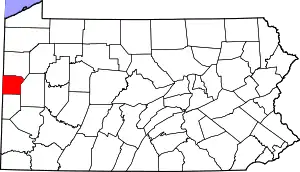 | |
| Boroughs | ||
| Townships | ||
| CDPs | ||
| Unincorporated communities | ||
| Footnotes | ‡This populated place also has portions in an adjacent county or counties | |
| ||
| Counties |  Map of the Pittsburgh Tri-State with green counties in the metropolitan area and yellow counties in the combined area | |
|---|---|---|
| Major cities | ||
| Cities and towns 15k–50k (in 2010) | ||
| Airports | ||
| Topics | ||
| ||