Wilmington Township, Lawrence County, Pennsylvania
Wilmington Township is a township in Lawrence County, Pennsylvania, United States. The population was 2,715 at the 2010 census.[5]
Wilmington Township | |
|---|---|
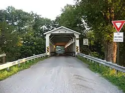 Banks Covered Bridge (1889) National Register of Historic Places | |
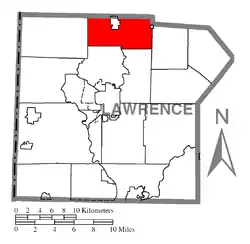 Location of Wilmington Township in Lawrence County | |
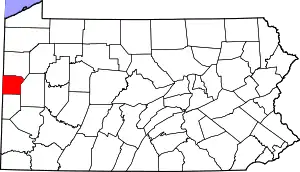 Location of Lawrence County in Pennsylvania | |
| Country | United States |
| State | Pennsylvania |
| County | Lawrence County |
| Established | 1798 |
| Area | |
| • Total | 19.91 sq mi (51.58 km2) |
| • Land | 19.73 sq mi (51.11 km2) |
| • Water | 0.18 sq mi (0.47 km2) |
| Highest elevation [2] (south of Shepard School) | 1,290 ft (390 m) |
| Lowest elevation | 885 ft (270 m) |
| Population (2010) | |
| • Total | 2,715 |
| • Estimate (2018)[3] | 2,577 |
| • Density | 133.39/sq mi (51.50/km2) |
| Time zone | UTC-4 (EST) |
| • Summer (DST) | UTC-5 (EDT) |
| Area code(s) | 724 |
| Historical population | |||
|---|---|---|---|
| Census | Pop. | %± | |
| 2000 | 2,760 | — | |
| 2010 | 2,715 | −1.6% | |
| 2018 (est.) | 2,577 | [3] | −5.1% |
| U.S. Decennial Census[4] | |||
Wilmington was established as a township in February 1846 by combining parts of Neshannock Township in Lawrence County with parts of Lackawannock Township in Mercer County. The borough of New Wilmington is an incorporated enclave within the township.
History
Banks Covered Bridge was listed on the National Register of Historic Places in 1980.[6]
Geography
According to the United States Census Bureau, the township has a total area of 20.0 square miles (51.9 km2), of which 20.0 square miles (51.9 km2) is land and 0.04 square miles (0.1 km2), or 0.10%, is water. Unincorporated communities in the township include Cottage Grove, Fayette, Mayville, and Neshannock Falls.
Demographics
As of the census[7] of 2000, there were 2,760 people, 949 households, and 755 families residing in the township. The population density was 137.8 people per square mile (53.2/km2). There were 991 housing units at an average density of 49.5/sq mi (19.1/km2). The racial makeup of the township was 99.20% White, 0.29% African American, 0.04% Native American, 0.04% Asian, 0.07% from other races, and 0.36% from two or more races. Hispanic or Latino of any race were 0.54% of the population.
There were 949 households, out of which 35.3% had children under the age of 18 living with them, 70.0% were married couples living together, 6.6% had a female householder with no husband present, and 20.4% were non-families. 18.2% of all households were made up of individuals, and 8.0% had someone living alone who was 65 years of age or older. The average household size was 2.91 and the average family size was 3.34.
In the township the population was spread out, with 30.5% under the age of 18, 7.9% from 18 to 24, 23.9% from 25 to 44, 24.1% from 45 to 64, and 13.5% who were 65 years of age or older. The median age was 37 years. For every 100 females, there were 94.2 males. For every 100 females age 18 and over, there were 95.8 males.
The median income for a household in the township was $40,179, and the median income for a family was $46,397. Males had a median income of $36,893 versus $26,719 for females. The per capita income for the township was $18,323. About 11.0% of families and 16.7% of the population were below the poverty line, including 28.1% of those under age 18 and 8.9% of those age 65 or over.
References
- "2016 U.S. Gazetteer Files". United States Census Bureau. Retrieved Aug 14, 2017.
- "Neshannock Falls Topo Map, Lawrence County PA (New Castle North Area)". TopoZone. Locality, LLC. Retrieved 5 September 2019.
- Bureau, U. S. Census. "U.S. Census website". United States Census Bureau. US Census Bureau. Retrieved 5 September 2019.
- "Census of Population and Housing". Census.gov. Retrieved June 4, 2016.
- "Profile of General Population and Housing Characteristics: 2010 Demographic Profile Data (DP-1): Wilmington township, Lawrence County, Pennsylvania". United States Census Bureau. Retrieved March 28, 2012.
- "National Register Information System". National Register of Historic Places. National Park Service. July 9, 2010.
- "U.S. Census website". United States Census Bureau. Retrieved 2008-01-31.
Municipalities and communities of Lawrence County, Pennsylvania, United States | ||
|---|---|---|
| City | | |
| Boroughs | ||
| Townships | ||
| CDPs | ||
| Unincorporated communities | ||
| Footnotes | ‡This populated place also has portions in an adjacent county or counties | |
| ||
| Counties |  Map of the Pittsburgh Tri-State with green counties in the metropolitan area and yellow counties in the combined area | |
|---|---|---|
| Major cities | ||
| Cities and towns 15k–50k (in 2010) | ||
| Airports | ||
| Topics | ||
| ||