Clark, New Jersey
Clark is a township in southern Union County, New Jersey, United States. As of the 2010 United States Census, the township's population was 14,756[9][10][11] reflecting an increase of 159 (+1.1%) from the 14,597 counted in the 2000 Census, which had in turn declined by 32 (-0.2%) from the 14,629 counted in the 1990 Census.[19]
Clark, New Jersey | |
|---|---|
| Township of Clark | |
| Motto(s): Growth, Industry, History[1] | |
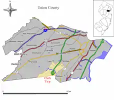 Map of Clark Township in Union County. Inset: Location of Union County in New Jersey. | |
 Census Bureau map of Clark, New Jersey | |
 Clark Location in Union County  Clark Location in New Jersey  Clark Location in the United States | |
| Coordinates: 40.618474°N 74.316°W[2][3] | |
| Country | |
| State | |
| County | |
| Incorporated | March 23, 1864 |
| Named for | Abraham Clark |
| Government | |
| • Type | Faulkner Act Mayor-Council |
| • Body | Township Council |
| • Mayor | Salvatore F. "Sal" Bonaccorso (R, term ends December 31, 2024)[5][6] |
| • Administrator | John Laezza[5] |
| • Municipal clerk | Edie Merkel[5] |
| Area | |
| • Total | 4.45 sq mi (11.53 km2) |
| • Land | 4.27 sq mi (11.07 km2) |
| • Water | 0.18 sq mi (0.47 km2) 4.04% |
| Area rank | 283rd of 565 in state 11th of 21 in county[2] |
| Elevation | 39 ft (12 m) |
| Population | |
| • Total | 14,756 |
| • Estimate (2019)[12] | 15,911 |
| • Rank | 170th of 566 in state 13th of 21 in county[13] |
| • Density | 3,430.5/sq mi (1,324.5/km2) |
| • Density rank | 188th of 566 in state 16th of 21 in county[13] |
| Time zone | UTC−05:00 (Eastern (EST)) |
| • Summer (DST) | UTC−04:00 (Eastern (EDT)) |
| ZIP Code | 07066[14] |
| Area code(s) | 732/848[15] |
| FIPS code | 3403913150[2][16][17] |
| GNIS feature ID | 0882216[18] |
| Website | www |
History

The territory that would become Clark was originally a part of several early villages. The Robinson Plantation House[20][21] and The Squire Hartshorne House, buildings from the late 17th century,[22] are remnants of the era. The Homestead Farm at Oak Ridge was the site of a skirmish preceding the Battle of Short Hills.[23] In 1858, after the City of Rahway was incorporated, the area of present-day Clark was designated as the 5th Ward of Rahway. Clark was incorporated as a township by an act of the New Jersey Legislature on March 23, 1864, from portions of Rahway.[24] The township was named for Abraham Clark, a signer of the Declaration of Independence.[25] Portions of the township were taken to form Cranford Township (March 14, 1871) and Winfield Township (August 6, 1941).[24]
New Jersey Monthly magazine ranked Clark as its 33rd best place to live in its 2008 rankings of the "Best Places To Live" in New Jersey.[26] In 2013, New Jersey Monthly magazine ranked Clark 174th in its rankings of "Best Places To Live" in New Jersey.[27]
Geography
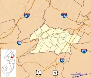
According to the United States Census Bureau, the township had a total area of 4.45 square miles (11.53 km2), including 4.27 square miles (11.07 km2) of land and 0.18 square miles (0.47 km2) of water (4.04%).[2][3]
Unincorporated communities, localities and place names located partially or completely within the township include Ashbrook, Florence Mills, Lenox, Madison Hill and Picton.[28]
The Rahway River Parkway along the Rahway River runs through the township.
The town borders Scotch Plains and Westfield on the west, Cranford and Winfield Park on the north, Linden and Rahway on the east, and Edison and Woodbridge Township in Middlesex County on the south.[29][30][31]
Demographics
| Historical population | |||
|---|---|---|---|
| Census | Pop. | %± | |
| 1870 | 331 | — | |
| 1880 | 353 | 6.6% | |
| 1890 | 367 | 4.0% | |
| 1900 | 374 | 1.9% | |
| 1910 | 469 | 25.4% | |
| 1920 | 794 | 69.3% | |
| 1930 | 1,474 | 85.6% | |
| 1940 | 2,083 | 41.3% | |
| 1950 | 4,352 | 108.9% | |
| 1960 | 12,195 | 180.2% | |
| 1970 | 18,829 | 54.4% | |
| 1980 | 16,699 | −11.3% | |
| 1990 | 14,629 | −12.4% | |
| 2000 | 14,597 | −0.2% | |
| 2010 | 14,756 | 1.1% | |
| 2019 (est.) | 15,911 | [12][32][33] | 7.8% |
| Population sources: 1870-1920[34] 1870[35][36] 1880-1890[37] 1890-1910[38] 1910-1930[39] 1930-1990[40] 2000[41][42] 2010[9][10][11] | |||
Census 2010
The 2010 United States Census counted 14,756 people, 5,562 households, and 4,038 families in the township. The population density was 3,430.5 per square mile (1,324.5/km2). There were 5,751 housing units at an average density of 1,337.0 per square mile (516.2/km2). The racial makeup was 93.29% (13,766) White, 0.84% (124) Black or African American, 0.10% (15) Native American, 3.71% (547) Asian, 0.03% (5) Pacific Islander, 1.15% (169) from other races, and 0.88% (130) from two or more races. Hispanic or Latino of any race were 7.50% (1,107) of the population.[9]
Of the 5,562 households, 30.2% had children under the age of 18; 60.4% were married couples living together; 9.0% had a female householder with no husband present and 27.4% were non-families. Of all households, 24.0% were made up of individuals and 12.0% had someone living alone who was 65 years of age or older. The average household size was 2.63 and the average family size was 3.15.[9]
21.2% of the population were under the age of 18, 7.1% from 18 to 24, 23.6% from 25 to 44, 29.6% from 45 to 64, and 18.5% who were 65 years of age or older. The median age was 43.8 years. For every 100 females, the population had 92.6 males. For every 100 females ages 18 and older there were 88.8 males.[9]
The Census Bureau's 2006-2010 American Community Survey showed that (in 2010 inflation-adjusted dollars) median household income was $80,959 (with a margin of error of +/- $7,674) and the median family income was $99,839 (+/- $7,789). Males had a median income of $65,399 (+/- $3,444) versus $49,649 (+/- $3,780) for females. The per capita income for the township was $37,288 (+/- $2,811). About 2.3% of families and 3.3% of the population were below the poverty line, including 3.3% of those under age 18 and 6.4% of those age 65 or over.[43]
According to the 2009-2013 American Community Survey, the largest ancestry groups were:[44]
Census 2000
As of the 2000 United States Census[16] there were 14,597 people, 5,637 households, and 4,126 families residing in the township. The population density was 3,359.6 people per square mile (1,298.6/km2). There were 5,709 housing units at an average density of 1,314.0 per square mile (507.9/km2). The racial makeup of the township was 95.61% White, 0.30% African American, 0.01% Native American, 2.75% Asian, 0.63% from other races, and 0.69% from two or more races. Also Hispanic or Latino of any race were 3.67% of the population.[41][42]
There were 5,637 households, out of which 28.1% had children under the age of 18 living with them, 61.4% were married couples living together, 9.0% had a female householder with no husband present, and 26.8% were non-families. 24.1% of all households were made up of individuals, and 12.9% had someone living alone who was 65 years of age or older. The average household size was 2.56 and the average family size was 3.07.[41][42]
In the township the population was spread out, with 20.8% under the age of 18, 5.4% from 18 to 24, 27.6% from 25 to 44, 24.5% from 45 to 64, and 21.7% who were 65 years of age or older. The median age was 43 years. For every 100 females, there were 90.5 males. For every 100 females age 18 and over, there were 86.4 males.[41][42]
The median income for a household in the township was $65,019, and the median income for a family was $77,291. Males had a median income of $54,543 versus $36,361 for females. The per capita income for the township was $29,883. About 1.0% of families and 1.7% of the population were below the poverty line, including 2.0% of those under age 18 and 2.7% of those age 65 or over.[41][42]
Government
Local government
Clark Township is governed within the Faulkner Act, formally known as the Optional Municipal Charter Law, under the Mayor-Council system of municipal government. The township is one of 71 municipalities (of the 565) statewide that use this form of government.[45] The Clark Township Committee is comprised of seven members, who are all chosen on a partisan basis in even-numbered years as part of the November general election. Three members are elected at-large from the township as a whole and four are elected from wards. The three Council-at-large seats and Mayor come up to vote together, and then the four ward seats are up for vote two years later.[4][46]
As of 2020, the Mayor of Clark is Republican Salvatore F. "Sal" Bonaccorso, whose term of office ends December 31, 2020. Members of the Township Council are Council President Patrick O'Connor (Second Ward; R, 2022), Council Vice President Steven M. Hund (Third Ward; R, 2022),Angel Albanese (at-large; R, 2020), Alvin Barr (at-large; R, 2020), Frank G. Mazzarella (First Ward; R, 2022), Bill Smith (at-large; R, 2020) and Brian P. Toal (Fourth Ward; R, 2022).[5][47][48][49][50]
Federal, state and county representation
Clark is located in New Jersey's 7th Congressional District,[51] and is part of New Jersey's 22nd state legislative district.[10][52][53]
For the 116th United States Congress. New Jersey's Seventh Congressional District is represented by Tom Malinowski (D, Ringoes).[54] New Jersey is represented in the United States Senate by Democrats Cory Booker (Newark, term ends 2021)[55] and Bob Menendez (Paramus, term ends 2025).[56][57]
For the 2020–2021 session (Senate, General Assembly), the 22nd Legislative District of the New Jersey Legislature is represented in the State Senate by Nicholas Scutari (D, Linden) and in the General Assembly by Linda Carter (D, Plainfield) and James J. Kennedy (D, Rahway).[58][59]
Union County is governed by a Board of Chosen Freeholders, whose nine members are elected at-large to three-year terms of office on a staggered basis with three seats coming up for election each year, with an appointed County Manager overseeing the day-to-day operations of the county. At an annual reorganization meeting held in the beginning of January, the board selects a Chair and Vice Chair from among its members.[60] As of 2019, Union County's Freeholders are Chair Bette Jane Kowalski (D, Cranford, term ends December 31, 2019),[61] Vice Chair Alexander Mirabella (D, Fanwood, 2021)[62] Angel G. Estrada (D, Elizabeth, 2020),[63] Angela R. Garretson (D, Hillside Township, 2020),[64] Sergio Granados (D, Elizabeth, 2019),[65] Christopher Hudak (D, Linden, term ends December 31, 2020),[66] Kimberly Palmieri-Mouded (D, Westfield, 2021),[67] Andrea Staten (D, Roselle, 2021),[68] and Rebecca Williams (D, Plainfield, 2019).[69] Constitutional officers elected on a countywide basis are County Clerk Joanne Rajoppi (D, Union, 2020),[70] Sheriff Peter Corvelli (D, Kenilworth, 2020)[71] and Surrogate James S. LaCorte (D, Springfield Township, 2019).[72] The County Manager is Edward Oatman.
Politics
As of March 23, 2011, there were a total of 10,190 registered voters in Clark Township, of which 2,841 (27.9% vs. 41.8% countywide) were registered as Democrats, 2,311 (22.7% vs. 15.3%) were registered as Republicans and 5,036 (49.4% vs. 42.9%) were registered as Unaffiliated. There were 2 voters registered to other parties.[73] Among the township's 2010 Census population, 69.1% (vs. 53.3% in Union County) were registered to vote, including 87.6% of those ages 18 and over (vs. 70.6% countywide).[73][74]
In the 2012 presidential election, Republican Mitt Romney received 4,538 votes (58.6% vs. 32.3% countywide), ahead of Democrat Barack Obama with 3,041 votes (39.3% vs. 66.0%) and other candidates with 97 votes (1.3% vs. 0.8%), among the 7,741 ballots cast by the township's 10,614 registered voters, for a turnout of 72.9% (vs. 68.8% in Union County).[75][76] In the 2008 presidential election, Republican John McCain received 5,093 votes (61.5% vs. 35.2% countywide), ahead of Democrat Barack Obama with 3,038 votes (36.7% vs. 63.1%) and other candidates with 85 votes (1.0% vs. 0.9%), among the 8,276 ballots cast by the township's 10,550 registered voters, for a turnout of 78.4% (vs. 74.7% in Union County).[77] In the 2004 presidential election, Republican George W. Bush received 4,819 votes (58.7% vs. 40.3% countywide), ahead of Democrat John Kerry with 3,237 votes (39.4% vs. 58.3%) and other candidates with 80 votes (1.0% vs. 0.7%), among the 8,209 ballots cast by the township's 10,493 registered voters, for a turnout of 78.2% (vs. 72.3% in the whole county).[78]
In the 2013 gubernatorial election, Republican Chris Christie received 67.4% of the vote (3,016 cast), ahead of Democrat Barbara Buono with 31.3% (1,402 votes), and other candidates with 1.3% (60 votes), among the 4,549 ballots cast by the township's 10,438 registered voters (71 ballots were spoiled), for a turnout of 43.6%.[79][80] In the 2009 gubernatorial election, Republican Chris Christie received 3,375 votes (63.4% vs. 41.7% countywide), ahead of Democrat Jon Corzine with 1,500 votes (28.2% vs. 50.6%), Independent Chris Daggett with 365 votes (6.9% vs. 5.9%) and other candidates with 40 votes (0.8% vs. 0.8%), among the 5,327 ballots cast by the township's 10,302 registered voters, yielding a 51.7% turnout (vs. 46.5% in the county).[81]
Education
The Clark Public School District serves students in pre-kindergarten through twelfth grade.[82] As of the 2017–18 school year, the district, comprised of five schools, had an enrollment of 2,328 students and 179.5 classroom teachers (on an FTE basis), for a student–teacher ratio of 13.0:1.[83] Schools in the district (with 2017-18 enrollment data from the National Center for Education Statistics[84]) are Clark Preschool[85] with 78 students in PreK, Frank K. Hehnly Elementary School[86] with 549 students in grades K-5, Valley Road Elementary School[87] with 465 students in grades K-5, Carl H. Kumpf Middle School[88] with 481 students in grades 6-8 and Arthur L. Johnson High School[89] with 720 students in grades 9-12.[90] Students from Garwood attend the district's high school as part of a sending/receiving relationship with the Garwood Public Schools.[91][92]
Students who excel in middle school have the opportunity to attend the Union County Magnet High School and the other programs of the Union County Vocational Technical Schools, which accept students from across the county on the basis of admissions examinations and applications.[93]
Mother Seton Regional High School is an all-girls, private, Roman Catholic high school, operated under the auspices of the Roman Catholic Archdiocese of Newark.[94]
The Clark Scholarship Fund is a not-for-profit organization that has provided need-based scholarships to college-bound Clark residents since 1955, funded entirely by contributions from individuals and businesses.[95]
Transportation
_at_Exit_135_(Clark%252C_Westfield)_in_Clark_Township%252C_Union_County%252C_New_Jersey.jpg.webp)
Roads and highways
As of May 2010, the township had a total of 58.95 miles (94.87 km) of roadways, of which 48.34 miles (77.80 km) were maintained by the municipality, 8.03 miles (12.92 km) by Union County, and 2.58 miles (4.15 km) by the New Jersey Turnpike Authority.[96]
The Clark Circle connects Central Avenue, Brant Avenue, Valley Road, and the Garden State Parkway via Exit 135. The New Jersey Turnpike Authority redesigned the circle as part of a project that ran from 2007 to 2009 under which the movements at the circle are now controlled by traffic lights.[97] Interchange 135 on the Parkway is signed for Clark / Westfield.[98]
Public transportation
The Lehigh Valley Railroad served the town with a passenger station in the Picton section.[99] The rail line remains active under Conrail's auspices. The closest NJ Transit rail station is in Rahway, located approximately 2 miles (3.2 km) from the center of Clark.
NJ Transit also provides bus service to New York City and points in-between. The 112 route provides service to the Port Authority Bus Terminal in Midtown Manhattan,[100] as well as stops throughout downtown Elizabeth.[101]
Newark Liberty International Airport is approximately 11 miles (18 km) from Clark.
Notable people
People who were born in, residents of, or otherwise closely associated with Clark include:
- Todd Burger (born 1970), former offensive guard who played for the New York Jets.[102]
- Halsey (born 1994), singer.[103]
- Kenneth Ham (born 1964), NASA astronaut[104]
- Jeffrey Lichtman (born 1965), defense attorney who represented John Gotti Jr.[105]
- William J. Maguire (1916–1997), politician who served as Mayor of Clark and in the New Jersey General Assembly from 1976 to 1982[106]
- Ed Pinkham (born 1953), college football coach who is an assistant coach for the Arkansas State Red Wolves.[107]
- Matt Poskay (born 1984), professional lacrosse player for the Boston Cannons.[108]
- Erik Rosenmeier (born 1965), former NFL center who played for the Buffalo Bills in 1987.[109]
- Robert Sparks (born 1947), former handball player who competed in the 1972 Summer Olympics and in the 1976 Summer Olympics.[110]
- Frank Spaziani (born 1947), former head football coach for Boston College Eagles football.[111]
- Kurt Sutter (born 1964), creator of the television show Sons of Anarchy who plays the character Otto Delaney in the show.[112]
- Dave Toma (born 1933), whose life in law enforcement was the basis of the television shows Toma and Baretta.[113][114]
References
- "125th anniversary, Township of Clark, N.J., 1864-1989:growth, industry, history : let us celebrate, September 16 & 17, 1989", Township of Clark's 125th Anniversary Committee, 1989. Accessed July 11, 2011.
- 2019 Census Gazetteer Files: New Jersey Places, United States Census Bureau. Accessed July 1, 2020.
- US Gazetteer files: 2010, 2000, and 1990, United States Census Bureau. Accessed September 4, 2014.
- 2012 New Jersey Legislative District Data Book, Rutgers University Edward J. Bloustein School of Planning and Public Policy, March 2013, p. 98.
- Mayor & Council, Clark Township. August 3, 2016.
- 2020 New Jersey Mayors Directory, New Jersey Department of Community Affairs. Accessed February 1, 2020.
- U.S. Geological Survey Geographic Names Information System: Township of Clark, Geographic Names Information System. Accessed March 5, 2013.
- Census 2010: Union County, Asbury Park Press. Accessed June 23, 2011.
- DP-1 - Profile of General Population and Housing Characteristics: 2010 for Clark township, Union County, New Jersey Archived 2020-02-12 at Archive.today, United States Census Bureau. Accessed September 12, 2012.
- Municipalities Sorted by 2011-2020 Legislative District, New Jersey Department of State. Accessed February 1, 2020.
- Profile of General Demographic Characteristics: 2010 for Clark township Archived 2014-08-15 at the Wayback Machine, New Jersey Department of Labor and Workforce Development. Accessed September 12, 2012.
- QuickFacts for Clark township, Union County, New Jersey; Union County, New Jersey; New Jersey from Population estimates, July 1, 2019, (V2019), United States Census Bureau. Accessed May 21, 2020.
- GCT-PH1 Population, Housing Units, Area, and Density: 2010 - State -- County Subdivision from the 2010 Census Summary File 1 for New Jersey Archived 2020-02-12 at Archive.today, United States Census Bureau. Accessed December 11, 2012.
- Look Up a ZIP Code, United States Postal Service. Accessed September 18, 2011.
- Area Code Lookup - NPA NXX for Clark, NJ, Area-Codes.com. Accessed January 15, 2015.
- U.S. Census website , United States Census Bureau. Accessed September 4, 2014.
- Geographic Codes for New Jersey, Missouri Census Data Center. Accessed September 1, 2019.
- US Board on Geographic Names, United States Geological Survey. Accessed September 4, 2014.
- Table 7. Population for the Counties and Municipalities in New Jersey: 1990, 2000 and 2010, New Jersey Department of Labor and Workforce Development, February 2011. Accessed September 12, 2012.
- Home page Archived September 13, 2019, at the Wayback Machine, Dr. Wm. Robinson Plantation & Museum. Accessed August 18, 2014.
- Robinson Plantation House Archived August 22, 2011, at the Wayback Machine, New Jersey Art and Architecture, Stockton University. Accessed August 18, 2014.
- Clark, New Jersey homes, OldHouses.com. Accessed July 11, 2011.
- DiIonno, Mark (2000), A Guide to New Jersey's Revolutionary War Trail for Families & History Buffs, Rutgers University Press, ISBN 0-8135-2769-4
- Snyder, John P. The Story of New Jersey's Civil Boundaries: 1606-1968, Bureau of Geology and Topography; Trenton, New Jersey; 1969. p. 237. Accessed September 12, 2012.
- Hutchinson, Viola L. The Origin of New Jersey Place Names, New Jersey Public Library Commission, May 1945. Accessed August 28, 2015.
- "Best Places To Live - The Complete Top Towns List 1-100" Archived February 28, 2008, at the Wayback Machine, New Jersey Monthly, February 21, 2008. Accessed February 24, 2008.
- "Best Place To Live - The complete 2013 Top Towns List", New Jersey Monthly, August 16, 2013. Accessed March 3, 2014.
- Locality Search, State of New Jersey. Accessed May 21, 2015.
- Areas touching Clark, MapIt. Accessed February 6, 2020.
- Union County Municipal Profiles, Union County, New Jersey. Accessed February 6, 2020.
- New Jersey Municipal Boundaries, New Jersey Department of Transportation. Accessed November 15, 2019.
- Annual Estimates of the Resident Population for Minor Civil Divisions in New Jersey: April 1, 2010 to July 1, 2019, United States Census Bureau. Accessed May 21, 2020.
- Census Estimates for New Jersey April 1, 2010 to July 1, 2019, United States Census Bureau. Accessed May 21, 2020.
- Compendium of censuses 1726-1905 : together with the tabulated returns of 1905, New Jersey Department of State, 1906. Accessed May 5, 2013.
- Raum, John O. The History of New Jersey: From Its Earliest Settlement to the Present Time, Volume 1, p. 281, J. E. Potter and company, 1877. Accessed May 5, 2013. "Clark township contained in 1870, 331 inhabitants. It was formed from the city of Rahway in 1864."
- Staff. A compendium of the ninth census, 1870, p. 261. United States Census Bureau, 1872. Accessed May 5, 2013.
- Porter, Robert Percival. Preliminary Results as Contained in the Eleventh Census Bulletins: Volume III - 51 to 75, p. 99. United States Census Bureau, 1890. Accessed May 5, 2013.
- Thirteenth Census of the United States, 1910: Population by Counties and Minor Civil Divisions, 1910, 1900, 1890, United States Census Bureau, p. 339. Accessed May 5, 2013.
- Fifteenth Census of the United States : 1930 - Population Volume I, United States Census Bureau, p. 719. Accessed May 5, 2013.
- Table 6. New Jersey Resident Population by Municipality: 1930 - 1990, New Jersey Department of Labor and Workforce Development. Accessed August 9, 2016.
- Census 2000 Profiles of Demographic / Social / Economic / Housing Characteristics for Clark township, Union County, New Jersey Archived 2014-07-23 at the Wayback Machine, United States Census Bureau. Accessed September 12, 2012.
- DP-1: Profile of General Demographic Characteristics: 2000 - Census 2000 Summary File 1 (SF 1) 100-Percent Data for Clark township, Union County, New Jersey Archived 2020-02-12 at Archive.today, United States Census Bureau. Accessed September 12, 2012.
- DP03: Selected Economic Characteristics from the 2006-2010 American Community Survey 5-Year Estimates for Clark township, Union County, New Jersey Archived 2020-02-12 at Archive.today, United States Census Bureau. Accessed September 12, 2012.
- Ancestry in the Clark Township, Union County, New Jersey (Township), Statistical Atlas. Accessed May 22, 2018.
- Inventory of Municipal Forms of Government in New Jersey, Rutgers University Center for Government Studies, July 1, 2011. Accessed November 18, 2019.
- Form of Government, Clark Township. Accessed April 12, 2020.
- 2020 Municipal Data Sheet, Clark Township. Accessed August 3, 2016.
- Union County Elected Officials, Union County, New Jersey. Accessed April 12, 2020.
- General Election November 6, 2018 Official Results, Union County, New Jersey, updated November 16, 2018. Accessed January 1, 2019.
- November 8, 2016 General Election Official Results, Union County, New Jersey, updated November 14, 2016. Accessed January 1, 2017.
- Plan Components Report, New Jersey Redistricting Commission, December 23, 2011. Accessed February 1, 2020.
- 2019 New Jersey Citizen's Guide to Government, New Jersey League of Women Voters. Accessed October 30, 2019.
- Districts by Number for 2011-2020, New Jersey Legislature. Accessed January 6, 2013.
- Directory of Representatives: New Jersey, United States House of Representatives. Accessed June 1, 2020.
- About Cory Booker, United States Senate. Accessed January 26, 2015. "He now owns a home and lives in Newark's Central Ward community."
- Biography of Bob Menendez, United States Senate, January 26, 2015. "He currently lives in Paramus and has two children, Alicia and Robert."
- Senators of the 116th Congress from New Jersey. United States Senate. Accessed April 17, 2019. "Booker, Cory A. - (D - NJ) Class II; Menendez, Robert - (D - NJ) Class I"
- Legislative Roster 2020-2021 Session, New Jersey Legislature. Accessed December 10, 2020.
- District 22 Legislators, New Jersey Legislature. Accessed December 10, 2020.
- , Union County, New Jersey. Accessed May 6, 2019.
- , Union County, New Jersey. Accessed May 6, 2019.
- , Union County, New Jersey. Accessed May 6, 2019.
- , Union County, New Jersey. Accessed May 6, 2019.
- , Union County, New Jersey. Accessed May 6, 2019.
- , Union County, New Jersey. Accessed May 6, 2019.
- , Union County, New Jersey. Accessed May 6, 2019.
- , Union County, New Jersey. Accessed May 6, 2019.
- , Union County, New Jersey. Accessed May 6, 2019.
- , Union County, New Jersey. Accessed May 5, 2019.
- , Union County, New Jersey. Accessed May 6, 2019.
- , Union County, New Jersey. Accessed May 6, 2019.
- , Union County, New Jersey. Accessed May 6, 2019.
- Voter Registration Summary - Union, New Jersey Department of State Division of Elections, March 23, 2011. Accessed May 5, 2013.
- GCT-P7: Selected Age Groups: 2010 - State -- County Subdivision; 2010 Census Summary File 1 for New Jersey Archived 2020-02-12 at Archive.today, United States Census Bureau. Accessed May 5, 2013.
- Presidential November 6, 2012 General Election Results - Union County Archived February 1, 2014, at the Wayback Machine, New Jersey Department of State Division of Elections, March 15, 2013. Accessed May 5, 2013.
- Number of Registered Voters and Ballots Cast November 6, 2012 General Election Results - Union County, New Jersey Department of State Division of Elections, March 15, 2013. Accessed May 5, 2013.
- 2008 Presidential General Election Results: Union County, New Jersey Department of State Division of Elections, December 23, 2008. Accessed May 5, 2013.
- 2004 Presidential Election: Union County, New Jersey Department of State Division of Elections, December 13, 2004. Accessed May 5, 2013.
- "Governor - Union County" (PDF). New Jersey Department of Elections. January 29, 2014. Retrieved December 24, 2014.
- "Number of Registered Voters and Ballots Cast - November 5, 2013 - General Election Results - Union County" (PDF). New Jersey Department of Elections. January 29, 2014. Retrieved December 24, 2014.
- 2009 Governor: Union County Archived 2012-10-17 at the Wayback Machine, New Jersey Department of State Division of Elections, December 31, 2009. Accessed May 5, 2013.
- Clark Board of Education District Policy 0110 -Identification, Clark Public School District. Accessed February 16, 2020. "Purpose: The Board of Education exists for the purpose of providing a thorough and efficient system of free public education in grades Pre-Kindergarten through twelve in the Clark School District. Composition: The Clark School District is comprised of all the area within the municipal boundaries of Clark."
- District information for Clark Township Public School District, National Center for Education Statistics. Accessed November 1, 2019.
- School Data for the Clark Public School District, National Center for Education Statistics. Accessed November 1, 2019.
- Clark Preschool, Clark Public School District. Accessed February 16, 2020.
- Frank K. Hehnly Elementary School, Clark Public School District. Accessed February 16, 2020.
- Valley Road Elementary School, Clark Public School District. Accessed February 16, 2020.
- Carl H. Kumpf Middle School, Clark Public School District. Accessed February 16, 2020.
- Arthur L. Johnson High School, Clark Public School District. Accessed February 16, 2020.
- New Jersey School Directory for the Clark Public School District, New Jersey Department of Education. Accessed December 29, 2016.
- Clark Township Public Schools 2015 Report Card Narrative, New Jersey Department of Education. Accessed June 5, 2016. "The school district educates more than 2,350 students in five buildings and enjoys a very positive and collaborative send/receive relationship with the Garwood Public Schools. Students from Garwood are educated in their local K-8 district. They subsequently attend grades 9-12 at our Arthur L. Johnson High School here in Clark."
- About Us, Garwood Public Schools. Accessed June 5, 2016. "High school students attend ALJ High School in Clark, NJ"
- Admissions Process, Union County Vocational Technical Schools. Accessed August 3, 2016.
- Union County Catholic High Schools, Roman Catholic Archdiocese of Newark. Accessed August 3, 2016.
- About Archived 2011-08-13 at the Wayback Machine, Clark Scholarship Fund. Accessed July 11, 2011. "Since 1955, the Clark Scholarship Fund has honored outstanding Clark, NJ students. The Fund is supported entirely by contributions from businesses and individual citizens in the community. It has no endowment and does not receive support from government or foundation sources."
- Union County Mileage by Municipality and Jurisdiction, New Jersey Department of Transportation, May 2010. Accessed July 18, 2014.
- "Interchange 135 Improvements", Union County, New Jersey, Backed up by the Internet Archive as of October 15, 2007. Accessed April 11, 2013.
- Travel Resources: Interchanges, Service Areas & Commuter Lots, New Jersey Turnpike Authority. Accessed August 18, 2014.
- Berg, Walter Gilman. Buildings and structures of American railroads:A reference book for railroad managers, superintendents, master mechanics, engineers, architects, and students, p. 294. John Wiley & Sons, 1893. Accessed July 11, 2011.
- Union County Bus/Rail Connections, NJ Transit, backed up by the Internet Archive as of May 22, 2009. Accessed July 11, 2011.
- "Moovit: All the info for your bus, train, metro lines in 1 place". Moovit. Retrieved November 4, 2019.
- Eskenazi, Gerald. "Pro Football; Jets Add Burger and Byars To Free-Agent Acquisitions", The New York Times, February 26, 1998. Accessed May 5, 2013. "Burger, a 300-pounder who grew up in Clark, N.J., idolizing Bill Parcells and the Giants, is the second instant starter on the troubled offensive line that the Jets have picked up in the last week."
- Lustig, Jay. "Concert review: Halsey at Madison Square Garden" Archived 2016-12-20 at the Wayback Machine, The Record (North Jersey), August 14, 2016. Accessed December 9, 2016. "Halsey – who grew up as Ashley Frangipane in Clark, and is now 21 -- wiped a tear from her eye as she told the story, standing on the Garden's stage herself, Saturday night."
- Caroom, Eliot. "Clark native set to lead one of last NASA shuttle missions", The Star-Ledger, May 2, 2010. Accessed September 18, 2011. "A love of flight and a helpful guidance counselor led Kenneth Ham from his high school in Clark to a trip to the International Space Station next week. Ham is one of several Garden State natives who will be among the last astronauts on a space shuttle as NASA winds down the long-running program this year. For Ham, his path to the stars began in the early 1980s at Arthur L. Johnson High School."
- Finn, Robin. "For a Lawyer Who's Angry, a Gotti Is Therapy", The New York Times, September 30, 2005. Accessed April 14, 2008. "Mr. Lichtman, unsurprisingly, was no fan of the mob turncoats the prosecution engaged as witnesses: 'Arrogant.' They reminded him, he says, of the bullies he grew up with in Clark, N.J., where his father was a meatpacker and fistfights trumped schoolyard conversations."
- Toal, Brian T. Clark, p. 35. Arcadia Publishing, 2003. ISBN 9780738513058. Accessed July 24, 2020. "William J. Maguire (June 12, 1916–November 5, 1997) was the 35th mayor of Clark. A Republican, he served two terms, from January 1, 1961, to December 31, 1968."
- Luicci, Tom. "Elon hires former Rutgers defensive coordinator Ed Pinkham", The Star-Ledger, February 15, 2011. Accessed April 5, 2020. "Pinkham spent the past three seasons as Rutgers' co-defensive coordinator (with Bob Fraser) and as the secondary coach. The Clark native was expected to be one of two coaches to be let go after Greg Schiano hired former Pittsburgh assistants Jeff Hafley and Brian Angelichio without formally releasing two current staffers."
- Matt 'Posk' Poskay #7, Boston Cannons. Accessed August 3, 2015.
- Staff. "Cranford Cougars Defeat Johnson in Season Opener; Cranford's new quarterback excels in his first outing.", Cranford Patch, September 15, 2011. Accessed September 6, 2017. "Interestingly, head coach for Cranford, Erik Rosenmeier, is a Clark native and a 1983 Arthur L. Johnson alum."
- Fremon, Suzanne S. "State Has 13 on Olympic Team", The New York Times, August 13, 1972. Accessed November 22, 2017. "Other New Jerseyans on the various Olympic teams are Phillip Grippaldo of Belleville and Frank Capsouras of River Edge, weight lifters; Robert Sparks of Clark and Thomas Hardiman of Trenton, team‐handball players, and Reginald Jones of Newark a light‐middleweight boxer."
- Dooley, Ellen. "Clark native Spaziani takes over as Eagles coach at Boston College", Suburban News, September 2, 2009. Accessed April 14, 2011.
- "Favorite Son: Kurt Sutter grew up dreaming beyond Jersey", Inside Jersey, February 3, 2011. Accessed February 4, 2015. "Nothing on Kurt Sutter's résumé can be considered family-friendly. Since 2002, the Clark native has written for, executive produced, directed and co-starred in two of the FX cable network's most beloved and most violent adult dramas — The Shield, a Golden Globe-winning series that followed a group of corrupt Los Angeles cops for seven seasons, and current hit Sons of Anarchy, which he created, about an outlaw motorcycle gang in the fictitious Charming, Calif."
- Longcope, Kay. "Centerpiece; Ex-Cop David Toma Crusades In Schools Against Drug Use", The Boston Globe, February 23, 1981. Accessed April 14, 2011. "The only time he slows down is when he's home (in Clark, NJ)."
- Caruba, Alan. "Toma is Returning", The New York Times, June 12, 1977. Accessed January 20, 2020. "Clark is not far from where Mr. Toma was born and reared in the Central Ward of Newark, the youngest of 12 brothers and sisters. However, distance can be measured in many ways, and the Dave Toma of today lives in an entirely different world than the one in which he graduated from West Side High School in Newark, played a little professional baseball and then spent three years in the United States Marines as a drill instructor."
External links
| Wikimedia Commons has media related to Clark, New Jersey. |
| Wikivoyage has a travel guide for Clark. |
- Clark Township website
- Clark Public School District
- Clark Public School District's 2015–16 School Report Card from the New Jersey Department of Education
- School Data for the Clark Public School District, National Center for Education Statistics
- Clark Public Library
- Clark Fire Department
- Clark P.B.A. Local # 125
Municipalities and communities of Union County, New Jersey, United States | ||
|---|---|---|
| Cities | 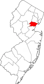 Map of New Jersey highlighting Union County | |
| Boroughs | ||
| Town | ||
| Townships | ||
| Unincorporated communities | ||
| ||
Places adjacent to Clark, New Jersey | |
|---|---|