Claydon, Saskatchewan
Claydon is an unincorporated community within the Rural Municipality of Frontier No. 19, Saskatchewan, Canada. The community is located 60 km southeast of the community of Robsart and 50 km south of the town of Eastend and 31 km West of Frontier, Saskatchewan on Highway 18. Very little remains of the former community, only a post office that was also formerly a grocery store, a community hall, and ball diamonds.
Claydon | |
|---|---|
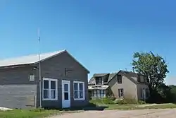 Claydon Post Office and house, Main Street. | |
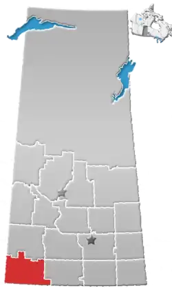
 Location of Claydon in Saskatchewan | |
| Coordinates: 49°07′44″N 108°32′31″W | |
| Country | Canada |
| Province | Saskatchewan |
| Region | South West Saskatchewan |
| Census division | 4 |
| Rural Municipality | Frontier |
| Established | 1917 |
| Village Incorporated | N/A |
| Government | |
| • Administrator | Barb Webber |
| • Governing body | Frontier No. 19 |
| Area | |
| • Total | 500.488 km2 (193.239 sq mi) |
| Population (2001) | |
| • Total | 10 |
| • Density | 0.020/km2 (0.052/sq mi) |
| Postal code | S0N 0M0 |
| Area code(s) | 306 |
| Highways | Highway 18 |
| [1][2][3][4] | |
Education
Claydon no longer has a school, but those who live in or near Claydon are now bused to the neighboring village of Frontier which has a school that covers Kindergarten to Grade 12 serving approximately 200 students.
Climate
| Climate data for Claydon (1981-2010) | |||||||||||||
|---|---|---|---|---|---|---|---|---|---|---|---|---|---|
| Month | Jan | Feb | Mar | Apr | May | Jun | Jul | Aug | Sep | Oct | Nov | Dec | Year |
| Record high °C (°F) | 13 (55) |
19 (66) |
20.5 (68.9) |
30 (86) |
34 (93) |
38 (100) |
37.5 (99.5) |
39.5 (103.1) |
35.5 (95.9) |
31 (88) |
22 (72) |
13 (55) |
39.5 (103.1) |
| Average high °C (°F) | −5.0 (23.0) |
−2.4 (27.7) |
3.7 (38.7) |
12.2 (54.0) |
17.8 (64.0) |
22.3 (72.1) |
27.0 (80.6) |
26.6 (79.9) |
19.5 (67.1) |
12.0 (53.6) |
2.0 (35.6) |
−3.5 (25.7) |
11.0 (51.8) |
| Daily mean °C (°F) | −10 (14) |
−7.6 (18.3) |
−1.8 (28.8) |
5.4 (41.7) |
10.9 (51.6) |
15.5 (59.9) |
19.3 (66.7) |
18.7 (65.7) |
12.3 (54.1) |
5.5 (41.9) |
−3.1 (26.4) |
−8.7 (16.3) |
4.7 (40.5) |
| Average low °C (°F) | −15.0 (5.0) |
−12.8 (9.0) |
−7.3 (18.9) |
−1.5 (29.3) |
3.9 (39.0) |
8.6 (47.5) |
11.5 (52.7) |
10.7 (51.3) |
5.0 (41.0) |
−1.0 (30.2) |
−8.3 (17.1) |
−13.7 (7.3) |
−1.7 (28.9) |
| Record low °C (°F) | −39.5 (−39.1) |
−39 (−38) |
−31.7 (−25.1) |
−22.2 (−8.0) |
−8.5 (16.7) |
−2.5 (27.5) |
2.8 (37.0) |
−2 (28) |
−9.4 (15.1) |
−26 (−15) |
−34 (−29) |
−42.5 (−44.5) |
−42.5 (−44.5) |
| Average precipitation mm (inches) | 18.1 (0.71) |
12.8 (0.50) |
21.5 (0.85) |
25.4 (1.00) |
59.2 (2.33) |
69.8 (2.75) |
50.3 (1.98) |
35.2 (1.39) |
40.9 (1.61) |
17.5 (0.69) |
18.2 (0.72) |
16.0 (0.63) |
385.0 (15.16) |
| Source: Environment Canada[5] | |||||||||||||
See also
- List of communities in Saskatchewan
- List of ghost towns in Canada
- Ghost towns in Saskatchewan
References
- National Archives, Archivia Net, Post Offices and Postmasters, archived from the original on 6 October 2006
- Government of Saskatchewan, MRD Home, Municipal Directory System, archived from the original (– Scholar search) on 21 November 2008
- Canadian Textiles Institute. (2005), CTI Determine your provincial constituency, archived from the original on 11 September 2007
- Commissioner of Canada Elections, Chief Electoral Officer of Canada (2005), Elections Canada On-line, archived from the original on 21 April 2007
- Environment Canada , accessed 24 July 2017
Places adjacent to Claydon, Saskatchewan | |
|---|---|
| Subdivisions | |
|---|---|
| Communities | |
| Cities | |
| Topics |
|
| |
This article is issued from Wikipedia. The text is licensed under Creative Commons - Attribution - Sharealike. Additional terms may apply for the media files.