Rural Municipality of Arlington No. 79
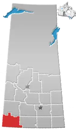
The Rural Municipality of Arlington No. 79 (2016 population: 366) is a rural municipality (RM) in the Canadian province of Saskatchewan within Census Division No. 4 and SARM Division No. 3. It is located in the southwestern region of the province east of Shaunavon.
Arlington No. 79 | |
|---|---|
| Rural Municipality of Arlington No. 79 | |
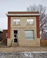 Administrative office in Shaunavon | |
 Location of the RM of Arlington No. 79 in Saskatchewan | |
| Coordinates: 49.624°N 108.659°W[1] | |
| Country | Canada |
| Province | Saskatchewan |
| Census division | 4 |
| SARM division | 3 |
| Federal riding | Cypress Hills—Grasslands |
| Provincial riding | Cypress Hills |
| Formed[2] | January 1, 1913 |
| Government | |
| • Reeve | Donald Lundberg |
| • Governing body | RM of Arlington No. 79 Council |
| • Administrator | Richard Goulet |
| • Office location | Shaunavon |
| Area (2016)[4] | |
| • Land | 846.79 km2 (326.95 sq mi) |
| Population (2016)[4] | |
| • Total | 366 |
| • Density | 0.4/km2 (1/sq mi) |
| Time zone | CST |
| • Summer (DST) | CST |
| Postal code | S0N 2M0 |
| Area code(s) | 306 and 639 |
| Highway(s) | Highway 13 Highway 613 Highway 633 Highway 724 |
| Waterway(s) | Lawrence Lake Jones Creek Swift Current Creek Eastend Coulee Rock Creek |

History
The RM of Arlington No. 79 incorporated as a rural municipality on January 1, 1913.[2]
Geography
Communities and localities
The following unincorporated communities are within the RM.
- Localities
Demographics
In the 2016 Census of Population conducted by Statistics Canada, the RM of Arlington No. 79 recorded a population of 366 living in 84 of its 97 total private dwellings, a 6.1% change from its 2011 population of 345. With a land area of 846.79 km2 (326.95 sq mi), it had a population density of 0.4/km2 (1.1/sq mi) in 2016.[4]
In the 2011 Census of Population, the RM of Arlington No. 79 recorded a population of 345, a -16.5% change from its 2006 population of 413. With a land area of 846.79 km2 (326.95 sq mi), it had a population density of 0.4/km2 (1.1/sq mi) in 2011.[7]
Government
The RM of Arlington No. 79 is governed by an elected municipal council and an appointed administrator that meets on the second Wednesday of every month.[3] The reeve of the RM is Donald Lundberg while its administrator is Richard Goulet.[3] The RM's office is located in Shaunavon.[3]
Transportation
| Highway | Starting point | Communities | Ending point |
|---|---|---|---|
| Highway 13 | Alberta Highway 501 | Dollard | Manitoba Highway 3 |
| Highway 613 | Highway 724 | Dollard | Highway 18 |
| Highway 633 | Tompkins | South Fork | Saskatchewan Highway 13 |
| Highway 724 | Highway 614 | Highway 37 | |
References
- "Pre-packaged CSV files - CGN, Canada/Province/Territory (cgn_sk_csv_eng.zip)". Government of Canada. July 24, 2019. Retrieved May 23, 2020.
- "Rural Municipality Incorporations (Alphabetical)". Saskatchewan Ministry of Municipal Affairs. Archived from the original on April 21, 2011. Retrieved May 9, 2020.
- "Municipality Details: RM of Arlington No. 79". Government of Saskatchewan. Retrieved May 21, 2020.
- "Population and dwelling counts, for Canada, provinces and territories, and census subdivisions (municipalities), 2016 and 2011 censuses – 100% data (Saskatchewan)". Statistics Canada. February 8, 2017. Retrieved May 1, 2020.
- "Saskatchewan Census Population" (PDF). Saskatchewan Bureau of Statistics. Archived from the original (PDF) on September 24, 2015. Retrieved May 9, 2020.
- "Saskatchewan Census Population". Saskatchewan Bureau of Statistics. Retrieved May 9, 2020.
- "Population and dwelling counts, for Canada, provinces and territories, and census subdivisions (municipalities), 2011 and 2006 censuses (Saskatchewan)". Statistics Canada. June 3, 2019. Retrieved May 1, 2020.