Rural Municipality of Reno No. 51
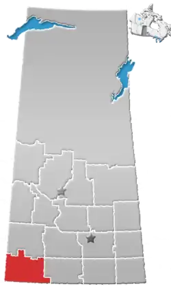
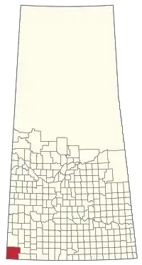
The Rural Municipality of Reno No. 51 (2016 population: 379) is a rural municipality (RM) in the Canadian province of Saskatchewan within Census Division No. 4 and SARM Division No. 3. Located in the southwest corner of the province, it is adjacent to the United States border to the south and the Alberta boundary to the west.
Reno No. 51 | |
|---|---|
| Rural Municipality of Reno No. 51 | |
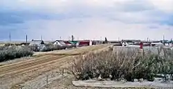 View of Robsart from the Robsart Hospital | |
 Location of the RM of Reno No. 51 in Saskatchewan | |
| Coordinates: 49.342°N 109.551°W[1] | |
| Country | Canada |
| Province | Saskatchewan |
| Census division | 4 |
| SARM division | 3 |
| Federal riding | Cypress Hills--Grasslands |
| Provincial riding | Cypress Hills |
| Formed[2] | December 11, 1911 |
| Government | |
| • Reeve | Brian McMillan |
| • Governing body | RM of Reno No. 51 Council |
| • Acting Administrator | Tanya Howell |
| • Office location | Consul |
| Area (2016)[4] | |
| • Land | 3,461.61 km2 (1,336.54 sq mi) |
| Population (2016)[4] | |
| • Total | 379 |
| • Density | 0.1/km2 (0.3/sq mi) |
| Time zone | CST |
| • Summer (DST) | CST |
| Postal code | S0N 0P0 |
| Area code(s) | 306 and 639 |
| Highway(s) | Highway 13 Highway 18 Highway 21 Highway 615 |
| Waterway(s) | Cypress Lake Battle Creek Middle Creek Lodge Creek |
History
The RM of Reno No. 51 incorporated as a rural municipality on December 11, 1911.[2] Reno, Nevada and Reno County, Kansas are both named for Jesse Lee Reno, a Union general in the American Civil War. However, no record exists of why the Saskatchewan RM's name might derive from this source. An alternative explanation is that RENO is an acronym of four rural post offices in the vicinity - Russthorn (near Robsart), Eden Valley (southwest of Cypress Lake), Nashlyn (south of Consul), and Oxarat (west of Cypress Lake). Although Nashlyn then lay outside the boundary of the RM, similar acronymic names are not unknown on the Canadian prairies; see also Sangudo, Alberta.[5]
Geography
The RM of Reno No. 51 is in the southwest corner of the province. It neighbours Hill County and Blaine County in Montana to the south and Cypress County in Alberta to the west. Within Saskatchewan, it is adjacent to the RMs of Maple Creek No. 111, White Valley No. 49, and Frontier No. 19.
Communities and localities
The following urban municipalities are surrounded by the RM.
The following unincorporated communities are located in the RM.
- Localities[6]
- Altwan
- Battle Creek
- Govenlock, dissolved as a village January 1, 1976
- Merryflat
- Nashlyn
- Notukeu
- Oxarat
- Palisade
- Rangeview
- Robsart, dissolved as a village January 1, 2002[7]
- Senate, dissolved as a village January 1, 1994
- Supreme
- Tyro
- Vidora, dissolved as a village January 1, 1952
- West Plains
- Willow Creek
Climate
| Climate data for WILLOW CREEK, SK (~Southwestern Reno No. 51, 1971-2000 Normals) | |||||||||||||
|---|---|---|---|---|---|---|---|---|---|---|---|---|---|
| Month | Jan | Feb | Mar | Apr | May | Jun | Jul | Aug | Sep | Oct | Nov | Dec | Year |
| Average high °C (°F) | −5.4 (22.3) |
−1.6 (29.1) |
4.8 (40.6) |
13.5 (56.3) |
19.3 (66.7) |
24.1 (75.4) |
27.8 (82.0) |
27.7 (81.9) |
20.9 (69.6) |
13.3 (55.9) |
2.3 (36.1) |
−3.3 (26.1) |
12 (54) |
| Average low °C (°F) | −17.8 (0.0) |
−14.4 (6.1) |
−7.8 (18.0) |
−1.8 (28.8) |
3.9 (39.0) |
8.3 (46.9) |
10.6 (51.1) |
9.8 (49.6) |
3.8 (38.8) |
−2.2 (28.0) |
−10 (14) |
−16.1 (3.0) |
−2.8 (27.0) |
| Average precipitation mm (inches) | 12.4 (0.49) |
7.8 (0.31) |
16 (0.6) |
15.6 (0.61) |
47.1 (1.85) |
60.6 (2.39) |
41.3 (1.63) |
30.9 (1.22) |
32.3 (1.27) |
16.3 (0.64) |
17 (0.7) |
16.6 (0.65) |
313.8 (12.35) |
| Source: Environment Canada[8] | |||||||||||||
Demographics
In the 2016 Census of Population conducted by Statistics Canada, the RM of Reno No. 51 recorded a population of 379 living in 156 of its 179 total private dwellings, a -5% change from its 2011 population of 399. With a land area of 3,461.61 km2 (1,336.54 sq mi), it had a population density of 0.1/km2 (0.3/sq mi) in 2016.[4]
In the 2011 Census of Population, the RM of Reno No. 51 recorded a population of 399, a -13.6% change from its 2006 population of 462. With a land area of 3,460.66 km2 (1,336.17 sq mi), it had a population density of 0.1/km2 (0.3/sq mi) in 2011.[11]
Attractions
- Local attractions
- Red Coat Trail
- Old Man on His Back Prairie and Heritage Conservation Area
- Cypress Lake
- Cypress Lake Provincial Recreation Site
- Heglund Island Provincial Wildlife Refuge
- Regional attractions
Government
The RM of Reno No. 51 is governed by an elected municipal council and an appointed administrator that meets on the second Monday of every month.[3] The reeve of the RM is Brian McMillan while its administrator is Tanya Howell.[3] The RM's office is located in Consul.[3]
Transportation
The following is a list of Saskatchewan highways and provincial roads, railways, and other forms of transportation that service the area.
- Highway 13
- Highway 18
- Highway 21
- Highway 615
- Highway 271
- Great Western Railway – a Canadian short line railway company operating on former Canadian Pacific Railway trackage in southwest Saskatchewan
References
- "Pre-packaged CSV files - CGN, Canada/Province/Territory (cgn_sk_csv_eng.zip)". Government of Canada. July 24, 2019. Retrieved May 23, 2020.
- "Rural Municipality Incorporations (Alphabetical)". Saskatchewan Ministry of Municipal Affairs. Archived from the original on April 21, 2011. Retrieved May 9, 2020.
- "Municipality Details: RM of Reno No. 51". Government of Saskatchewan. Retrieved May 21, 2020.
- "Population and dwelling counts, for Canada, provinces and territories, and census subdivisions (municipalities), 2016 and 2011 censuses – 100% data (Saskatchewan)". Statistics Canada. February 8, 2017. Retrieved May 1, 2020.
- Barry, Bill (2005). Geographic Names of Saskatchewan. Regina, Saskatchewan: People Places Publishing Ltd. ISBN 1-897010-19-2.
- Standard Geographical Classification (SGC) 2001
- "Covered population 2002" (PDF). Saskatchewan Health. Archived from the original (PDF) on May 27, 2011. Retrieved April 17, 2008.
- "Canadian Climate Normals 1971-2000 Station Data". Environment Canada. Retrieved November 11, 2013.
- "Saskatchewan Census Population" (PDF). Saskatchewan Bureau of Statistics. Archived from the original (PDF) on September 24, 2015. Retrieved May 9, 2020.
- "Saskatchewan Census Population". Saskatchewan Bureau of Statistics. Retrieved May 9, 2020.
- "Population and dwelling counts, for Canada, provinces and territories, and census subdivisions (municipalities), 2011 and 2006 censuses (Saskatchewan)". Statistics Canada. June 3, 2019. Retrieved May 1, 2020.
- T. rex Discovery Centre, Eastend, Saskatchewan
Places adjacent to Rural Municipality of Reno No. 51 | ||||||||||
|---|---|---|---|---|---|---|---|---|---|---|
| ||||||||||