Dakahlia Governorate
Dakahlia Governorate (Arabic: محافظة الدقهلية Muḥāfaẓah el Daqahliyah, pronounced [ed.dæʔæhˈlejjæ]) is an Egyptian governorate lying northeast of Cairo. Its area is approximately 3,500 km². Its capital is Mansoura.
Dakahlia Governorate | |
|---|---|
 Flag  | |
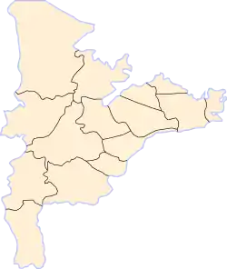 Dakahlia Governorate subdivisions | |
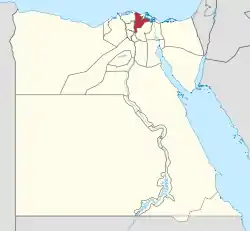 Dakahlia Governorate on the map of Egypt | |
| Country | |
| Seat | Mansoura (capital) |
| Government | |
| • Governor | Kamal Gad Sharobim Saad[1] |
| Area | |
| • Total | 3,500 km2 (1,400 sq mi) |
| Population (January 2018) | |
| • Total | 6,577,000[2] |
| Time zone | UTC+2 (EET) |
| HDI (2017) | 0.714[3] high · 7th |
| Website | www |
History
Archaeology
According to the Egypt's Ministry of Antiquities, in February, 2020, Egyptian archaeologists have uncovered 83 tombs dating back to 4,000 B.C known as Naqada III period. Various small pottery pots in different shapes and some sea shells, makeup tools, eyeliner pots, and jewels were also revealed in the burial.[4][5]
Municipal divisions
The governorate is divided into the following municipal divisions and in July 2017 had an estimated population of 6,516,489. At times there is a kism and a markaz with the same name.[6][7]
| Anglicized name | Native name | Arabic transliteration | Population (July 2017 Est.) | Type |
|---|---|---|---|---|
| Aga | مركز أجا | Agā | 538,484 | Markaz |
| El Gamaliya | مركز الجمالية | Al-Gamāliyah | 138,291 | Markaz |
| El Kurdi | قسم الكردى | Al-Kurdi | 39,585 | Kism (fully urban) |
| El Mansoura | مركز المنصورة | Al-Manṣūrah | 621,439 | Markaz |
| El Mansoura 1 | قسم اول المنصورة | Al-Manṣūrah 1 | 313,021 | Kism (fully urban) |
| El Mansoura 2 | قسم ثان المنصورة | Al-Manṣūrah 2 | 235,238 | Kism (fully urban) |
| El Manzala | مركز المنزلة | Al-Manzilah | 360,649 | Markaz |
| El Matareya | مركز المطرية | Al-Maṭariyah | 178,857 | Markaz |
| El Senbellawein | مركز السنبلاوين | As-Sinbillāwayn | 567,560 | Markaz |
| Beni Ebeid | مركز بنى عبيد | Banī Ubayd | 131,492 | Markaz |
| Belqas | مركز بلقاس | Bilqās | 531,203 | Markaz |
| Dikirnis | مركز دكرنس | Dikirnis | 353,820 | Markaz |
| Gamasa | قسم جمصة | Gamaṣah | 3,922 | Kism (fully urban) |
| Maḥallat Damanah | مركز محلة دمنة | Maḥallat Damanah | 61,835 | Markaz |
| Minyet El Nasr | مركز منية النصر | Minyat an-Naṣr | 267,431 | Markaz |
| Mit Ghamr | قسم ميت غمر | Mīt Ghamr | 135,544 | Kism (fully urban) |
| Mit Ghamr | مركز ميت غمر | Mīt Ghamr | 663,369 | Markaz |
| Mit Salsil | مركز ميت سلسيل | Mīt Salsīl | 73,417 | Markaz |
| Nabaroh | مركز نبروة | Nabarūh | 283,034 | Markaz |
| Shirbin | مركز شربين | Shirbīn | 427,866 | Markaz |
| Talkha | مركز طلخا | Ṭalkhā | 392,383 | Markaz |
| Timay El Imdid | مركز تمى الأمديد | Timay al-Imdīd | 198,049 | Markaz |
Population
According to population estimates, in 2015 the majority of residents in the governorate lived in rural areas, with an urbanization rate of 28.2%. Out of an estimated 5,949,001 people residing in the governorate, 4,271,428 people lived in rural areas as opposed to 1,677,573 in urban areas.[8] By 2018, the population had increased to an estimated 6,577,000.[2]
Overview
The Urology and Nephrology Center of Mansoura University Faculty of Medicine also features a renowned kidney center. Founded in 1983. Under the management of Dr. Mohamed A. Ghoneim.
Cities and towns
- Aga
- Bilqas
- Damas
- Dikirnis
- El Gamaliya
- El Kurdi
- El Matareya
- El Senbellawein
- Gamasa
- Gogar
- Mansoura
- Manzala
- Mit Elkorama
- Mit Ghamr
- Mit Salsil
- Nabaroh
- Sherbin
- Temay El Amdeed
- Talkha
Industrial zones
According to the Egyptian Governing Authority for Investment and Free Zones (GAFI), in affiliation with the Ministry of Investment (MOI), the following industrial zones are located in this governorate:[9]
- Southwest Gamasa
- Asafra
Notable people
Arts
- Ahmad Hasan al-Zayyat, writer and intellectual
- Anis Mansour, writer
- Ali Mahmoud Taha, romantic poet
- Adel Emam, movie and stage actor
- Faten Hamama, actress and producer
- Hassan al-Imam, film director
- Iman Mersal, poet
- Khaled El Nabawy, actor
- Mohamed Abla, artist
- Mahmoud Mokhtar, sculptor
- Naguib Surur, poet and playwright
- No'man Ashour, poet and playwright
- Ramy Essam, musician
- Sherif Mounir, movie and stage actor
- Umm Kulthum, renowned singer and songwriter
Journalists
- Ahmed Mansour (journalist)
- Mohamed Makhzangi, journalist and writer
- Mohammed Hussein Heikal, journalist, writer and politician
- Magdi Mehanna
Politics
- Ali Pasha Mubarak, one of the most influential and talented of Egypt's 19th century reformers
- Ayman Nour, politician
- Ahmed Gamal El-Din Moussa, former minister
- Ahmed Lutfi el-Sayed, intellectual, secularist and nationalist
- Abdel Latif Boghdadi, politician
- Khaled Ali, lawyer and Acitvist
- Khairat el-Shater, Islamic political activist
- Mohammed Mahdi Akef, former head of Muslim Brotherhood
- Mohamed Abdul Salam Mahgoub, politician
- Omar Abdel-Rahman, Muslim leader and activist
- Sami Hafez Anan, military officer
- Salah Nasr, former intelligence agency director
Religion
- Gad el-Haq, former Grand Imam of Al-Azhar
- George El Mozahem, Coptic Orthodox martyr and saint
- Mohamed Metwally Al-Shaarawy, Islamic scholar
- Mahmoud Zakzouk, academic and politician
Science
- Farouk El-Baz, space scientist
- Mohamed Ghoneim, urologist
- Saad Eddin Ibrahim, academic and sociologist
- Selim Hassan, Egyptologist
Sports
- Ōsunaarashi Kintarō (Abdelrahman Shalan) sumo wrestler
- Abdel-Zaher El-Saqqa, footballer
- Amr Marey, footballer
- Hussam El-Badrawi, sports shooter
- Mahmoud Fathalla, footballer
- Mahmoud El Khatib, footballer
- Mahmoud Abou El-Saoud, footballer
- Mohamed El Shamy (footballer, born 1996)
- Mimi El-Sherbini, footballer
- Salah Soliman, footballer
References
- "رسمياً.. المحافظون الجدد ونوابهم يؤدون اليمين الدستورية أمام الرئيس". Almasry Alyoum (in Arabic). 30 August 2018. Archived from the original on 2018-08-31. Retrieved 2018-08-31.
- "Population Estimates By Governorate ( Urban /Rural ) 1/1/2018". www.capmas.gov.eg. Archived from the original on 2018-11-02. Retrieved 10 October 2018.
- "Sub-national HDI - Area Database - Global Data Lab". hdi.globaldatalab.org. Retrieved 2018-09-13.
- February 2020, Laura Geggel-Associate Editor 21. "Dozens of ancient Egyptian graves found with rare clay coffins". livescience.com. Retrieved 2020-06-28.
- "الكشف عن 83 مقبرة أثرية بمنطقة آثار كوم الخلجان بمحافظة الدقهلية". اليوم السابع. 2020-02-12. Retrieved 2020-06-28.
- "Dakahlia Governorate Subdivisions". CityPopulation.de. Archived from the original on 2018-11-25. Retrieved 2018-11-24.
- "Markazes of Egypt". statoids.com. Gwillim Law. Archived from the original on 2017-10-19. Retrieved 26 November 2018.
- "Population Estimates By Sex & Governorate 1/1/2015" (PDF). CAPMAS. Archived (PDF) from the original on 2015-10-19. Retrieved 23 October 2016.
- "Industrial Zones of Governorate". Ministry of Investment Egypt. Archived from the original on 2018-11-23. Retrieved 23 November 2018.
External links
| Wikimedia Commons has media related to Dakahlia Governorate. |
- Dakahliya Governorate Official website
- Dakahlia page
- El Wattan News of Dakahlia Governorate
| Urban | ||
|---|---|---|
| Lower Egypt | ||
| Upper Egypt | ||
| Frontier | ||
| Authority control |
|---|