Kafr El Sheikh Governorate
Kafr El Sheikh Governorate is one of the governorates of Egypt. It lies in the northern part of the country, along the western branch of the Nile in the Nile Delta. Its capital is the city of Kafr El Sheikh.
Kafr El Sheikh Governorate | |
|---|---|
 Flag  | |
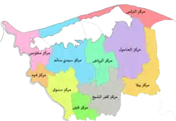 Kafr El Sheikh Governorate subdivisions | |
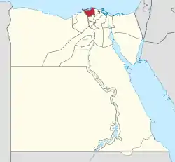 Kafr El Sheikh Governorate on the map of Egypt | |
| Coordinates: 31.3°N 30.93°E | |
| Country | |
| Seat | Kafr El Sheikh (capital) |
| Government | |
| • Governor | Gamal Nour El-Dein mohamed Zaki [1] |
| Area | |
| • Total | 3,437 km2 (1,327 sq mi) |
| Population (January 2018) | |
| • Total | 3,414,000[2] |
| Time zone | UTC+2 (EET) |
| HDI (2017) | 0.703[3] high · 10th |
| Website | www |
Kafr El Sheikh is the first nationwide in the cultivation of long-staple cotton for export.
Overview
Kafr El Sheikh Governorate, which was once part of the Gharbia Governorate, was created in 1949. It was originally named Fuadiyah in honor of King Fuad I of Egypt. After the 1952 Revolution and the subsequent abolition of the monarchy, the governorate took the name of its capital city Kafr El Sheikh. This name, adopted in 1955, means "the village of the chief".[4]
The area occupied today by the Kafr El Sheikh Governorate has been inhabited since ancient times and so it has a noteworthy number of archaeological sites, at Tell Metoubes, Fuwwah, Desouk, Tell Qabrit, and other settlements around Lake Burrulus. The capital of Lower Egypt, called "Buto", is located at present-day Tell El Faraain (the Hill of the Pharaohs), near Desouk.[5]
Municipal divisions
The governorate is divided into municipal divisions, with a total estimated population as of July 2017 of 3,376,809. In some instances there is a markaz and a kism with the same name.[6][7]
| Anglicized name | Native name | Arabic transliteration | Population (July 2017 Est.) | Type |
|---|---|---|---|---|
| Burullus | مركز البرلس | Al-Burulus | 236,095 | Markaz |
| El Hamool | مركز الحامول | Al-Ḥāmūl | 290,628 | Markaz |
| El Reyad | مركز الرياض | Ar-Riyād | 186,960 | Markaz |
| Bila | قسم بيلا | Bilā | 81,354 | Kism (fully urban) |
| Bila | مركز بيلا | Bilā | 217,398 | Markaz |
| Desouk | قسم دسوق | Disūq | 136,367 | Kism (fully urban) |
| Desouk | مركز دسوق | Disūq | 412,682 | Markaz |
| Fuwa | مركز فوه | Fuwah | 179,800 | Markaz |
| Kafr el Sheikh | مركز كفر الشيخ | Kafr ash-Shaykh | 448,532 | Markaz |
| Kafr el Sheikh 1 | قسم أول كفر الشيخ | Kafr ash-Shaykh 1 | 141,525 | Kism (fully urban) |
| Kafr el Sheikh 2 | قسم ثان كفر الشيخ | Kafr ash-Shaykh 2 | 36,200 | Kism (fully urban) |
| Metoubes | مركز مطوبس | Muṭūbis | 303,537 | Markaz |
| Qallin | مركز قلين | Qallīn | 266,195 | Markaz |
| Sidi Salem | مركز سيدى سالم | Sīdī Sālim | 439,536 | Markaz |
Population
According to population estimates, in 2015 the majority of residents in the governorate lived in rural areas, with an urbanization rate of only 23.1%. Out of an estimated 3,172,753 people residing in the governorate, 2,441,246 people lived in rural areas as opposed to only 731,507 in urban areas.[8]
Cities and towns
Lake Burullus is located in the north of the Kafr El Sheikh governorate. The following are in Kafr El Sheikh:
Industrial zones
According to the Egyptian Governing Authority for Investment and Free Zones (GAFI), in affiliation with the Ministry of Investment (MOI), the following industrial zones are located in this governorate:[9]
- Balteem
- Metobas
- Industrial Zone in "mlaha of Moneisi"
Projects and programs
In 2016, Switzerland committed to funding a solid waste management program in Kafr El Sheikh, a project with the Egyptian Ministry of Environment that will conclude in 2021. The National Solid Waste Management Programme (NSWMP) involves the construction of infrastructure for new as well as the expansion and improvement of existing waste treatment, landfill, and recycling facilities.[10]
Economy
Industries include cotton-processing factories, rice and fishing. Kafr Elsheikh is also home to one of the biggest sugar factories in the region.
Education
Kafr El Sheikh University comprises faculties for medicine , commerce, engineering, agriculture, veterinary medicine, arts, physical education, science, education, special education, dentistry, physical therapy, alsun and pharmacy.
Notable residents
References
- "رسمياً.. المحافظون الجدد ونوابهم يؤدون اليمين الدستورية أمام الرئيس". Almasry Alyoum (in Arabic). 30 August 2018. Archived from the original on 2018-08-31. Retrieved 2018-08-31.
- "Population Estimates By Governorate ( Urban /Rural ) 1/1/2018". www.capmas.gov.eg. Archived from the original on 2018-11-02. Retrieved 10 October 2018.
- "Sub-national HDI - Area Database - Global Data Lab". hdi.globaldatalab.org. Retrieved 2018-09-13.
- Room, Adrian (2006). Placenames of the World: Origins and Meanings of the Names for 6,600 Countries, Cities, Territories, Natural Features, and Historic Sites (2nd ed.). Jefferson, NC: McFarland. p. 185. ISBN 978-0-7864-2248-7. Retrieved 2010-08-07.
- Wilson, Penelope Grigoropoulos, Dimitris (2009). West Delta Regional Survey, Beheira and Kafr el-Sheikh Provinces. Excavation memoir. London : Egypt Exploration Society. ISBN 9780856981944. OCLC 690191661.
- "Kafr El Sheikh Governorate Subdivisions". CityPopulation.de. Archived from the original on 2018-09-02. Retrieved 2018-11-23.
- "Markazes of Egypt". statoids.com. Gwillim Law. Archived from the original on 2017-10-19. Retrieved 26 November 2018.
- "Population Estimates By Sex & Governorate 1/1/2015" (PDF). CAPMAS. Archived from the original (PDF) on 2015-10-19. Retrieved 23 October 2016.
- "Industrial Zones of Governorate". Ministry of Investment Egypt. Archived from the original on 2018-11-23. Retrieved 23 November 2018.
- "Switzerland funds programme to improve solid waste management in 4 Egyptian governorates". Daily News Egypt. 5 October 2016.
External links
- El Watan News of Kafr El Sheikh Governorate
- UNDP Kafr ash Shaykh Human Development Index Indicator's page
| Urban | ||
|---|---|---|
| Lower Egypt | ||
| Upper Egypt | ||
| Frontier | ||
| Authority control |
|---|