Minya Governorate
Minya Governorate (Arabic: محافظة المنيا Muḥāfẓet El Minya) is one of the governorates of Upper Egypt. Its capital city, Minya, is located on the left bank of the Nile River.[4]
Minya Governorate | |
|---|---|
 Flag  | |
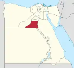 Minya Governorate on the map of Egypt | |
| Coordinates: 28.11°N 30.11°E | |
| Country | |
| Seat | Minya (capital) |
| Government | |
| • Governor | Essam El Badawy[1] |
| Area | |
| • Total | 32,279 km2 (12,463 sq mi) |
| Population (March 2019) | |
| • Total | 5,807,000[2] |
| Time zone | UTC+2 (EET) |
| HDI (2017) | 0.657[3] medium |
| Website | www |
Etymology
The name originates from the chief city of the governorate, originally known in Sahidic Coptic as Tmoone and in Bohairic as Thmonē, meaning “the residence”, in reference to a monastery formerly in the area. The name may also originate from the city's name in Egyptian Men'at Khufu.
Overview
The rate of poverty is more than 60% in this governorate, where the total population is nearly 6 million. Recently the government has provided some assistance via social safety networks, specifically, some financial assistance to residents with disabilities, and job opportunities for them and others. The funding has been coordinated by the country's Ministry of Finance and with assistance from international organizations.[5]
Municipal divisions
The governorate is divided into municipal divisions with a total estimated population as of March 2019 of 5,807,919. In the case of Minya governorate, there are a number of aqsam and marakiz, and a new city. Sometimes a markaz and a kism share a name.[6][7]
| Anglicized name | Native name | Arabic transliteration | Population (July 2017 Est.) | Type |
|---|---|---|---|---|
| Abu Qirqas | مركز ابو قرقاص | Abū Qurqās | 604,773 | Markaz |
| El Idwa | مركز العدوة | Al-'Idwah | 281,729 | Markaz |
| Minya | مركز المنيا | Al-Minyā | 679,821 | Markaz |
| Minya 1 | قسم أول المنيا | Al-Minyā 1 | 46,999 | Kism (fully urban) |
| Minya 2 | قسم ثان المنيا | Al-Minyā 2 | 108,689 | Kism (fully urban) |
| Minya 3 | قسم ثالث المنيا | Al-Minyā 3 | 89,790 | Kism (fully urban) |
| Beni Mazar | مركز بنى مزار | Banī Mazār | 639,122 | Markaz |
| Deir Mawas | مركز دير مواس | Dayr Mawās | 412,089 | Markaz |
| New Minya | مدينة المنيا الجديدة | Madīnat al-Minyā al-Jadīdah | 15,122 | New City |
| Maghagha | مركز مغاغة | Maghāghah | 596,474 | Markaz |
| Malawit Gharb | مركز سمالوط غرب | Malawiṭ Gharb | 488,482 | Markaz |
| Mallawi | قسم ملوى | Mallawī | 184,048 | Kism (fully urban) |
| Mallawi | مركز ملوى | Mallawī | 748,372 | Markaz |
| Matai | مركز مطاى | Maṭāy | 319,592 | Markaz |
| Samalut | مركز سمالوط | Samālūṭ | 311,817 | Markaz |
Cities and towns
As of 2018, 10 cities (or towns) in Minya had a population of over 15,000 inhabitants.[8]
| English name | Native name | Arabic transliteration | Nov. 1996 Census | Nov. 2006 Census | Population (July 2017 Est.) |
|---|---|---|---|---|---|
| Abu Qirqas | أبو قرقاس | Abū Qurqās | 50,031 | 57,892 | 78,134 |
| El Idwa | العدوه | Al-'Idwah | 13,553 | 15,875 | 22,583 |
| Minya | المنيا | Al-Minyā | 201,440 | 236,043 | 245,478 |
| New Minya | المنيا الجديدة | Al-Minyā al-Jadīdah | 68 | 4,567 | 15,122 |
| Beni Mazar | بنى مزار | Banī Mazār | 52,690 | 79,553 | 100,201 |
| Deir Mawas | دير مواس | Dayr Mawās | 33,197 | 40,640 | 52,658 |
| Maghagha | مغاغ | Maghāghah | 60,405 | 75,657 | 102,328 |
| Mallawi | ملوى | Mallawī | 119,285 | 139,929 | 184,048 |
| Matai | ماتاى | Maṭāy | 36,953 | 46,903 | 71,263 |
| Samalut | سمالوط | Samālūṭ | 75,437 | 91,475 | 122,919 |
Population
According to population estimates from 2015 the majority of residents in the governorate live in rural areas, with an urbanization rate of only 18.9%. Out of an estimated 5,566,702 people residing in the governorate, 4,683,284 people live in rural areas as opposed to only 979,418 in urban areas.[9]
History
Little is known today about Minya Governorate compared to its great wealth of archaeological sites. Its history, including Ancient Egyptian, Hellenistic, Roman and Arab periods, has not yet received the full attention of scholars.
Ancient Egyptian period
Dehnet, Fraser Tombs, Sharuna, and Zawyet el-Maiyitin comprise monuments dating back to the Old Kingdom.
The village of Bani Hasan al Shurruq houses 390 rock-cut decorated tombs and chapels from the Middle Kingdom (2000–1580 BC, especially the sixteenth dynasty). The Speos Artemidos is nearby, and hosts temples built by Queen Hatshepsut.
Akhetaten was built by Pharaoh Akhenaten and dedicated to the god Aten. Akhenaten lived there in isolation with his wife, Nefertiti, and daughters, devoting himself to the monotheistic religion that he preached. The glorious remains of the palaces, temples and tombs still exist today.
Other significant archaeological sites in the governorate of Minya include Deir Abu Hinis, Deir el-Bersha, El-Sheikh Sa'id, and Tuna el-Gebel.
Greco-Roman period
El Ashmunein (Hermopolis Magna) was the capital of the region during this period. It was the main center of worship of the god Thoth. Today, the ruins of a Greek temple, similar to the Parthenon, can be still found.
The tomb and chapel of Petosiris are found near the modern village of Tuna el-Gebel.
Antinoöpolis was built in 130 A.D. by the Roman emperor Hadrian in memory of his favourite and eromenos Antinous.
Byzantine period
The Monastery of the Virgin Mary at Gebel el-Teir is an important Christian site near the city of Samalut. Its church was built by Empress Helena, mother of Constantine the Great, in 328, on one of the sites where the Holy Family is believed to have stayed during its Flight into Egypt.
Oxyrhynchus was an important administrative center during the Hellenistic Period, and remains an important archaeological source for papyri from the Byzantine Egypt.
Modern history
Today, Minya Governorate has the highest concentration of Coptic Christians of 50% of the total population. There are also a number of active monasteries in the region.
In 2018, a Coptic cathedral was consecrated by Pope Tawadros II in the small village of Al Ur, near Samalut. The new cathedral was dedicated to the 21 Coptic Martyrs of Libya, thirteen of whom were from Al Ur.[10]
Archaeology
In February 2019, fifty mummy collections wrapped in linen, stone coffins or wooden sarcophagi dated back to the Ptolemaic Kingdom were discovered by Egyptian archaeologists in the Tuna El-Gebel site. 12 of the graves in four burial chambers 9m (30ft) deep, belonged to children. One of the remains was the partly uncovered skull enclosed in linen.[11][12]
In May 2020, Egyptian-Spanish archaeological mission headed by Esther Ponce revealed a unique cemetery consist of one room built with glazed limestone dating back to the 26th Dynasty (so-called the El-Sawi era) at the site of ancient Oxyrhynchus. Archaeologists also uncovered bronze coins, clay seals, Roman tombstones and small crosses.[13][14][15][16]
Projects
In 1981, the Basic Village Service Program (BVS) of USAID, had several water, and road projects, going on in several markazes in the Minya Governorate.[17] In 2013, The United Nations Trust Fund for Human Security helped farmers in Minya by doing consultation work with them and taking soil samples.[18]
National holiday
The national holiday of the Minya governorate is on 18 March. It commemorates those who were executed by the British at Deir Mawas on 18 March 1919.
Industrial zones
According to the Egyptian Governing Authority for Investment and Free Zones (GAFI), in affiliation with the Ministry of Investment (MOI), the following industrial zones are located in this governorate:[19]
- Al Matahra, east of the Nile
- Heavy industrial zone - Wadi el Sararyah
- New Minya
Agriculture and industry

Minya Governorate is an important agricultural and industrial region. Among its principal crops are sugarcane, cotton, beans, soybeans, garlic, onions, vegetables of various sorts, tomatoes, potatoes, watermelons, and grapes. Among the leading local industries are food processing (especially sugar and the drying and grinding of onions), spinning and weaving of cotton, perfumes, oils and fats, cement-making, quarrying (especially limestone), and brick-making.[20]
Important sites
- Akhetaten (Amarna)
- Dehenet (Akoris or Tihna el-Gebel)
- Ansena (Antinoöpolis or Sheikh Ibada)
- Beni Hasan
- Deir el-Bersha
- el-Sheikh Sa'id
- Fraser Tombs
- Hatnub
- Hebenu (Kom el-Ahmar)
- Herwer (Hur)
- Khmun (Hermopolis Magna or el-Ashmunein)
- Per Medjed (Oxyrhynchus or el-Bahnasa)
- Sharuna (el-Kom el-Ahmar Sawaris)
- Speos Artemidos (Istabl Antar)
- Tuna el-Gebel
- Zawyet el-Maiyitin
Monasteries in the Minya Governorate
Notable people
- Abdel Hakim Amer, military general
- Akhenaten, Pharaoh of the Eighteenth dynasty
- Akram Habib, Biblical scholar and social activist
- Hakim, folkloric singer
- Hoda Shaarawi, female activist
- Khufu, second Pharaoh of the Fourth dynasty
- Louis Awad, writer and intellectual
- Maria al-Qibtiyya, wife of Muhammad
- Sanaa Gamil, actress
- Suzanne Mubarak, the former first lady of Egypt
- Taha Hussein, writer and intellectual
- Mervat Amin, artist
- Ahmed Hassan, leader of Egyptian Football Team
- Alla Mohammed Hassan Limt , Musician
Statistics
- Total area: 32,279 km².
- Percentage to total area of Egypt: 3.2%.
- Population: around 5.8 million
- Population density: 115 people/km²
- Rural population:
- Percentage to the whole population of Egypt: 5.1%
- Population growth rate:
- Minya Governorate administrative divisions: 9 localities, 57 local administrative units, 346 small villages, and 1,429 tiny villages.
See also
Sources
- The Egyptian Tourist Authority, - ETA.
References
- "رسمياً.. المحافظون الجدد ونوابهم يؤدون اليمين الدستورية أمام الرئيس". Almasry Alyoum (in Arabic). 30 August 2018. Archived from the original on 2018-08-31. Retrieved 2018-08-31.
- "Population Estimates By Governorate ( Urban /Rural ) 1/1/2018". www.capmas.gov.eg. Archived from the original on 2018-11-02. Retrieved 10 October 2018.
- "Sub-national HDI - Area Database - Global Data Lab". hdi.globaldatalab.org. Retrieved 2018-09-13.
- Merriam Webster's Geographical Dictionary (Third ed.). Merriam Webster. 1998. p. 354.
- "Social Solidarity Ministry to provide citizens with disabilities financial support". Egypt Independent. 25 July 2017. Retrieved 11 December 2018.
- "Minya Governorate Subdivisions". CityPopulation.de. Archived from the original on 2018-04-28. Retrieved 2018-11-23.
- "Markazes of Egypt". statoids.com. Gwillim Law. Archived from the original on 2017-10-19. Retrieved 26 November 2018.
- "Cities". CityPopulation.de. Archived from the original on 2018-10-05. Retrieved 2018-11-24.
- "Population Estimates By Sex & Governorate 1/1/2015" (PDF). CAPMAS. Archived from the original (PDF) on 2015-10-19. Retrieved 23 October 2016.
- Darg, Christine (18 February 2018). "New Egyptian Cathedral for 21 Martyrs". Jerusalem Channel. Retrieved 16 February 2019.
- "Egypt mummies: New tombs found in Minya". BBC News. 2019-02-02. Retrieved 2020-09-11.
- "Tomb with 50 mummies found in Egypt". akipress.com. Retrieved 2020-09-11.
- "StackPath". dailynewsegypt.com. Retrieved 2020-09-09.
- "Unique cemetery dating back to el-Sawi era discovered in Egypt amid coronavirus crisis". Zee News. 2020-05-28. Retrieved 2020-09-09.
- Mahmoud, Rasha (2020-05-26). "Egypt makes major archaeological discovery amid coronavirus crisis". Al-Monitor. Retrieved 2020-09-09.
- "البعثة الإسبانية تكتشف مقبرة أثرية نادرة وعملات برونزية بـ«البهنسا» في المنيا | المصري اليوم". www.almasryalyoum.com (in Arabic). Retrieved 2020-09-09.
- "Egypt: The Basic Village Services Program" (PDF). USAID. Archived (PDF) from the original on 2016-10-19. Retrieved 19 October 2016.
- "UN Beneficiary Stories by UNIDO" (PDF). United Nations (unocha). Retrieved 24 November 2016.
- "Industrial Zones of Governorate". Ministry of Investment Egypt. Archived from the original on 2018-11-23. Retrieved 23 November 2018.
- "Al-Minyā GOVERNORATE, EGYPT". britannica.
External links
| Wikimedia Commons has media related to Minya Governorate. |
| Urban | ||
|---|---|---|
| Lower Egypt | ||
| Upper Egypt | ||
| Frontier | ||
| Authority control |
|---|