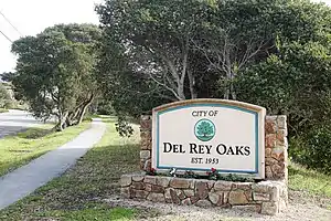
Del Rey Oaks, California
Del Rey Oaks, formerly Del Rey Woods,[8] is a city in Monterey County, California, United States. Del Rey Oaks is located just southeast of Seaside,[8] at an elevation of 82 feet (25 m).[6] The population was 1,624 at the 2010 census. Del Rey Oaks is a member of the Association of Monterey Bay Area Governments, a regional government agency.
City of Del Rey Oaks | |
|---|---|
City | |
 | |
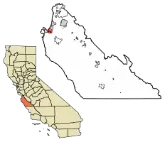 Location of Del Rey Oaks in Monterey County, California. | |
 City of Del Rey Oaks Location in the United States | |
| Coordinates: 36°35′36″N 121°50′06″W | |
| Country | |
| State | |
| County | Monterey |
| Incorporated | September 3, 1953[1] |
| Government | |
| • Mayor | Alison Kerr[2] |
| • State Senator | John Laird (D)[3] |
| • Assemblymember | Mark Stone (D)[3] |
| • U. S. Rep. | Jimmy Panetta (D)[4] |
| Area | |
| • Total | 0.45 sq mi (1.18 km2) |
| • Land | 0.45 sq mi (1.17 km2) |
| • Water | 0.00 sq mi (0.01 km2) 0.42% |
| Elevation | 82 ft (25 m) |
| Population (2010) | |
| • Total | 1,624 |
| • Estimate (2019)[7] | 1,654 |
| • Density | 3,659.29/sq mi (1,413.55/km2) |
| Time zone | UTC−08:00 (PST) |
| • Summer (DST) | UTC−07:00 (PDT) |
| ZIP Code | 93940 |
| Area code | 831 |
| FIPS code | 06-18688 |
| GNIS feature ID | 1658400 |
| Website | www |
Geography
Del Rey Oaks is located at 36°35′36″N 121°50′06″W.[6]
According to the United States Census Bureau, the city has a total area of 0.5 square miles (1.3 km2), 99.58% of it land and 0.42% of it water.
Climate
This region experiences warm (but not hot) and dry summers, with no average monthly temperatures above 71.6 °F. According to the Köppen Climate Classification system, Del Rey Oaks has a warm-summer Mediterranean climate, abbreviated "Csb" on climate maps.[9]
History
Prior to incorporation (on September 3, 1953[10]) the town was called Del Rey Woods. The Del Rey Oaks post office opened in 1968.[8]
Demographics
| Historical population | |||
|---|---|---|---|
| Census | Pop. | %± | |
| 1960 | 1,831 | — | |
| 1970 | 1,823 | −0.4% | |
| 1980 | 1,557 | −14.6% | |
| 1990 | 1,661 | 6.7% | |
| 2000 | 1,650 | −0.7% | |
| 2010 | 1,624 | −1.6% | |
| 2019 (est.) | 1,654 | [7] | 1.8% |
| U.S. Decennial Census[11] | |||

2010
The 2010 United States Census reported that Del Rey Oaks had a population of 1,624.[12] The population density was 3,362.3 people per square mile (1,298.2/km2). The racial makeup of Del Rey Oaks was 1,326 (81.7%) White, 16 (1.0%) African American, 12 (0.7%) Native American, 128 (7.9%) Asian, 4 (0.2%) Pacific Islander, 52 (3.2%) from other races, and 86 (5.3%) from two or more races. Hispanic or Latino of any race were 169 people (10.4%).
The census reported that 1,624 people (100% of the population) lived in households, none lived in non-institutionalized group quarters, and none were institutionalized.
There were 701 households, 164 (23.4%) had children under the age of 18 living in them, 361 (51.5%) were opposite-sex married couples living together, 57 (8.1%) had a female householder with no husband present, 25 (3.6%) had a male householder with no wife present. There were 28 (4.0%) unmarried opposite-sex partnerships, and 9 (1.3%) same-sex married couples or partnerships. 209 households (29.8%) were one person and 90 (12.8%) had someone living alone who was 65 or older. The average household size was 2.32. There were 443 families (63.2% of households); the average family size was 2.86.
The age distribution was 284 people (17.5%) under the age of 18, 92 people (5.7%) aged 18 to 24, 412 people (25.4%) aged 25 to 44, 528 people (32.5%) aged 45 to 64, and 308 people (19.0%) who were 65 or older. The median age was 46.2 years. For every 100 females, there were 91.1 males. For every 100 females age 18 and over, there were 86.6 males.
There were 741 housing units at an average density of 1,534.1 per square mile, of the occupied units 517 (73.8%) were owner-occupied and 184 (26.2%) were rented. The homeowner vacancy rate was 1.9%; the rental vacancy rate was 2.6%. 1,171 people (72.1% of the population) lived in owner-occupied housing units and 453 people (27.9%) lived in rental housing units.
2000
At the 2000 census, there were 1,650 people in 704 households, including 449 families, in the city.[13] The population density was 3,378.8 people per square mile (1,300.1/km2). There were 727 housing units at an average density of 1,488.7 per square mile (572.8/km2). The racial makeup of the city was 86.36% White, 1.58% Black or African American, 0.85% Native American, 5.15% Asian, 2.55% from other races, and 3.52% from two or more races. 6.61% of the population were Hispanic or Latino of any race.
Of the 704 households 24.4% had children under the age of 18 living with them, 52.7% were married couples living together, 8.7% had a female householder with no husband present, and 36.1% were non-families. 27.1% of households were one person and 9.4% were one person aged 65 or older. The average household size was 2.34 and the average family size was 2.86.
The age distribution was 19.2% under the age of 18, 5.7% from 18 to 24, 27.3% from 25 to 44, 31.9% from 45 to 64, and 15.9% 65 or older. The median age was 44 years. For every 100 females, there were 90.5 males. For every 100 females age 18 and over, there were 85.5 males.
The median income for a household in the city was $59,423, and the median family income was $70,119. Males had a median income of $48,977 versus $35,500 for females. The per capita income for the city was $30,035. About 2.9% of families and 5.0% of the population were below the poverty line, including 7.4% of those under age 18 and 1.9% of those age 65 or over.
Parks
Del Rey Oaks houses the Frog Pond Wetland Preserve, a 17-acre (69,000 m2) wetland area popular with birders.[14]
Media
Television service for the community comes from the Monterey-Salinas-Santa Cruz designated market area (DMA). Radio stations Monterey-Salinas-Santa Cruz area of dominant influence (ADI) or continuous measurement market (CMM). Locale newspapers include the Monterey County Herald.
See also
References
- "California Cities by Incorporation Date". California Association of Local Agency Formation Commissions. Archived from the original (Word) on November 3, 2014. Retrieved August 25, 2014.
- "City Council Members". Del Rey Oaks. Retrieved December 30, 2014.
- "Statewide Database". UC Regents. Retrieved December 30, 2014.
- "California's 20th Congressional District - Representatives & District Map". Civic Impulse, LLC. Retrieved September 24, 2014.
- "2019 U.S. Gazetteer Files". United States Census Bureau. Retrieved July 1, 2020.
- U.S. Geological Survey Geographic Names Information System: Del Rey Oaks, California
- "Population and Housing Unit Estimates". United States Census Bureau. May 24, 2020. Retrieved May 27, 2020.
- Durham, David L. (1998). California's Geographic Names: A Gazetteer of Historic and Modern Names of the State. Clovis, Calif.: Word Dancer Press. p. 891. ISBN 1-884995-14-4.
- Climate Summary for Del Rey Oaks, California
- "About Del Rey Oaks (City of Del Rey Oaks)". City of Del Rey Oaks. Retrieved February 26, 2019.
- "Census of Population and Housing". Census.gov. Retrieved June 4, 2015.
- "2010 Census Interactive Population Search: CA – Del Rey Oaks city". U.S. Census Bureau. Archived from the original on July 15, 2014. Retrieved July 12, 2014.
- "U.S. Census website". United States Census Bureau. Retrieved 2008-01-31.
- Monterey County Convention and Visitors Bureau: Del Rey Oaks Frog Pond Wetland Preserve
External links
Municipalities and communities of Monterey County, California, United States | ||
|---|---|---|
| Cities | 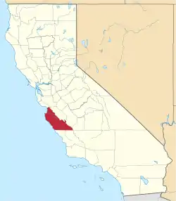 Monterey County map | |
| CDPs | ||
| Unincorporated communities |
| |
| Ghost towns | ||
| Footnotes | ‡This populated place also has portions in an adjacent county | |
| ||
| Authority control |
|---|