Manchester, Monterey County, California
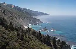
Manchester (sometimes known as Mansfield) was a mining town in the southern Big Sur region of Monterey County, California from about 1875 to 1895. The town was reached by a 20 miles (32 km) road from King City to Jolon, a stage to the Nacimiento River, and a difficult 14 miles (23 km) trail over the steep Santa Lucia Mountains to the site, about 4 miles (6.4 km) inland of Cape San Martin. Prospecting began in the area in the 1850s. In the spring of 1887, after 10 years of various success, William Dugay Cruikshank discovered lode gold at the head of Alder Creek. He opened the Last Chance Mine, later known as the Buclimo Mine.[3] The Last Chance mine produced about $62,000 in gold ore. The mines were not very productive, and most mining activity ceased by about 1895. Renewed attempts at exploiting the ore in the early 1900s failed. Cruickshank lived on the site of the town until his death in 1937.
Manchester
Mansfield, Alder Creek | |
|---|---|
 | |
 Manchester Location in California | |
| Coordinates: 35°52′52″N 121°23′33″W | |
| Country | United States |
| State | California |
| County | Monterey County |
| Elevation | 135 ft (41 m) |
| Population (1889) | |
| • Total | 100 |
| ZIP code | 93920[2] |
| FIPS code | 06-44427 |
History
The history of Manchester is intertwined with the rise and fall of the Los Burros Mining District.[4] The district comprised about 8 square miles (21 km2). It was defined as:[5]
Commencing at the Mouth of the San Kapoko [San Carpoforo Creek] following the Pacific Ocean Northerly to Premits [Prewitts] Trail. Thence following said trail to McKerns. Thence following the Nassimienta [Naciemiento River] to the mouth of the Los Burros Creek. Thence to the place of beginning.
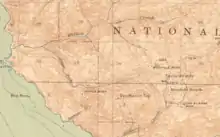
From the rail road in King City, travelers could take a stage 20 miles (32 km) to Jolon. From there an 8 miles (13 km) wagon road was built to the Nacimiento River. To access the mines and the town, there were two trails from the Nacimiento River to the coast, Plaskett/Mansfield Trail to the north and the Los Burros Trail to the south.[6] Over the Lost Burros Trail, it was a 10 miles (16 km) hike to the summit of the Santa Lucia Mountains, followed by a 2 mile downhill trek to the mines. E.S. Harrison, author or "Monterey County", published in 1890, reported that 100 people lived in Manchester.[7]:46 A petition to build a road to the mines was put before the county Board of Supervisors in January 1890, but never advanced.[8]
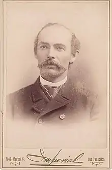
William T. Cruickshank, born in Troy, New York, arrived in California with his father Arnold in 1849. William and his wife Sarah Ann (nee French) were living in Contra Costa County in 1867.[9] Their son William Dugay Cruickshank was born in Fresno County in 1855. The father and son moved to the Manchester area in 1872.[7][9] They searched for gold along with others. At a miner's meeting on February 5, 1875, the Los Burros Mining District was organized. H. C. Dodge was elected Chairman, A.C. Frazier, Secretary, and William T. Cruickshank Recorder.[4] During the next 12 years, 131 mining claims were recorded.[4]
The most valuable gold discovery was made by William Dugay Cruickshank, on March 24, 1887, who called his find the Last Chance mine. The Last Chance mine eventually was 450 feet (140 m) long and dug to a depth of 150 feet (46 m). Cruickshank found five veins which milled at an average of $200 per ton.[7]:84 During the first year of the mining district, 63 claims were recorded. In 1889 the Manchester Mine was dug about 60 feet (18 m) into the mountain; the Melville Mine had a tunnel about 110 feet (34 m)long.[10]
Eventually around 500 claims existed. Many Los Burros mines were registered and renamed, likely filed under several different names. Placer claims were filed along Plaskett Creek, Willow Creek and tributaries, and Alder Creek.[5] Cruikshank, who partnered with James Krinkle, shipped an estimated $62,000 in gold ore from the Last Chance Mine.[11] Since there was no road into the area, the crushed gold ore was sacked and transported on donkeys (hence, los burros) over the Santa Lucia Mountains to the Nacimiento River.
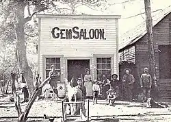
Manchester was built downhill a few hundred yards from the Last Chance mine. In October 1889, a visitor reported "9 or 10 frame houses at Mansfield, among them two boarding houses and four saloons."[12] At its height, several hundred miners lived and worked there. The town had three stamp mills, four stores, five saloons, a dance hall, restaurant, hotel, a barber shop, post office, blacksmith, a small one roomed school, mess halls, bunkhouses, a few cabins, a cemetery, and a dance hall.[13][14] The school was established in July 1890, when Susie R. Bird was hired as its first teacher.[15]
Mining equipment like the ore crushers and stamp mills were brought by ship to Cape San Martin and off-loaded. From there they were hauled on sleds by mules over about 4 miles (6.4 km) over steep, uphill terrain to the mines. Cruickshank built hoisting works and a 10-stamp mill which began operating on November 29, 1889.[16][17]
The Mansfield post office was established in Manchester on September 14, 1889. The name Mansfield was given to the post office because Manchester had already been assigned to another location. The post office closed in 1897. A fire destroyed the town in about 1890. By 1895 the boom had begun to fade.[18]
Another flurry of activity occurred in the early 1900s when placer gold was discovered in gravel and alluvial deposits along various forks of Willow Creek. The entire Willow Creek watershed was prospected, and a large number of pits, shafts, tunnels, open cuts, and adits were explored by miners.[5] Between 1900 and 1909, another 322 claims were filed there.[6] Intermittent small-scale prospecting and development work have continued in the district until the present time. There was a recorded production of several hundred dollars worth of gold in 1953 and again in 1963. It is believed that 2000 or more claims have been located in the district. About 350 people lived in the town at the height of its popularity.[19]
Additional fires over many years have destroyed most traces of the town with the exception of the remnants of the stamp mills. In September 1970, the Buckeye fire burned through most of the Los Burros Mining District, and destroyed nearly all of the remaining miners shacks and cabins. The US Forest Service later destroyed any that remained.[20]
William D. "Billy" Cruickshank went missing while traveling the trail between his cabin in Manchester and Jolon. When it was discovered the 81 year-old man had not been seen since November 16, the sheriff organized a posse on December 15, 1937 to look for him.[21] His body was never found.[22][23] The Cruickshank Trail, Lower Cruickshank Camp, and Upper Cruickshank Camp in the Silver Peak Wilderness are named for William Cruickshank.[24]
Geology
Dark sandstone is most abundant and is also the chief host rock of the gold-bearing deposits. Also present are chert, shale, serpentine, and volcanic rocks. Most of the gold has been recovered from small lenticular ore shoots in oxidized zones near the surface. The sulfides, which consist of fine-grained pyrite and small amounts of chalcopyrite and arsenopyrite generally, are low in gold content. Most of the placer gold has come from Willow Creek, and much of it was concentrated as coarse ragged fragments. Very small amounts have been found in Alder, Plaskett, and Salmon Creeks.[19]
Mineral production
The mining occurred in three nearly parallel quartz veinlets, parallel to a layer of sandstone. The gold was removed via open cuts, shafts, and drift tunnels. The Last Chance reached a maximum depth of 160 feet (49 m). In 1902, large gold nuggets were found on Spruce Creek and placer gold was found in Willow Creek.[3]:326
Ancona, Buclimo $62,000; Bushnell, Gorda, Grizzly, Mariposa, Melville, New York, Plaskett (placer) $18,000; Spruce (placer) $22,000. The value of the total output is estimated to be about $150,000.
References
- "Big Sur". Geographic Names Information System. United States Geological Survey. Retrieved April 16, 2020.
- "ZIP Code(tm) Lookup". United States Postal Service. Retrieved April 16, 2020.
- Hill, James (1923). "Los Burrows District, Monterey County, California" (PDF). Department of the Interior, U.S. Geological Survey. Retrieved 17 April 2020.
- Alderson, Bill. "Gold Mine in Los Burros – Plaskett Highlighted | Plaskett.family". plaskett.family. Retrieved 16 December 2020.
- "Los Burros Mines". losburrosmining.org. Retrieved 15 December 2020.
- Jones, Edward. "Cruikshank & The Last Chance Bonanza". losburrosmining.org. Retrieved 15 December 2020.
- Harrison, Edward Sanford; Stockdale, James T. (1890). Monterey County Illustrated: Resources, History, Biography. Salinas, California: Pacific Press Pub. Co.
- The Californian Board of Supervisors. Salinas, California. January 14, 1890. page 3
- "William T. Cruickshank". FamilySearch. Retrieved 15 December 2020.
- The Californian Los Burros Mines. Salinas, California. June 29, 1889. page 3
- The Californian Real Estate Transactions. Salinas, California. November 21, 1889. page 3
- The Californian Los Burros Mines. Salinas, California. November 21, 1889. page 3
- "Lucia, California Big Sur Coast". www.seecalifornia.com. Retrieved 17 April 2020.
- Henson, Paul; Usner, Donald J. (1996). The Natural History of Big Sur. University of California Press. p. 389. ISBN 978-0-520-20510-9.
- The Californian Los Burros Mines. Salinas, California. July 1, 1890. page 3
- The Californian Los Burros Mines. Salinas, California. November 21, 1889. page 3
- The Californian The Los Burros Mill Stars Up. Salinas, California. December 1, 1889. page 3
- "Manchester - Big Sur - CA - US". Historical Marker Project. Retrieved 17 April 2020.
- "Manchester of the Los Burros - Hobbit Mine". sites.google.com. Retrieved 17 April 2020.
- Jones, Edward. "Manchester of the Los Burros". Retrieved 16 December 2020.
- Salinas Index Journal Co-Discoverer Of Los Burros Gold Field is Missing. Salinas, California. December 15, 1937. page 1
- Salinas Morning Post Disappearance is Recalled. Salinas, California. March 12, 1938. page 10
- Thornton, Stuart. "A dirty journey to the lost city of the Santa Lucias". Monterey County Weekly. Retrieved 17 April 2020.
- "Cruickshank Trail | Silver Peak Wilderness | Big Sur | Hikespeak.com". www.hikespeak.com. Retrieved 15 December 2020.
Municipalities and communities of Monterey County, California, United States | ||
|---|---|---|
| Cities | 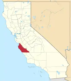 Monterey County map | |
| CDPs | ||
| Unincorporated communities |
| |
| Ghost towns | ||
| Footnotes | ‡This populated place also has portions in an adjacent county | |
| ||