King City, California
King City (variant: Kings City)[9] is a city in Monterey County, California, United States. King City is located on the Salinas River 51 miles (82 km) southeast of Salinas,[9] at an elevation of 335 feet (102 m).[6] It lies along U.S. Route 101 in the Salinas Valley of the Central Coast. King City is a member of the Association of Monterey Bay Area Governments. The population was 12,874 at the 2010 census. It is a small town which has experienced slow economic growth over the past 50 years.
City of King City | |
|---|---|
City | |
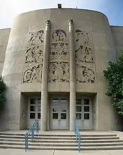 The Robert Stanton Theater at King City High School (1939) | |
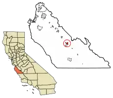 Location of King City in Monterey County, California. | |
 City of King City Location in the United States | |
| Coordinates: 36°12′46″N 121°07′34″W | |
| Country | United States |
| State | California |
| County | Monterey |
| Railway stop | 1886 |
| Incorporated | February 9, 1911[1] |
| Government | |
| • Mayor | Mike LeBarre[2] |
| • State senator | Anna Caballero (D)[3] |
| • Assemblymember | Robert Rivas (D)[3] |
| • U. S. rep. | Jimmy Panetta (D)[4] |
| Area | |
| • Total | 3.95 sq mi (10.24 km2) |
| • Land | 3.87 sq mi (10.02 km2) |
| • Water | 0.09 sq mi (0.22 km2) 3.49% |
| Elevation | 335 ft (102 m) |
| Population | |
| • Total | 12,874 |
| • Estimate (2019)[8] | 14,077 |
| • Density | 3,640.29/sq mi (1,405.50/km2) |
| Time zone | UTC−8 (Pacific) |
| • Summer (DST) | UTC−7 (PDT) |
| ZIP code | 93930 |
| Area code | 831 |
| FIPS code | 06-38520 |
| GNIS feature IDs | 1652734, 2411544 |
| Website | www |
History
The first European land exploration of Alta California, Don Gaspar de Portolá's Spanish expedition, camped on the Salinas River just south of today's King City on September 26, 1769, having followed the route of today's Jolon Road from the south.[10] The land they camped on would later become part of King City.
King City was originally known as Kings City for its founder, Charles King. In 1884 Charles King acquired 13,000 acres (53 km2) of the Mexican land grant Rancho San Lorenzo, originally given to Mariano and Feliciano Soberanes in the early 1840s during Mexican rule of California. King began growing 6,000 acres (24 km2) of wheat. In an effort to get his crop to market, King allowed Southern Pacific Railroad to lay tracks across King Ranch land. The terminus was a station known as King's. (cit)
In 1886 for the Southern Pacific Railroad completed service to King's City to service the farms and ranches in the south Salinas Valley and to transport the goods to San Francisco and Los Angeles.
It was originally called "Hog Town" due to the passel of semi-wild hogs roaming the stubble fields.[11] King wanted to name the town Vanderhurst, after local merchant William Vanderhurst, but was outvoted and it was named for him. The city became known as Kings', then the City of King, and later simply King City.
The King City post office first opened in 1887.[9] Edwards S. Brown, brother-in-law of C.H. King was appointed Postmaster. (cit) King City incorporated under the name "City of King" in 1911.[9]
J. Ernst Steinbeck, father of the novelist John Steinbeck, claimed to have been the first permanent resident of King City. Steinbeck was certainly among the first settlers. He was the first agent for the Southern Pacific Milling Company, which built an early warehouse and flour mill alongside the railroad tracks running through town. The mill was built by R. M. Shackelford, an early California settler and businessman who owned sheep pasturage next to that of Charles King.[12]
Agriculture has always played in role in King City history. Between 1910 and 1930, the city became famous for growing pink beans. King City Pinks were sold around the country, helped along by additional demand during World War I. (cit)
The Robert Stanton Auditorium, built in 1939 as a WPA Depression project, is an example of Art Moderne style, with elliptical rounded corners, Doric-style columns, an expansive curved stairway leading to recessed oak and glass double doors, as well as a bas-relief triptych, by artist Jo Mora, above doors that depict notable multi-cultural scenes of historic importance. Mora's art is incorporated into the building's design both inside and out. In 1991, it was listed on the National Register of Historic Places.
Geography
King City elevation is 330 feet (100 m) above sea level, between Greenfield to the northwest and San Lucas to the southeast, both also on U.S. Route 101. The amount of land area in King City is 3.8 square miles (9.8 km2). The Salinas River flows on the west side of the city; due to its sandy bed, portions of the river sometimes flow underground, especially during the summer months.[10]
Climate
King City has a semi-arid climate (Bsk), although bordering on a Mediterranean climate (Csb), with very warm, mostly dry summers and cool, wet winters. The average January temperatures are a maximum of 64.1 °F (17.8 °C) and a minimum of 34.9 °F (1.6 °C). The average July temperatures are a maximum of 86.9 °F (30.5 °C) and a minimum of 51.0 °F (10.6 °C). There are an average of 50.6 days with highs of 90 °F (32 °C) or higher and an average of 49.7 days with lows of 32 °F (0 °C) or lower. The record high temperature was 120 °F (49 °C) on June 24, 1925. The record low temperature was 10 °F (−12 °C) on January 6, 1904.
Average annual precipitation is 11.24 inches (285 mm). There are an average of 40 days with measurable precipitation. The driest year was 1953 with 3.14 inches (80 mm). The most precipitation in one month was 10.50 inches (267 mm) in February 1998. The most precipitation in 24 hours was 3.72 inches (94 mm) on January 18, 1914. Although snow often falls in the winter in the Santa Lucia mountains west of the city, it is quite rare in the Salinas Valley; however, 5.3 inches (130 mm) fell in January 1957 and 3.0 inches (76 mm) fell in December 1954.[11] The low humidity in the area contributes to freezing temperatures at night, and intense temperatures during daylight.
| Climate data for King City, California (1981–2010 normals, extremes 1926-present) | |||||||||||||
|---|---|---|---|---|---|---|---|---|---|---|---|---|---|
| Month | Jan | Feb | Mar | Apr | May | Jun | Jul | Aug | Sep | Oct | Nov | Dec | Year |
| Record high °F (°C) | 86 (30) |
90 (32) |
93 (34) |
104 (40) |
108 (42) |
112 (44) |
111 (44) |
113 (45) |
115 (46) |
109 (43) |
95 (35) |
91 (33) |
115 (46) |
| Average high °F (°C) | 63.0 (17.2) |
65.6 (18.7) |
69.4 (20.8) |
73.9 (23.3) |
78.5 (25.8) |
82.7 (28.2) |
85.0 (29.4) |
85.3 (29.6) |
84.8 (29.3) |
79.3 (26.3) |
69.0 (20.6) |
62.1 (16.7) |
74.9 (23.8) |
| Average low °F (°C) | 37.0 (2.8) |
39.6 (4.2) |
41.6 (5.3) |
43.0 (6.1) |
46.9 (8.3) |
50.1 (10.1) |
52.8 (11.6) |
52.7 (11.5) |
50.6 (10.3) |
45.9 (7.7) |
40.0 (4.4) |
36.4 (2.4) |
44.7 (7.1) |
| Record low °F (°C) | 15 (−9) |
19 (−7) |
22 (−6) |
24 (−4) |
31 (−1) |
36 (2) |
34 (1) |
31 (−1) |
32 (0) |
23 (−5) |
20 (−7) |
14 (−10) |
14 (−10) |
| Average precipitation inches (mm) | 2.34 (59) |
2.51 (64) |
2.20 (56) |
0.78 (20) |
0.31 (7.9) |
0.05 (1.3) |
0.01 (0.25) |
0.01 (0.25) |
0.18 (4.6) |
0.63 (16) |
1.13 (29) |
1.95 (50) |
12.10 (307) |
| Average precipitation days (≥ 0.01 in) | 8.0 | 8.6 | 7.6 | 4.6 | 2.0 | 0.4 | 0.1 | 0.2 | 0.8 | 2.3 | 5.0 | 8.1 | 47.7 |
| Source: NOAA [12] | |||||||||||||
Transportation
King City is served by Amtrak Thruway Motorcoach as the passenger train that passes through the community does not stop.[13] In 2018, King City was denied a $21 million TIRCP grant to build a multimodal transportation center which would provide connections to Amtrak, in between Paso Robles and Salinas. City officials have said they will apply again in the future.[14] A small $1.5 million grant was approved by the state government the following year, providing funds to design the Amtrak platform.[15]
Demographics
| Historical population | |||
|---|---|---|---|
| Census | Pop. | %± | |
| 1890 | 253 | — | |
| 1920 | 1,048 | — | |
| 1930 | 1,483 | 41.5% | |
| 1940 | 1,768 | 19.2% | |
| 1950 | 2,347 | 32.7% | |
| 1960 | 2,937 | 25.1% | |
| 1970 | 3,717 | 26.6% | |
| 1980 | 5,495 | 47.8% | |
| 1990 | 7,634 | 38.9% | |
| 2000 | 11,094 | 45.3% | |
| 2010 | 12,874 | 16.0% | |
| 2019 (est.) | 14,077 | [8] | 9.3% |
| U.S. Decennial Census[16] | |||
2010
At the 2010 census King City had a population of 12,874. The population density was 3,231.8 people per square mile (1,247.8/km2). The racial makeup of King City was 6,173 (47.9%) White, 150 (1.2%) African American, 347 (2.7%) Native American, 172 (1.3%) Asian, 8 (0.1%), Pacific Islander, 5,451 (42.3%) from other races, and 573 (4.5%) from two or more races. Hispanic or Latino of any race were 11,266 persons (87.5%).[17]
The census reported that 12,815 people (99.5% of the population) lived in households, no one lived in non-institutionalized group quarters and 59 (0.5%) were institutionalized.
There were 3,008 households, 1,852 (61.6%) had children under the age of 18 living in them, 1,823 (60.6%) were opposite-sex married couples living together, 386 (12.8%) had a female householder with no husband present, 272 (9.0%) had a male householder with no wife present. There were 188 (6.3%) unmarried opposite-sex partnerships, and 21 (0.7%) same-sex married couples or partnerships. 412 households (13.7%) were one person and 186 (6.2%) had someone living alone who was 65 or older. The average household size was 4.26. There were 2,481 families (82.5% of households); the average family size was 4.47.
The age distribution was 4,374 people (34.0%) under the age of 18, 1,819 people (14.1%) aged 18 to 24, 3,937 people (30.6%) aged 25 to 44, 1,984 people (15.4%) aged 45 to 64, and 760 people (5.9%) who were 65 or older. The median age was 25.9 years. For every 100 females, there were 115.7 males. For every 100 females age 18 and over, there were 119.3 males.
There were 3,218 housing units at an average density of 807.8 per square mile, of the occupied units 1,394 (46.3%) were owner-occupied and 1,614 (53.7%) were rented. The homeowner vacancy rate was 3.2%; the rental vacancy rate was 3.4%. 5,586 people (43.4% of the population) lived in owner-occupied housing units and 7,229 people (56.2%) lived in rental housing units.
2000
At the 2000 census there were 11,094 people in 2,736 households, including 2,251 families, in the city. The population density was 3,030.0 people per square mile (1,170.3/km2). There were 2,822 housing units at an average density of 770.8 per square mile (297.7/km2). The racial makeup of the city was 42.09% White, 0.59% Black or African American, 1.05% Native American, 1.23% Asian, 0.14% Pacific Islander, 50.46% from other races, and 4.46% from two or more races. 80.42% of the population were Hispanic or Latino of any race.[18] Of the 2,736 households 54.6% had children under the age of 18 living with them, 62.2% were married couples living together, 12.4% had a female householder with no husband present, and 17.7% were non-families. 13.5% of households were one person and 6.0% were one person aged 65 or older. The average household size was 4.03 and the average family size was 4.28.
The age distribution was 35.7% under the age of 18, 13.7% from 18 to 24, 31.2% from 25 to 44, 13.3% from 45 to 64, and 6.2% 65 or older. The median age was 25 years. For every 100 females, there were 115.8 males. For every 100 females age 18 and over, there were 119.6 males.
The median annual income for a household in the city was $34,398 and the median annual income for a family was $33,750. Males had a median annual income of $27,377 versus $25,286 for females. The per capita annual income for the city was $11,685. About 16.9% of families and 20.8% of the population were below the poverty line, including 23.5% of those under age 18 and 17.1% of those age 65 or over.
Media
- See also: Media in Monterey County
Radio and television
Local radio stations include KEXA-FM – 93.9, KRKC-AM – 1490, 102 KRKC-FM, and KDON-FM 102.5. Television service for the community comes from the Monterey–Salinas–Santa Cruz designated market area (DMA).
Newspapers
Local newspapers include the Gannett-owned Salinas Californian and the town's own weekly, The King City Rustler.
The Rustler was founded in 1901 by Fred Vivian, who reportedly went into a local barber shop, sold subscriptions to all the customers and then passed around a hat for them to suggest names for the newspaper. "The Rustler" was the one he drew out.
Vivian was later succeeded as publisher by his grandson Harry Casey, who was called home to King City in 1952 to take over management of the newspaper by his aunt Ruth Steglich after the death of her husband, then-publisher Bill Steglich. He served as co-publisher until Ruth Steglich's death and publisher until declining health forced him to sell The Rustler and three other regional weeklies to News Media, Inc. in 1995.
Casey, whose sons Rich and Bill still operate Casey Printing in King City, died in 1998. Both he and Vivian are members of the California Newspaper Hall of Fame.
In popular culture
The town features prominently in the song "Queen of King City", on the Red Meat album We Never Close.
King City is also mentioned repeatedly in John Steinbeck's novel East of Eden. The book is principally set in the surrounding Salinas Valley.
King City is revealed to be the home town of The Man in the Tan Jacket in the novel Welcome to Night Vale, and the town is a major part of the plot.
Film shot in King City
- 1972: The Candidate [19]
Notable people
- Eldon Dedini, cartoonist
- George Taylor Morris (1947–2009), radio host[20]
- Jim Mankins (1944-2004), King City High School running back who played for Oklahoma and Florida State
See also
References
- "California Cities by Incorporation Date". California Association of Local Agency Formation Commissions. Archived from the original (Word) on November 3, 2014. Retrieved August 25, 2014.
- "Mayor & City Council". King City. Retrieved October 8, 2014.
- "California Electoral Districts". UC Regents. Archived from the original on February 1, 2015. Retrieved October 8, 2014.
- "California's 20th Congressional District - Representatives & District Map". Civic Impulse, LLC. Retrieved September 24, 2014.
- "2019 U.S. Gazetteer Files". United States Census Bureau. Retrieved July 1, 2020.
- U.S. Geological Survey Geographic Names Information System: King City, California
- "King City (city) QuickFacts". United States Census Bureau. Archived from the original on February 23, 2015. Retrieved February 23, 2015.
- "Population and Housing Unit Estimates". United States Census Bureau. May 24, 2020. Retrieved May 27, 2020.
- Durham, David L. (1998). California's Geographic Names: A Gazetteer of Historic and Modern Names of the State. Clovis, Calif.: Word Dancer Press. p. 911. ISBN 1-884995-14-4.
- The Salinas, Upside-down River by Anne B. Fisher (New York: Farrar & Rinehart, Inc., 1945)
- "King City, California – Climate Summary". www.wrcc.dri.edu. Retrieved October 27, 2017.
- "NowData - NOAA Online Weather Data". National Oceanic and Atmospheric Administration. Retrieved March 3, 2012.
- Hicks, Mariana (December 8, 2017). "King City, Soledad included in state rail plan". KION. Retrieved September 17, 2019.
- https://www.tamcmonterey.org/wp-content/uploads/2018/01/King-City-TIRCP-Application-Submittal3801.pdf
- Cronk, Ryan (March 7, 2019). "King City train station becoming reality after state approves $1.5M for project". King City Rustler. Retrieved March 7, 2019.
- "Census of Population and Housing". Census.gov. Retrieved June 4, 2015.
- "2010 Census Interactive Population Search: CA - King City city". U.S. Census Bureau. Archived from the original on July 15, 2014. Retrieved July 12, 2014.
- "U.S. Census website". United States Census Bureau. Retrieved January 31, 2008.
- Internet Movie Database
- Holley, Joe. "George Taylor Morris, 62: Radio Host Played Classic Rock", The Washington Post, August 3, 2009. Accessed August 10, 2009.
External links
| Wikimedia Commons has media related to King City, California. |
| Wikivoyage has a travel guide for King City. |
Municipalities and communities of Monterey County, California, United States | ||
|---|---|---|
| Cities |  Monterey County map | |
| CDPs | ||
| Unincorporated communities |
| |
| Ghost towns | ||
| Footnotes | ‡This populated place also has portions in an adjacent county | |
| ||
| Authority control |
|---|