Soledad, California
Soledad is a city in Monterey County, California, United States.[6] Soledad is located 25 miles (40 km) southeast of Salinas,[9] at an elevation of 190 feet (58 m).[6] The population was 25,738 at the 2010 census.
Soledad, California | |
|---|---|
City | |
| City of Soledad | |
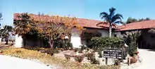
.jpg.webp) .jpg.webp) 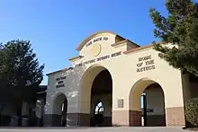 Clockwise: Mission Nuestra Señora de la Soledad; Soledad High School; Mission Nuestra Señora de la Soledad | |
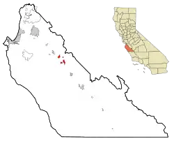 Location in Monterey County and the state of California | |
 Soledad, California Location in the United States  Soledad, California Soledad, California (California) | |
| Coordinates: 36°25′29″N 121°19′35″W | |
| Country | United States |
| State | California |
| County | Monterey |
| Incorporated | March 9, 1921[1] |
| Government | |
| • Mayor | Fred J. Ledesma[2] |
| • State senator | Anna Caballero (D)[3] |
| • Assemblymember | Robert Rivas (D)[3] |
| • U. S. rep. | Jimmy Panetta (D)[4] |
| Area | |
| • Total | 4.63 sq mi (12.00 km2) |
| • Land | 4.48 sq mi (11.61 km2) |
| • Water | 0.15 sq mi (0.39 km2) 3.32% |
| Elevation | 190 ft (58 m) |
| Population | |
| • Total | 25,738 |
| • Estimate (2019)[8] | 25,999 |
| • Density | 5,802.05/sq mi (2,240.20/km2) |
| Time zone | UTC-8 (Pacific) |
| • Summer (DST) | UTC-7 (PDT) |
| ZIP code | 93960 |
| Area code | 831 |
| FIPS code | 06-72520 |
| Website | www |
The town is located near the Spanish mission, Mission Nuestra Señora de la Soledad (the mission of Our Lady of Solitude), founded on October 9, 1791, by Fermín Francisco de Lasuén, as the 13th of 21 missions in California. The town's name comes from the mission.
Soledad is seated at the heart of one of the most economically productive and technologically advanced agricultural regions in the world; hence, the Salinas Valley name, "Salad Bowl of the World." Agricultural companies working out of this region include Dole Fresh Vegetables, Tanimura & Antle Fresh Foods, Taylor Farms, D'Arrigo Brothers Inc., Mann Packing Inc., Merrill Farms and Braga Farms.
Soledad is located in one of the primary wine grape-growing regions of California with over twenty vineyards and wineries within a thirty-mile radius, several of which have tasting rooms and offer a wide selection of wines for sale. Some of the vineyards and wineries located nearby are Chalone, Scheid, Paraiso Vineyards, Pisoni Vineyards, Hahn Estate, San Saba, J. Lohr, Kendall-Jackson, Ventana, Hess Select, Estancia, The Michaud Vineyard and Graff Family Vineyards.
History
The original community of Soledad was established as a Spanish mission on October 9, 1791, by Fermín Lasuén, and founded under the rule of the Viceroyalty of New Spain (Virreinato de Nueva España) 1535 to 1821.
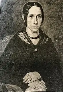
The town of Soledad was founded by Catalina Munras, at the wishes of her dying husband Don Esteban Munras. Don Esteban had arrived in the area in 1820 and was granted Rancho San Vicente from Mexico after it gained its independence from Spain. Following her late husband's dream and advice, she selected “poor land, no good for tilling, a town to help all rancheros around. One lot for a school, one for a church, and one for a cemetario where God would give rest to his workers.” The decision to found the town had some judicious timing, since the Southern Pacific Railroad was stretching down the Salinas Valley by 1872. She granted a right-of-way to Southern Pacific Railroad which was the end of its line in the Salinas Valley for 13 years, providing shipping services for grains and products from the area.
The Township of Soledad was created by the Monterey County Board of Supervisors on February 6, 1876 upgrading the settlement to a town. The Soledad post office opened in 1869.[9] The community of Soledad in 1874 had a few buildings and shops. The two main streets were named Front and Main.
San Vicente School was built in 1913 forming the Soledad School District. The City, a general law city, incorporated in March 1921[9] with a City Council/City Manager form of government. The city's name comes from the mission Mission Nuestra Señora de la Soledad.[9]
Los Coches Adobe
The Los Coches Adobe was given to Maria Josefa Soberanes. She married William Richardson and they built the adobe in 1843. It was a working rancho until 1846 when the United States waged war with Mexico to gain control of California. Capt. John C. Fremont and his troops camped there after the Battle of Natividad. Poor guests, they Richardsons, out of house and home and never paid for it. In the mid-1850s, it was a stop on the San Juan Bautista-Soledad stage line and then became a popular inn on the Butterfield Overland Stage route running between San Francisco and Los Angeles. When the Southern Pacific Railroad tracks finally reached Soledad in 1872, the area became a popular stopover for travelers and a place to stay before getting on a Coast Line Stage Company coach for the trip south to Los Angeles.
The demise of the Rancho was caused by the drought that took hold of the valley in the early 1860s. Its severity was devastating to the ranchero lifestyle and it systematically brought that period of history to a close in the Valley. Land was sold at bargain prices to entrepreneurial Americans who changed the landscape from pastoral to agricultural. David Jacks, one of the Valley's early enterprising residents purchased Rancho Los Coches in 1865.
Margaret Jacks, daughter of David Jacks, donated the adobe and 10 acres of land to the State of California and the granddaughter of William B. Richardson, Adeline Richardson O’Brien, donated a marker identifying her ancestral home.
Fort Romie
In 1898 Fort Romie was founded a few miles north of the mission and west of the city. It was one of three Salvation Army Colonies established in America. The name honors Charles Romie, a landowner who sold the land to the Salvation Army. They included Fort Amity in Colorado, Fort Herrick in Ohio and the Fort Romie Colony on Romie's Ranchita land. The Salvation Army goal was to take poor families from the cities and bring them back to nature so that their lives would be improved. The Salvation Army sought people who had some knowledge of farming. Each family had 10 acres. A family with two children had a two roome house, those with three or more children had a four-room house. Everything was furnished to the settlers without charge: seed, sheds, tools equipment were provided by the Salvation Army for all to use. In return they contracted to make yearly payments of $100 for 10 years, after which they would own the land.
Paraiso Springs
Located just west of Soledad is the Paraiso Hot Springs. It was used by the Native Americans and the Mission Padres. In the late 1800s and early 1900s it was a popular resort for people taking the railroad from San Francisco to Soledad and then by stage to Paraiso Springs. In 1905, the manager billed the resort as, "Hot soda and sulfur plunge and tub baths with first class masseurs in attendance. Charming climate, grand scenery and flower sin profusion. Stage meets afternoon train at Soledad and carries you over famous Salinas Valley good roads, a distance of only eight miles."[10]
Soledad is used as a backdrop in John Steinbeck's 1937 novel Of Mice and Men, a novella about the unusual friendship of two men who find work on a farm in the Salinas Valley. Soledad was chosen as the setting because soledad is Spanish for 'solitude', a recurring motif in the story.
Soledad has been rocked by the great 1906 San Francisco earthquake and the Loma Prieta earthquake in 1989.
The Soledad Prison was three miles (5 km) north of the city until annexed in 1992. It was built in 1946.
In May 1996 the Salinas Valley State Prison was opened at a cost of $236 million.
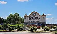
Soledad's slogan was "It's happening in Soledad" was used until 2013 when "Gateway to the Pinnacles" was introduced.
Geography
Soledad is located at 36°25′29″N 121°19′35″W.[6]
According to the United States Census Bureau, the city has a total area of 4.6 square miles (12 km2), 96.68% of it land and 3.32% of it water.
Soledad is about six miles (10 km) southwest of Pinnacles National Park, nestled among the nearby Gabilan Mountains.
Climate
This region experiences warm (but not hot) and dry summers, with no average monthly temperatures above 71.6 °F. According to the Köppen Climate Classification system, Soledad has a warm-summer Mediterranean climate, abbreviated "Csb" on climate maps.[11]
Transportation
Soledad is located on U.S. Route 101 and is accessible via northbound and southbound exit ramps on Front Street, at the north and south ends of town. It is the western terminus of California State Route 146, which connects the city to nearby Pinnacles National Park.
Soledad is serviced by the Monterey-Salinas Transit line 23 (Salinas – King City). As of September 5, 2009, the bus stops in Soledad are located at the correctional facility, Front & San Vicente and Monterey & East.[12]
Demographics
| Historical population | |||
|---|---|---|---|
| Census | Pop. | %± | |
| 1880 | 136 | — | |
| 1890 | 217 | 59.6% | |
| 1930 | 594 | — | |
| 1940 | 861 | 44.9% | |
| 1950 | 2,441 | 183.5% | |
| 1960 | 2,837 | 16.2% | |
| 1970 | 4,222 | 48.8% | |
| 1980 | 5,928 | 40.4% | |
| 1990 | 7,146 | 20.5% | |
| 2000 | 11,263 | 57.6% | |
| 2010 | 25,738 | 128.5% | |
| 2019 (est.) | 25,999 | [8] | 1.0% |
| U.S. Decennial Census[13] | |||
2000
As of the census[14] of 2000, there were 11,263 people, 2,472 households, and 2,242 families residing in the city. The population density was 2,680.0 inhabitants per square mile (1,035.4/km2). There were 2,534 housing units at an average density of 603.0/mi2 (232.9/km2). The racial makeup of the city was 31.90% White, 1.15% African American, 1.73% Native American, 2.35% Asian, 0.08% Pacific Islander, 58.56% from other races, and 4.23% from two or more races. Hispanic or Latino of any race were 86.82% of the population.
There were 2,472 households, out of which 60.2% had children under the age of 18 living with them, 69.9% were married couples living together, 13.8% had a female householder with no husband present, and 9.3% were non-families. 7.2% of all households were made up of individuals, and 3.7% had someone living alone who was 65 years of age or older. The average household size was 4.54 and the average family size was 4.58.
In the city, the population was spread out, with 36.7% under the age of 18, 12.9% from 18 to 24, 31.4% from 25 to 44, 13.1% from 45 to 64, and 5.9% who were 65 years of age or older. The median age was 25 years. For every 100 females, there were 108.0 males. For every 100 females age 18 and over, there were 106.6 males.
The median income for a household in the city was $42,602, and the median income for a family was $41,188. Males had a median income of $31,566 versus $23,964 for females. The per capita income for the city was $11,442. About 16.3% of families and 18.4% of the population were below the poverty line, including 25.1% of those under age 18 and 9.2% of those age 65 or over.
2010
The 2010 United States Census[15] reported that Soledad had a population of 25,738. The population density was 5,637.5 people per square mile (2,176.7/km2). The racial makeup of Soledad was 12,625 (49.1%) White, 2,945 (11.4%) African American, 367 (1.4%) Native American, 757 (2.9%) Asian, 103 (0.4%) Pacific Islander, 8,189 (31.8%) from other races, and 752 (2.9%) from two or more races. Hispanic or Latino of any race were 18,308 persons (71.1%).
The Census reported that 15,635 people (60.7% of the population) lived in households, 0 (0%) lived in non-institutionalized group quarters, and 10,103 (39.3%) were institutionalized.
There were 3,664 households, out of which 2,471 (67.4%) had children under the age of 18 living in them, 2,387 (65.1%) were opposite-sex married couples living together, 586 (16.0%) had a female householder with no husband present, 291 (7.9%) had a male householder with no wife present. There were 224 (6.1%) unmarried opposite-sex partnerships, and 30 (0.8%) same-sex married couples or partnerships. 301 households (8.2%) were made up of individuals, and 123 (3.4%) had someone living alone who was 65 years of age or older. The average household size was 4.27. There were 3,264 families (89.1% of all households); the average family size was 4.41.
The population was spread out, with 5,674 people (22.0%) under the age of 18, 2,455 people (9.5%) aged 18 to 24, 10,126 people (39.3%) aged 25 to 44, 6,296 people (24.5%) aged 45 to 64, and 1,187 people (4.6%) who were 65 years of age or older. The median age was 34.9 years. For every 100 females, there were 235.5 males. For every 100 females age 18 and over, there were 301.8 males.
There were 3,876 housing units at an average density of 849.0 per square mile (327.8/km2), of which 2,092 (57.1%) were owner-occupied, and 1,572 (42.9%) were occupied by renters. The homeowner vacancy rate was 2.4%; the rental vacancy rate was 4.1%. 8,642 people (33.6% of the population) lived in owner-occupied housing units and 6,993 people (27.2%) lived in rental housing units.
The mean household income within the Soledad city limits was $58,841, and the median household income was $44,343. Roughly 7.8% of households were below the poverty line.
Socioeconomically, 31.8% of Soledad's households were considered upper middle income to upper income while 45.8% were considered lower middle income to upper middle income. Roughly 22.4% of households were considered lower income.
Media
Television service for the community comes from the Monterey-Salinas-Santa Cruz designated market area (DMA). Radio stations Monterey-Salinas-Santa Cruz area of dominant influence (ADI) or continuous measurement market (CMM). Local newspapers include the Monterey County Herald, Salinas Californian and Soledad Bee.
Soledad is also the setting of the story in John Steinbeck's novel, Of Mice and Men.
In a 2013 Safe Cities report, Soledad was rated California's eleventh-safest city. Soledad was highly regarded for its sense of community and high amount of volunteerism. The 50 Safest Cities in California
Soledad was also rated the ninety-fourth-safest city out of one hundred cities nationwide in a 2014 Neighborhood Scout Report.[16]
In popular culture
In July 2015, Ghost Adventures filmed an episode for three days at the infamously haunted Los Coches adobe. The city is hoping it will create national attention and could be made into a tourist destination. The episode aired September 26, 2015. [17]
Economy
Although Soledad is known for its agriculture, it was once the home of timber production. Soledad was home to the Sequoia Forest Industries sawmill. It was closed in 1991 and approximately 91 jobs were lost due to the closure of the mill. The warehouse is still in the city as a reminder of past industrial opportunities the small town had to offer.
Agriculture
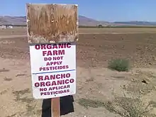
Land for agriculture is Soledad's most abundant natural resource. Soledad's farmland is considered "Prime Farmland", meaning that the soils around and near the city have some of the best physical and chemical characteristics for farming. Due to this fact great efforts in conserving farmland are a very high priority for the city. Prime farmland is the backbone of the Soledad economy. Future planning will consider the effect of urban sprawl amongst the farmlands. Class I, II, and III soils are the most valuable to farming. The climate also allows for year-round crops.
Although Soledad has great soil for salad green crops, it also has a large presence of vineyards and wineries in the valley and foothills. Some famous wineries include Chalone Vineyard, Paraiso Springs Vineyards, Hahn Estate Winery, Zabala Vineyards, Richard Boyer Wines, and Ventana Vineyards. It was once the home of the Paul Masson Winery which is now closed.
Dole Food Company maintains a plant in Soledad. Opened in 1994, it is touted as being the "world's largest pre-cut salad plant."[18]
As of 2007, Soledad features a weekly certified Farmers' Market on Soledad St.[19]
Energy
Soledad is home to the Soledad Energy Partnership, operators of a wood-waste burning electric power plant. This 13.5 megawatt facility was restarted in July 2001 after a six-year shut-down due to termination of a PG&E purchase agreement. The plant was recommissioned during the California electricity crisis.
As of mid-2006, the plant was again closed.
Several violations at the plant have been issued by the California Integrated Water Quality System Project. The plant was issued violations from 2002 to 2006 for various reporting and pollution allegations.
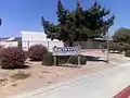
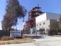 Soledad power plant.
 Soledad power plant.
Schools
There are two school districts in the Soledad area: Soledad Unified School District & Mission Union School District
SUSD
- San Vicente Elementary, Established 1913
- Frank Ledesma Elementary, Established 2004
- Jack Franscioni Elementary,Established 2006
- Gabilan Elementary, Established 1980
- Rose Ferrero Elementary, Established 2001 – with 24 classes.
- Main St. Middle school, Home of the Trojans, Established 1908
- Soledad High School, Home of the Aztecs, Established 1999
- Chalone Alternative School-now closed.
- Pinnacles Continuation High School
- Soledad Adult School
- Mission Trails Regional Occupation Program
MUSD
- Mission Union School, Home of the Padres, Established 1905
 San Vicente School
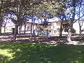 Gabilan School
Prisons
The city has two separate correctional facilities in the northernmost part of the city. The first and oldest prison is Soledad CTF (Correctional Training Facility) built in 1946. It was also one of the first 12 prisons of the California Department of Corrections and Rehabilitation. The other one is Salinas Valley State Prison, which opened in 1996.
Recreation
- See also: Monterey county attractions
- Pinnacles National Park. Hiking and rock climbing
- The Pinnacles Wine Festival
- Arroyo Seco (Monterey) County
- The Salinas River
- Soledad YMCA
- Soledad Mission. Mission Nuestra Señora de la Soledad
- Vosti Park
- Soledad Swimming Pool. Home of the Soledad Sharks swimming team.
- Little League Field
- Front Street Park
- Peverini Park
- Gene Martin Stadium, Home of Soledad Football and Aztec Soccer
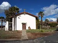 Mission Nuestra Señora de la Soledad is one of the town's famous attractions
See also
References
- "California Cities by Incorporation Date". California Association of Local Agency Formation Commissions. Archived from the original (Word) on November 3, 2014. Retrieved August 25, 2014.
- "City Council". City of Soledad. Retrieved March 15, 2015.
- "Statewide Database". UC Regents. Archived from the original on February 1, 2015. Retrieved December 8, 2014.
- "California's 20th Congressional District - Representatives & District Map". Civic Impulse, LLC. Retrieved September 24, 2014.
- "2019 U.S. Gazetteer Files". United States Census Bureau. Retrieved July 1, 2020.
- "Soledad". Geographic Names Information System. United States Geological Survey. Retrieved March 15, 2015.
- "Soledad (city) QuickFacts". United States Census Bureau. Archived from the original on March 29, 2015. Retrieved March 24, 2015.
- "Population and Housing Unit Estimates". United States Census Bureau. May 24, 2020. Retrieved May 27, 2020.
- Durham, David L. (1998). California's Geographic Names: A Gazetteer of Historic and Modern Names of the State. Clovis, Calif.: Word Dancer Press. p. 961. ISBN 1-884995-14-4.
- Clovis, Margaret (2005). Salinas Valley. Images of America. p. 60. ISBN 978-0-7385-3048-2.
- "Soledad, California Köppen Climate Classification (Weatherbase)". Weatherbase.com. Retrieved August 12, 2018.
- "Monterey-Salinas Transit". Mst.org. Retrieved August 12, 2018.
- "Census of Population and Housing". Census.gov. Retrieved June 4, 2015.
- "U.S. Census website". United States Census Bureau. Retrieved January 31, 2008.
- "2010 Census Interactive Population Search: CA – Soledad city". U.S. Census Bureau. Archived from the original on July 15, 2014. Retrieved July 12, 2014.
- "2014 Top 100 Safest Cities". Neighborhoodscout.com. January 5, 2014. Retrieved March 17, 2014.
- Whittaker, Brynne (July 15, 2015). "Ghosthunters film episode at Soledad adobe". M.ksbw.com. Retrieved August 12, 2018.
- "Dole Company History". Dole.com. Archived from the original on November 18, 2007. Retrieved August 12, 2018.
- "CDFA Certified Farmers' Markets". Cdfa.ca.gov. Retrieved August 12, 2018.
External links
| Wikimedia Commons has media related to Soledad, California. |
| Wikivoyage has a travel guide for Soledad. |
Municipalities and communities of Monterey County, California, United States | ||
|---|---|---|
| Cities | 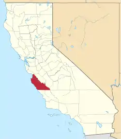 Monterey County map | |
| CDPs | ||
| Unincorporated communities |
| |
| Ghost towns | ||
| Footnotes | ‡This populated place also has portions in an adjacent county | |
| ||
| Authority control |
|---|