Moncton Parish, New Brunswick
Moncton is a civil parish in Westmorland County, New Brunswick, Canada.[2]
Moncton | |
|---|---|
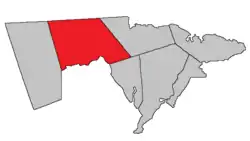 Location within Westmorland County, New Brunswick. | |
| Coordinates: 46.775555°N 65.48°W | |
| Country | |
| Province | |
| County | Westmorland County |
| Erected | 1786 |
| Area | |
| • Land | 579.63 km2 (223.80 sq mi) |
| Population (2016)[1] | |
| • Total | 9,811 |
| • Density | 16.9/km2 (44/sq mi) |
| • Change 2011-2016 | |
| • Dwellings | 4,036 |
| Time zone | UTC-4 (AST) |
| • Summer (DST) | UTC-3 (ADT) |
For governance purposes it is divided between the cities of Dieppe and Moncton; the Indian reserves of Metepenagiag 3 Urban Reserve, Metepenagiag 8 Urban Reserve, and Soegao 35; and the local service district of the parish of Moncton,[3] which further includes the special service areas of Calhoun Road, Greater Lakeburn, Irishtown, and Painsec Junction.
All governance units except the Indian reserves are members of the Southeast Regional Service Commission.[4]
Origin of name
The parish was named in honour of Robert Monckton,[5] the British commander who captured Fort Beauséjour and oversaw the Expulsion of the Acadians.
History
Moncton was established in 1765 as Monckton Township in the province of Nova Scotia.[6]
In 1786 Moncton Parish was erected as one of the province's original parishes,[7] using the same boundaries as Monckton Township. The northern corner of the parish extended past the northern line of Westmorland County.[8]
In 1835 all of Dorchester Parish north of the mouth of Fox Creek was transferred to Moncton.[9]
In 1850 the western boundary was changed to match the prolongation of the eastern line of a large grant straddling the Petitcodiac River, adding part of Salisbury Parish.[10]
In 1894 the boundary with Dorchester Parish was altered slightly, adding territory to Moncton.[11] The boundaries of the parish were made retroactive to its erection.
Delineation
Moncton Parish is defined in the Territorial Division Act[2] as being bounded:
- East by Shediac Parish; north by the County line, west by that part of the east line of the grant to Martin Gay and associates, which lies north of Petitcodiac River; and the northerly prolongation thereof, to the County line; southerly by the Petitcodiac River and Dorchester Parish.
Communities
Parish population total does not include incorporated municipalities (in bold).
|
|
|
Demographics
Population
|
LanguageMother tongue (2016)[1]
| |||||||||||||||||||||||||||||||||||||||
Access routes
Highways and numbered routes that run through the parish, including external routes that start or finish at the parish limits:[15]
See also
References
- "Census Profile, 2016 Census: Moncton, Parish [Census subdivision], New Brunswick". Statistics Canada. Retrieved October 5, 2019.
- "Chapter T-3 Territorial Division Act". Government of New Brunswick. Retrieved 13 November 2020.
- "New Brunswick Regulation 84-168 under the Municipalities Act (O.C. 84-582)". Government of New Brunswick. Retrieved 23 July 2020.
- "Communities in each of the 12 Regional Service Commissions (RSC) / Les communautés dans chacune des 12 Commissions de services régionaux (CSR)" (PDF), Government of New Brunswick, July 2017, retrieved 1 February 2021
- Ganong, William F. (1896). A Monograph of the Place-Nomenclature of the Province of New Brunswick. Royal Society of Canada. p. 254.
- Ganong, William F. (1899). A Monograph of Historic Sites in the Province of New Brunswick. Royal Society of Canada. p. 335.
- "26 Geo. III Chapter I. An Act for the better ascertaining and confirming the Boundaries of the several Counties within this Province, and for subdividing them into Towns or Parishes.". Acts of the General Assembly of His Majesty's Province of New-Brunswick, passed in the year 1786. Saint John, New Brunswick: Government of New Brunswick. 1786. pp. 3–12.
- Ganong, William F. (1901). A Monograph of the Evolution of the Boundaries of the Province of New Brunswick. Royal Society of Canada. p. Map No. 35.
- "5 Wm. IV c. 15 An Act to alter the boundary line between certain Parishes in the County of Westmorland.". Acts of the General Assembly of His Majesty's Province of New-Brunswick, Passed in the Year 1835. Fredericton: Government of New Brunswick. 1835. p. 27.
- "13 Vic. c. 51 An Act to consolidate all the Laws now in force for the division of the Province into Counties, Towns and Parishes.". Acts of the General Assembly of Her Mjaesty's Province of New Brunswick, Passed in the Year 1850. Fredericton: Government of New Brunswick. 1850. pp. 142–152, 145–149. Book was poorly proofread, resulting in title typo and reuse of page numbers 145–152.
- "57 Vic. c. 36 An Act to amend Chapter 2 of the Consolidated Statutes, of 'The division of the Province into Counties, Towns and Parishes,' so far as relates to the County of Westmorland.". Acts of the General Assembly of Her Majesty's Province of New Brunswick. Passed in the Month of April, 1894. Fredericton: Government of New Brunswick. 1894. pp. 162–163.
- Statistics Canada: 2001, 2006 census
- "2006 Community Profile: Moncton Parish, New Brunswick". Statistics Canada. Retrieved October 5, 2019.
- 2011 Statistics Canada Census Profile: Moncton Parish, New Brunswick
- Atlantic Canada Back Road Atlas ISBN 978-1-55368-618-7
Places adjacent to Moncton Parish, New Brunswick | |
|---|---|
| Subdivisions | |
|---|---|
| Cities | |
| Counties | |
| |