Durgapur Upazila, Netrokona
Durgapur (Bengali: দূর্গাপুর) (also referred to as Susang Durgapur) is an upazila of the Netrokona District[1] in the Mymensingh Division of Bangladesh.
Durgapur
দূর্গাপুর | |
|---|---|
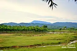 Skyline of Durgapur, Bangladesh | |
 Durgapur Location in Bangladesh | |
| Coordinates: 25°7.5′N 90°41.3′E | |
| Country | |
| Division | Mymensingh Division |
| District | Netrokona District |
| Area | |
| • Total | 293.42 km2 (113.29 sq mi) |
| Population (2011) | |
| • Total | 224,873 |
| • Density | 770/km2 (2,000/sq mi) |
| Time zone | UTC+6 (BST) |
| Website | Official Map of Durgapur |
Geography
Durgapur is located at 25.1250°N 90.6875°E. It has 32,245 households and a total land area of 293.42 km2.
Demographics
According to 2011 Bangladesh census, Durgapur had a population of 224,873. Males constituted 49.67% of the population and females 50.33%. Muslims formed 90.10% of the population, Hindus 5.87%, Christians 3.89%, and others 0.14%. Durgapur had a literacy rate of 39.52% for the population 7 years and above.[2]
At the 1991 Bangladesh census, Durgapur had a population of 169,135, of whom 83,795 were aged 18 or older. Males constituted 50.49% of the population, and females 49.51%. Durgapur had an average literacy rate of 23% (7+ years), compared to the national average of 32.4%.[3]
Composition of Durgapur Thana
Total Households: 8,250
1. Banai; Total Village: 1; Total Household: 6; Language Practiced: Banai; Religion Practiced: Hinduism;
2. Bangali; Total Village: 48; Total Household: 4,778; Language Practiced: Bengali;
3. Buna / Buno; Total Village: 3; Total Household: 37; Language Practiced: Bengali; Religion Practiced: Hinduism; Buna / Buno in Other Districts: Dhaka, Gazipur, Mymensingh, Rajbari, Sherpur, Tangail, Bagerhat, Jessore, Jhenaidah, Khulna, Kushtia, Magura, Satkhira, Bogra, Dinajpur, Joypurhat, Naogaon, Natore, Nilphamari, Pabna, Rajshahi, Sirajganj, Maulvibazar;
4. Garo; Number of Villages they lived with bangali: 10; Total Household: 924; Language Practiced: Achik / Garo (98.08%), Deal (1.92%); Religion Practiced: Christianity (99.96%), Shangsharik (0.04%); Garo lived in Other Districts: Sherpur, Mymensingh, Banderban, Chittagong,
5. Hajong; Number of Villages they lived with bangali: 08; Total Household: 505; Language Practiced: Hajong; Religion Practiced: Hinduism; Hajong in Other Districts: Mymensingh, Sherpur, Sunamganj;
The city's area is 293.42 sq km It is an ancient town situated on the banks of the river Somessori. This habitation known as a tourist area. There are civil and criminal courts here from British rule regime.
population Density 710 (per km2) literacy in rate in village 31.0% and in town 52.3% Population of the town 22661 and village 175665[4]
Administration
Durgapur Thana was formed in 1874 and converted into upazila was 1982.
Durgapur Upazila is divided into Durgapur Municipality and seven union parishads: Bakaljora, Birisiri, Chandigarh, Durgapur, Gaokandia, Kakairgara, and Kullagora. The union parishads are subdivided into 129 mauzas and 210 villages.[5]
Durgapur Municipality is subdivided into 9 wards and 30 mahallas.[5]
Notable residents
- Mustaque Ahmed Ruhi - Former Member of 9th National Parliament of 157th constituency which included this area.
Points of interest
- Tonk Movement Statue 1942-43
- TEBHAHA Movement
- Someshwari River
- Birishiri Trival cultural Academy
- Sagor Dighi
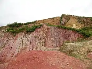
- Bijoypur
- Monosapara Adventist School & Seminary
- Ranikong Mission School
- Rashimoni Statue
- BGB Camp
- Blue Water Lake
Transport
Over last 10 years, Durgapur becomes a famous tourist spot. Bus or train are the main transport to go Durgapur. From Komplapur Railway Station, every night at 11.50 PM there is a train name Haor Express leave Dhaka to Netrokona.
Direct bus from Dhaka to Duragpur is available from Dhaka Mohakhali Inter City Bus Terminal, it usually takes 5 hours to reach Durgapur by bus.
Gallery
References
- Syed Marufuzzaman (2012), "Durgapur Upazila (Netrokona District)", in Sirajul Islam and Ahmed A. Jamal (ed.), Banglapedia: National Encyclopedia of Bangladesh (Second ed.), Asiatic Society of Bangladesh
- "Bangladesh Population and Housing Census 2011: Zila Report – Netrakona" (PDF). Table P01: Household and Population by Sex and Residence, Table P05: Population by Religion, Age group and Residence, Table P09 : Literacy of Population 7 Years & Above by Religion, Sex and Residence. Bangladesh Bureau of Statistics (BBS), Ministry of Planning, Government of the People’s Republic of Bangladesh. Retrieved 14 December 2018.
- "Population Census Wing, BBS". Archived from the original on 27 March 2005. Retrieved 10 November 2006.
- Details, eduguardian.com; accessed 3 September 2015.
- "District Statistics 2011: Netrokona" (PDF). Bangladesh Bureau of Statistics. Archived from the original (PDF) on 13 November 2014. Retrieved 14 July 2014.
| Upazilas | ||
|---|---|---|
| Constituencies | ||
| Attractions and sites | ||
| History | ||
| Inhabited areas | ||
| Rivers | ||
| Educational institutions | ||
| Transport | ||
Headquarters: Mymensingh | ||
| Jamalpur District | 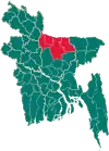 | |
| Mymensingh District | ||
| Netrokona District | ||
| Sherpur District | ||