Netrokona District
Netrokona (Bengali: নেত্রকোনা) is a district of the Mymensingh Division in northern Bangladesh.
Netrokona
নেত্রকোনা | |
|---|---|
| Netrokona District | |
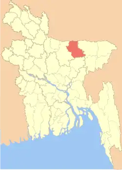 Location of Netrokona District in Bangladesh | |
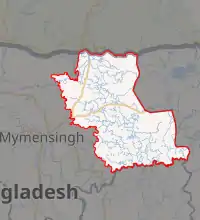
Expandable map of Netrokona District | |
| Coordinates: 24.88°N 90.73°E | |
| Country | |
| Division | Mymensingh Division |
| Government | |
| • Deputy Commissioner | Kazi Md. Abdur Rahman |
| Area | |
| • Total | 2,794.28 km2 (1,078.88 sq mi) |
| Population (2011 census) | |
| • Total | 2,229,642 |
| • Density | 800/km2 (2,100/sq mi) |
| Demonym(s) | Netrokoni, Netrokonese |
| Time zone | UTC+06:00 (BST) |
| Website | http://www.netrokona.gov.bd/ |
Etymology
The headquarters of Netrokona District was located at the bend of the Mogra River and was called Natorkona. Many people believe that over a period of time Natorkona became Netrakona.[1]
History
Shah Sultan Rumi migrated to Netrokona in 1053 CE where he preached the religion of Islam to the local people. He is believed to have been the earliest Sufi saint to have visited Bengal. During the Mughal period, a three domed mosque was constructed in modern-day Atpara. In 1880, the British Raj approved the area as a mahakuma administrative region.[2] It was effective on 3 January 1882 when the region was officially named as Netrakona Mahakuma before that it was named by Kaliganj. During British period, Shyam Biswas, a Bengali Hindu zamindar, was noted to be very cruel and abusive towards the inhabitants living in his land. He had certain regulations such as no one being allowed to pass his front yard wearing shoes or slippers. Social reformers from the village of Amati, Sonafor Uddin, Muktul Husayn Khan, Shariat Khan, Anfar Uddin, Manfar Uddin and Jafar Uddin organised people against this humiliation, rising against Biswas. Their revolution was soon followed in other parts of the district.
During the Bangladesh Liberation War, freedom fighters attacked the Atpara Thana on 19 August 1971. They murdered the Officer-in-Charge of the Thana as well as a number of Razakars; and they also looted arms and ammunition from the Thana. On 7 October, a battle was fought in Atpara leading to the death of three more Razakars.
The Government of Bangladesh converted Netrakona Mahakuma to Netrokona District on 17 January 1984.[1]
Geography
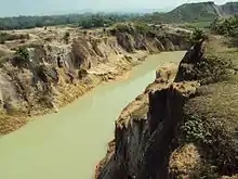
Netrokona is situated in the northern part of Bangladesh, near the Meghalayan border. There are five main rivers in Netrokona: Kangsha, Someshawri, Dhala, Magra, and Teorkhali. It is a part of the Surma-Meghna River System.[3]
The total area of Netrokona District is 2,794.28 km2 (1,078.88 sq mi) of which 9.17 km2 (3.54 sq mi) is under forest. It lies between 24°34’ and 25°12’ north latitudes and between 90°00’ and 91°07’ east longitudes.[1]
Netrokona District is bounded by the Garo Hills in Meghalaya, India on the north, Sunamganj District on the east, Kishoreganj District on the south and Mymensingh District on the west.[1]
Netrokona Pouroshabha is a municipal town, established in 1887 and with an area of 13.63 km2.
Upazilas
Netrokona district is divided into ten upazilas.[4]
Demographics
According to 2011 Bangladesh census, Netrokona District had a population of 2,229,642. Males constituted 49.84% of the population and females 50.16%. Muslims formed 89.78% of the population, Hindus 9.30%, Christians 0.82% and others 0.10%. Netrakona District had a literacy rate of 39.44% for the population 7 years and above.[5]
The major indigenous communities in this district are: Garo, Hajong, Hodi and Bana.[6]
Economy
The economy of Netrakona is largely agrarian. Susang Durgapur, an Upazila of Netrakona, is one of the major sources of country's China-Clay used for ceramic products. Its vast water bodies (Hawor) provides wide varieties of fishes. Bara Bazar and Choto Bazar is commerce centre of Netrakona.
Tourist attractions
- Durgapur : The Garo hills of Durgapur is the most popular tourist attraction of Netrakona.
- Birishiri : There is a Tribal Cultural Academy. And also have a historical big pond called Sagor Dighi.
- Haor : Haor is a large area of water spaces. Biggest hawor is located in Mohongonj and Khaliajuri . Dingaputa is one of the biggest hawor among them.
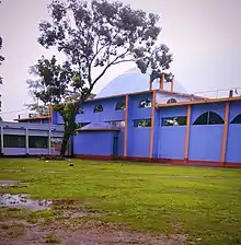
- Madanpur Mazar (Shah Sultan Rumi): It is situated 8 km south to the Netrokona Town.
- Ranikong Mission
Religion
The district of Netrakona consists 3146 mosques, 958 temples, 83 churches and eight Buddhist temples.1guruduara
Notable people
- Abu Taher, military serviceman
- Ahsan Habib- Writer, Cartoonist
- Akhlakul Hossain Ahmed – politician
- Bari Siddiqui - He was a Bangladeshi singer-songwriter, flutist and folk musician.
- Golam Samdani Koraishi, writer
- Helal Hafiz - Writer and poet.
- Humayun Ahmed - Author, dramatist and film director.
- Jalal Uddin TalukderFormer Member of Parliament.
- Kanha, a 10th-century poet
- Khalekdad Chowdhury, reputed Bangladeshi writer, playwright and novelist
- Mustafa Jabbar - President of Bangladesh Association of Software and Information Services (BASIS), President of Bangladesh Computer Samity
- Mustaque Ahmed Ruhi - Former Member of Parliament
- Nirmalendu Goon - Writer, poet, painter.
- Raushan Yazdani, author and folklorist
- Shahabuddin Ahmed, former President of Bangladesh
- Muhammad Zafar Iqbal, author, physicist, professor and activist. He is a professor of computer science and engineering at Shahjalal University of Science and Technology.
See also
- Districts of Bangladesh
- Dhaka Division
- History of Mymensingh
- Balish
References
| Wikimedia Commons has media related to Netrokona District. |
- "Bangladesh Population and Housing Census 2011: Zila Report – Netravkona" (PDF). Page xix: Physical features of Netrokona Zila. Bangladesh Bureau of Statistics (BBS), Ministry of Planning, Government of the People’s Republic of Bangladesh. Retrieved 14 December 2018.
- নেত্রকোনা জেলা. http. Retrieved 2019-07-19.
- Masud Hasan Chowdhury and Md Mahbub Murshed (2012). "Surma-Meghna River System". In Islam, Sirajul; Miah, Sajahan; Khanam, Mahfuza; Ahmed, Sabbir (eds.). Banglapedia: the National Encyclopedia of Bangladesh (Online ed.). Dhaka, Bangladesh: Banglapedia Trust, Asiatic Society of Bangladesh. ISBN 984-32-0576-6. OCLC 52727562. Retrieved 5 February 2021.
- Sarkar, Sanjay (2012). "Netrokona District". In Islam, Sirajul; Miah, Sajahan; Khanam, Mahfuza; Ahmed, Sabbir (eds.). Banglapedia: the National Encyclopedia of Bangladesh (Online ed.). Dhaka, Bangladesh: Banglapedia Trust, Asiatic Society of Bangladesh. ISBN 984-32-0576-6. OCLC 52727562. Retrieved 5 February 2021.
- "Bangladesh Population and Housing Census 2011: Zila Report – Netrakona" (PDF). Table P01 : Household and Population by Sex and Residence, Table P05 : Population by Religion, Age group and Residence, Table P09 : Literacy of Population 7 Years & Above by Religion, Sex and Residence. Bangladesh Bureau of Statistics (BBS), Ministry of Planning, Government of the People’s Republic of Bangladesh. Retrieved 14 December 2018.
- "Netrokona District". Banglapedia. Retrieved 14 December 2018.
External links
| Barisal Division |  | |
|---|---|---|
| Chittagong Division | ||
| Dhaka Division | ||
| Khulna Division | ||
| Mymensingh Division | ||
| Rajshahi Division | ||
| Rangpur Division | ||
| Sylhet Division | ||
Capital: Netrokona | ||
| Upazilas | ||
| Constituencies | ||
| Attractions and sites | ||
| Educational institutions | ||
| Inhabited areas | ||
| History | ||
| Transport | ||