Madan Upazila
Madan (Bengali: মদন) is an upazila of Netrokona District[1] in the Division of Mymensingh, Bangladesh.
Madan
মদন | |
|---|---|
 Madan Location in Bangladesh | |
| Coordinates: 24°43′N 90°58′E | |
| Country | |
| Division | Mymensingh Division |
| District | Netrokona District |
| Area | |
| • Total | 225.85 km2 (87.20 sq mi) |
| Population (2011) | |
| • Total | 154,479 |
| • Density | 680/km2 (1,800/sq mi) |
| Time zone | UTC+6 (BST) |
| Website | Official Map of Madan |
Geography
Madan is located at 24.7167°N 90.9667°E. It has 21,808 households and total area 225.85 km2.
Demographics
According to 2011 Bangladesh census, Madan had a population of 154,479. Males constituted 49.24% of the population and females 50.34%. Muslims formed 93.33% of the population, Hindus 6.59%, Christians 0.01% and others 0.08%. Madan had a literacy rate of 30.41% for the population 7 years and above.[2]
As of the 1991 Bangladesh census, Madan has a population of 117,613. Males constitute 50.99% of the population, and females 49.01%. This Upazila's eighteen up population is 58,127. Madan has an average literacy rate of 18.7% (7+ years), and the national average of 32.4% literate.[3]
Administration
Madan Upazila is divided into Madan Municipality and eight union parishads: Fatehpur, Gobindasree, Chandgaon, Kaitail, Madan, Maghan, Nayekpur, and Tiasree. The union parishads are subdivided into 84 mauzas and 114 villages.[4]
Madan Municipality is subdivided into 9 wards and 11 mahallas.[4]
Gallery
 Uchitpur Ghat at Madan.
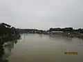 Mogra River from the bridge at Madan Upazila.
References
- Syed Marufuzzaman (2012), "Madan Upazila", in Sirajul Islam and Ahmed A. Jamal (ed.), Banglapedia: National Encyclopedia of Bangladesh (Second ed.), Asiatic Society of Bangladesh
- "Bangladesh Population and Housing Census 2011: Zila Report – Netrakona" (PDF). Table P01 : Household and Population by Sex and Residence, Table P05 : Population by Religion, Age group and Residence, Table P09 : Literacy of Population 7 Years & Above by Religion, Sex and Residence. Bangladesh Bureau of Statistics (BBS), Ministry of Planning, Government of the People’s Republic of Bangladesh. Retrieved 14 December 2018.
- "Population Census Wing, BBS". Archived from the original on 27 March 2005. Retrieved 10 November 2006.
- "District Statistics 2011: Netrokona" (PDF). Bangladesh Bureau of Statistics. Archived from the original (PDF) on 13 November 2014. Retrieved 14 July 2014.
| Upazilas | ||
|---|---|---|
| Constituencies | ||
| Attractions and sites | ||
| History | ||
| Inhabited areas | ||
| Rivers | ||
| Educational institutions | ||
| Transport | ||
Headquarters: Mymensingh | ||
| Jamalpur District | 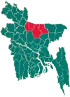 | |
| Mymensingh District | ||
| Netrokona District | ||
| Sherpur District | ||