Municipality of Burwood
The Municipality of Burwood is a local government area in the inner-west of Sydney, in the state of New South Wales, Australia.
| Municipality of Burwood New South Wales | |||||||||||||||
|---|---|---|---|---|---|---|---|---|---|---|---|---|---|---|---|
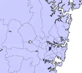 Location in Greater Sydney | |||||||||||||||
| Coordinates | 33°53′S 151°06′E | ||||||||||||||
| Population |
| ||||||||||||||
| • Density | 5,300/km2 (13,600/sq mi) | ||||||||||||||
| Established | 27 March 1874[3] | ||||||||||||||
| Area | 7 km2 (2.7 sq mi) | ||||||||||||||
| Mayor | John Faker (Labor) | ||||||||||||||
| Council seat | Burwood | ||||||||||||||
| Region | Metropolitan Sydney | ||||||||||||||
| State electorate(s) | Strathfield | ||||||||||||||
| Federal Division(s) | |||||||||||||||
| Website | Municipality of Burwood | ||||||||||||||
| |||||||||||||||
The Mayor of the Municipality is Cr. John Faker, a member of the Labor Party, who was first elected on 8 September 2012.
Suburbs in the local government area
The following suburbs within the Municipality of Burwood are:
The Municipality also includes portions of:
- Croydon (shared with Inner West Council)
- Croydon Park (shared with the City of Canterbury-Bankstown and Inner West Council)
- Strathfield (shared with the City of Canada Bay and Municipality of Strathfield)
Demographics
At the 2016 census, there were 36,809 people in the Burwood local government area, of these 48.3 per cent were male and 51.7 per cent were female. Aboriginal and Torres Strait Islander people made up 0.4 per cent of the population; significantly below the NSW and Australian averages of 2.9 and 2.8 per cent respectively. The median age of people in the Municipality of Burwood was 33 years. Children aged 0 – 14 years made up 13.0 per cent of the population and people aged 65 years and over made up 14.3 per cent of the population. Of people in the area aged 15 years and over, 42.2 per cent were married and 6.0 per cent were either divorced or separated.[1]
Population growth in the Municipality of Burwood between the 2001 census and the 2006 census was 5.26 per cent; and in the subsequent five years to the 2011 census, population growth was 4.84 per cent. At the 2016 census, the population in the Municipality increased by 13.53 per cent. When compared with total population growth of Australia for the same period, being 8.8 per cent, population growth in Burwood local government area was significantly higher than the national average.[4][5] The median weekly income for residents within the Municipality of Burwood of was generally on par with the national average.[1]
At the 2016 census, the proportion of residents in Burwood local government area who stated their ancestry as Chinese was in excess of seven times the state and national averages; and the proportion of households where an Asian language was spoken at home was approximately eight times higher than the national average.[1]
| Selected historical census data for Burwood local government area | ||||||
|---|---|---|---|---|---|---|
| Census year | 2001[4] | 2006[5] | 2011[6] | 2016[1] | ||
| Population | Estimated residents on census night | 29,381 | ||||
| LGA rank in terms of size within New South Wales | 57th | |||||
| % of New South Wales population | 0.46% | |||||
| % of Australian population | 0.16% | |||||
| Cultural and language diversity | ||||||
| Ancestry, top responses | Chinese | 21.8% | ||||
| English | 9.9% | |||||
| Australian | 10.4% | |||||
| Italian | 8.0% | |||||
| Irish | 4.6% | |||||
| Language, top responses (other than English) | Mandarin | 5.8% | ||||
| Cantonese | 7.8% | |||||
| Italian | 7.3% | |||||
| Korean | 5.4% | |||||
| Arabic | 5.7% | |||||
| Religious affiliation | ||||||
| Religious affiliation, top responses | No religion, so described | 12.6% | ||||
| Catholic | 36.9% | |||||
| Not stated | 8.2% | |||||
| Hinduism | n/c | n/c | ||||
| Buddhism | 5.8% | |||||
| Median weekly incomes | ||||||
| Personal income | Median weekly personal income | A$403 | A$490 | Data to be released in October 2017 | ||
| % of Australian median income | 86.5% | |||||
| Family income | Median weekly family income | A$1,071 | A$1,441 | |||
| % of Australian median income | 104.3% | |||||
| Household income | Median weekly household income | A$1,194 | A$1,310 | |||
| % of Australian median income | 102.0% | |||||
Council
Current composition and election method
Burwood Council is composed of seven Councillors, including the Mayor, for a fixed four-year term of office. The Mayor is directly elected while the six other Councillors are elected proportionally as one ward. The most recent election was held on 9 September 2017, and the makeup of the Council, including the Mayor, was as follows:[7][8]
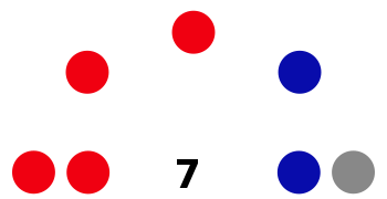
| Party | Councillors | |
|---|---|---|
| Australian Labor Party | 4 | |
| Liberal Party of Australia | 2 | |
| Independent Community Voice | 1 | |
| Total | 7 | |
The current Council, elected in 2017, in order of election, is:[7]
| Councillor | Party | Notes | |
|---|---|---|---|
| John Faker | Labor | Mayor: 2012–date[8] | |
| Heather Crichton | Labor | ||
| Joseph Del Duca | Liberal | ||
| Lesley Furneaux-Cook | Independent Community Voice | Mayor: 2008–2009[9] Deputy Mayor: 2017–date[10] | |
| George Mannah | Labor | Deputy Mayor: 2016–2017 | |
| Ernest Chan | Labor | ||
| Raj Dixit | Liberal | ||
History
The municipality was incorporated on 27 March 1874. The council chambers in Conder Street were designed by architect Jack Hennessy and built in 1877. Hennessy was later mayor of Burwood.[11]
A 2015 review of local government boundaries by the NSW Government Independent Pricing and Regulatory Tribunal recommended that the Municipality of Burwood merge with adjoining councils. The government proposed a merger of the Burwood, Canada Bay, and Strathfield Councils to form a new council with an area of 41 square kilometres (16 sq mi) and support a population of approximately 163,000.[12] In May 2016 Strathfield Council challenged the proposed merger between Strathfield, Burwood and Canada Bay and commenced proceedings in the New South Wales Land and Environment Court. After the Court heard that there were legal flaws in the report from the State Government appointed delegate who examined the proposal for merging the councils, the NSW Government withdrew from the case and the merger proposal stalled.[13] In July 2017, the Berejiklian government decided to abandon the forced merger of the Strathfield, Burwood and Canada Bay local government areas, along with several other proposed forced mergers.[14]
Heritage listings
The Municipality of Burwood has a number of heritage-listed sites, including the following sites listed on the New South Wales State Heritage Register:
- Burwood, 168a Burwood Road: Burwood Post Office[15]
- Burwood, 205 Burwood Road: St Paul's Anglican Church, Burwood[16]
- Burwood, 213 Burwood Road: The Priory, Burwood[17]
- Burwood, 223 Burwood Road: St. Cloud, Burwood[18]
- Burwood, 4 Clarence Street: Lynton, Burwood[19]
- Burwood, Great Southern and Western railway: Burwood rail underbridge[20]
- Burwood, Great Southern and Western railway: Burwood railway station, Sydney[21]
- Burwood, Railway Parade: Burwood Sewer Vent[22]
- Croydon, Boundary Street: Shubra Hall[23]
- Croydon, Paisley Road: Croydon Sewer Vent[24]
- Strathfield, 62 The Boulevarde: Trinity Uniting Church, Strathfield[25]
Council Logo
Burwood Council introduce in September 2019 a new bold logo designed to reflect the changes which have made it a vibrant and multicultural destination while retaining its heritage. The new logo design, based on the letter `B’, is divided into six parts for the suburbs of the area: Burwood, Burwood Heights, Croydon, Croydon Park, Enfield and Strathfield. Residents’ priorities are represented by the colour scheme: harmony and friendship (pink), trust and stability (light blue), creativity and vibrancy (orange), heritage and heart (red), the natural environment (green) and energy and optimism (yellow). Traditional typeface has been used in keeping with the commitment to heritage.[26]
The previous ‘Municipality of Burwood’ logo was designed in 1936.[27]
See also
References
- Australian Bureau of Statistics (27 June 2017). "Burwood (A)". 2016 Census QuickStats. Retrieved 5 July 2017.

- "3218.0 – Regional Population Growth, Australia, 2017-18". Australian Bureau of Statistics. 27 March 2019. Retrieved 27 March 2019. Estimated resident population (ERP) at 30 June 2018.
- "Government Gazette Proclamations and Legislation - New South Wales Government Gazette (Sydney, NSW : 1832 - 1900) - 27 Mar 1874". nla.gov.au. Retrieved 3 March 2017.
- Australian Bureau of Statistics (9 March 2006). "Burwood (A)". 2001 Census QuickStats. Retrieved 1 November 2012.
- Australian Bureau of Statistics (25 October 2007). "Burwood (A)". 2006 Census QuickStats. Retrieved 1 November 2012.
- Australian Bureau of Statistics (31 October 2012). "Burwood (A)". 2011 Census QuickStats. Retrieved 1 November 2012.
- "Burwood - Councillor Contest". NSW Local Council Elections 2017. NSW Electoral Commission. Retrieved 27 September 2017.
- "Burwood - Mayoral Contest". NSW Local Council Elections 2017. NSW Electoral Commission. Retrieved 27 September 2017.
- Habib, Rashell (2 March 2009). "Praise for women of wonder". NewsLocal.
- "Mayor and Councillors | Burwood Council". www.burwood.nsw.gov.au. Retrieved 20 October 2017.
- "Burwood Council Chambers, 2-4 Conder St, Burwood, NSW, Australia". Australian Heritage Database. Australian Government. Retrieved 1 December 2014.
- "Merger proposal: Burwood Council, City of Canada Bay Council, Strathfield Council" (PDF). Government of New South Wales. January 2016. p. 7. Retrieved 27 February 2016.
- Raper, Ashleigh (31 May 2016). "NSW council amalgamations: Strathfield, Burwood and Canada Bay merger stopped". ABC News. Australia. Retrieved 1 June 2016.
- Blumer, Clare; Chettle, Nicole (27 July 2017). "NSW council amalgamations: Mayors fight to claw back court dollars after backflip on merger". ABC News. Australia. Retrieved 27 July 2017.
- "Burwood Post Office (former)". New South Wales State Heritage Register. Office of Environment and Heritage. H01490. Retrieved 18 May 2018.
- "St. Paul's Anglican Church and Pipe Organ". New South Wales State Heritage Register. Office of Environment and Heritage. H00436. Retrieved 18 May 2018.
- "Priory and Grounds". New South Wales State Heritage Register. Office of Environment and Heritage. H00287. Retrieved 18 May 2018.
- "St. Cloud and Site". New South Wales State Heritage Register. Office of Environment and Heritage. H00564. Retrieved 18 May 2018.
- "Lynton". New South Wales State Heritage Register. Office of Environment and Heritage. H00284. Retrieved 18 May 2018.
- "Burwood rail underbridge". New South Wales State Heritage Register. Office of Environment and Heritage. H01030. Retrieved 18 May 2018.
- "Burwood Railway Station group". New South Wales State Heritage Register. Office of Environment and Heritage. H01106. Retrieved 18 May 2018.
- "Burwood Sewer Vent". New South Wales State Heritage Register. Office of Environment and Heritage. H01638. Retrieved 18 May 2018.
- "Shubra Hall, including stables and garden". New South Wales State Heritage Register. Office of Environment and Heritage. H01939. Retrieved 18 May 2018.
- "Croydon Sewer Vent". New South Wales State Heritage Register. Office of Environment and Heritage. H01639. Retrieved 18 May 2018.
- "Trinity Uniting Church". New South Wales State Heritage Register. Office of Environment and Heritage. H01671. Retrieved 18 May 2018.
- https://www.burwood.nsw.gov.au/news_and_highlights__homepage/2019/exciting_new_look_for_burwood.html
- https://www.burwood.nsw.gov.au/verve/_resources/MEDIA_RELEASE_-_Contemporary_colourful_-_Burwood%E2%80%99s_new_look.pdf