Hornsby Shire
Hornsby Shire is a local government area situated in Northern Sydney (Upper North Shore), as well as parts of the Hills District, in the state of New South Wales, Australia. The shire stretches from the M2 Hills Motorway in the south to the Hawkesbury River town of Wisemans Ferry, some 53 kilometres (33 mi) to the north, making it the largest local government council in the Greater Sydney Metropolitan region by total area. As of the 2016 census the shire had an estimated population of 142,667.[1]
| Hornsby Shire New South Wales | |||||||||||||||
|---|---|---|---|---|---|---|---|---|---|---|---|---|---|---|---|
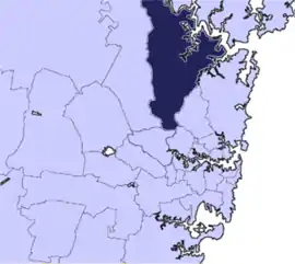 Location in Metropolitan Sydney | |||||||||||||||
| Coordinates | 33.7°S 151.1°E | ||||||||||||||
| Population |
| ||||||||||||||
| • Density | 313.6/km2 (812.1/sq mi) | ||||||||||||||
| Established | 6 March 1906 | ||||||||||||||
| Area | 455 km2 (175.7 sq mi) | ||||||||||||||
| Mayor | Philip Ruddock (Liberal) | ||||||||||||||
| Council seat | Hornsby | ||||||||||||||
| Region | Metropolitan Sydney | ||||||||||||||
| State electorate(s) | |||||||||||||||
| Federal Division(s) | |||||||||||||||
| Website | Hornsby Shire | ||||||||||||||
| |||||||||||||||
The Mayor of Hornsby Shire is Cr Philip Ruddock, a member of the Liberal Party, who was elected on 9 September 2017.
Suburbs, towns and localities in the local government area
Suburbs in the Hornsby Shire include:
- Asquith
- Beecroft (shared with City of Parramatta Council)
- Berowra
- Berowra Heights
- Berowra Waters
- Brooklyn
- Castle Hill (shared with The Hills Shire)
- Cheltenham
- Cherrybrook
- Cowan
- Hornsby
- Hornsby Heights
- Mount Colah
- Mount Kuring-gai
- Normanhurst
- North Epping
- Pennant Hills
- Thornleigh
- Wahroonga (shared with Ku-ring-gai Council)
- Waitara
- Westleigh
- West Pennant Hills (shared with The Hills Shire)
Towns and localities in the Hornsby Shire are:
- Arcadia
- Berrilee
- Bobbin Head
- Canoelands
- Dangar Island
- Dural (shared with The Hills Shire)
- Fiddletown
- Fishermans Point
- Forest Glen
- Galston
- Glenhaven (shared with The Hills Shire)
- Glenorie (shared with The Hills Shire)
- Hookhams Corner
- Laughtondale
- Maroota (shared with The Hills Shire)
- Middle Dural (shared with The Hills Shire)
- Milsons Passage
- Roselea
- Round Corner
- Singletons Mill
- Thompsons Corner
- Wisemans Ferry (shared with Central Coast Council, City of Hawkesbury and The Hills Shire)
- Rogans Hill
Demographics
At the 2016 census, there were 142,667 people in the Hornsby local government area, of these 48.8 per cent were male and 51.2 per cent were female. Aboriginal and Torres Strait Islander people made up 0.5 per cent of the population; significantly below the NSW and Australian averages of 2.9 and 2.8 per cent respectively. The median age of people in the Hornsby Shire was 40 years; slightly higher than the national median of 38 years. Children aged 0 – 14 years made up 19.5 per cent of the population and people aged 65 years and over made up 16.2 per cent of the population. Of people in the area aged 15 years and over, 58.8 per cent were married and 8.2 per cent were either divorced or separated.[1]
Population growth in the Hornsby Shire between the 2001 census and the 2006 census was 4.58 per cent and in the subsequent five years to the 2011 census, population growth was 3.65 per cent. At the 2016 census, the population in the Shire decreased by 9.04 per cent brought about predominately by an adjustment in local government boundaries.[1][3][4] The median weekly income for residents within the Hornsby Shire was higher than the national average.
| Selected historical census data for Hornsby local government area | ||||||
|---|---|---|---|---|---|---|
| Census year | 2001[5] | 2006[3] | 2011[4] | 2016[1] | ||
| Population | Estimated residents on census night | 144,692 | 151,325 | 156,847 | 142,667 | |
| LGA rank in terms of size within New South Wales | 16th | |||||
| % of New South Wales population | 2.27% | |||||
| % of Australian population | 0.77% | |||||
| Cultural and language diversity | ||||||
| Ancestry, top responses | English | 23.5% | ||||
| Australian | 22.4% | |||||
| Chinese | 9.8% | |||||
| Irish | 7.1% | |||||
| Scottish | 6.3% | |||||
| Language, top responses (other than English) | Mandarin | 2.0% | ||||
| Cantonese | 4.6% | |||||
| Korean | 1.6% | |||||
| Hindi | 0.7% | |||||
| Persian including Dari | n/c | n/c | n/c | |||
| Religious affiliation | ||||||
| Religious affiliation, top responses | No religion, so described | 14.0% | ||||
| Catholic | 24.6% | |||||
| Anglican | 23.4% | |||||
| Not stated | n/c | n/c | n/c | |||
| Hinduism | 1.8% | |||||
| Median weekly incomes | ||||||
| Personal income | Median weekly personal income | A$580 | A$682 | A$793 | ||
| % of Australian median income | 124.5% | 118.2% | 119.8% | |||
| Family income | Median weekly family income | A$1,514 | A$2,119 | A$2,372 | ||
| % of Australian median income | 147.4% | 143.1% | 136.8% | |||
| Household income | Median weekly household income | A$1,763 | A$1,824 | A$2,121 | ||
| % of Australian median income | 150.5% | 147.8% | 147.5% | |||
Council
Current composition and election method
Hornsby Shire Council is composed of ten Councillors, including the Mayor, for a fixed four-year term of office. The Mayor is directly elected while the nine other Councillors are elected proportionally as three separate wards, each electing three Councillors. The most recent election was held on 9 September 2017, and the makeup of the council, including the Mayor, is as follows:[6]
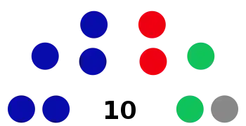
| Party | Councillors | |
|---|---|---|
| Liberal Party of Australia | 5 | |
| The Greens | 2 | |
| Australian Labor Party | 2 | |
| Independents | 1 | |
| Total | 10 | |
The current Council, elected in 2017, in order of election by ward, is:
| Ward | Councillor | Party | Notes | |
|---|---|---|---|---|
| Mayor[7] | Philip Ruddock | Liberal | ||
| A Ward[8] | Nathan Tilbury | Liberal | Deputy Mayor 2013–2014 | |
| Warren Waddell | Liberal | |||
| Mick Marr | Labor | |||
| B Ward[9] | Robert Browne | Liberal | ||
| Joseph Nicita | Greens | |||
| Janelle McIntosh | Labor | |||
| C Ward[10] | Michael Hutchence | Liberal | Deputy Mayor 2010–2011, 2015–date | |
| Emma Heyde | Greens | |||
| Vince Del Gallego | Independent | |||
Past mayors and shire presidents
History
Hornsby Shire is the traditional lands occupied by the Darug and Kuringgai peoples of indigenous Australians. While the northern part of the Shire via the Hawkesbury River was visited by the first European settlers in late 1788, due to the Shire's rugged landscape permanent European settlement did not begin until almost half a century later.
Hornsby Shire got its name from the town of Hornsby at the eastern end of the Shire, is derived from convict-turned-Constable Samuel Horne, who earned distinction by capturing bushrangers Dalton and MacNamara on 22 June 1830. In return he was granted land in the locality known as "Hornsby Place".
Hornsby Shire has remained largely rural for many decades. The construction of the Main North railway line in the 1880s opened up the Shire to the rest of Sydney and also to Newcastle, but it was not until motor vehicles became commonplace in the 1950s that the southern part of the Shire truly became part of Sydney's suburbia. The Shire was incorporated as a local government authority on 6 March 1906.
A 2015 review of local government boundaries by the NSW Government Independent Pricing and Regulatory Tribunal recommended that Hornsby Shire merge with adjoining councils. The government considered two proposals. The first proposed a merger of part of Hornsby with the Ku-ring-gai Council to form a new council with an area of 540 square kilometres (210 sq mi) and support a population of approximately 270,000.[11] The second proposed a merger of parts of Parramatta, Auburn, The Hills, Hornsby, and Holroyd to form a new council with an area of 82 square kilometres (32 sq mi) and support a population of approximately 215,725.[12] The outcome of the review was that the suburbs of Hornsby Shire Council south of the M2 joined an expanded Parramatta City Council. The NSW Government also gave in principle support for the Hornsby Shire suburbs north of the M2 to amalgamate with Ku-ring-gai Council. In July 2017, the Berejiklian government decided to abandon the forced merger of the Hornsby and Ku-ring-gai local government areas, along with several other proposed forced mergers.[13] This failed merger resulted in the council losing lucrative area south of the M2 including Epping and Carlingford.[14]
Heritage listings
The Hornsby Shire has a number of heritage-listed sites, including:
- Brooklyn, Main Northern railway: Hawkesbury River railway station[15]
- Cheltenham, 67 Cobran Road: Ahimsa, Cheltenham[16]
- Galston, 161 Main Road: Tunks Creek Bridge[17]
- Galston, 11 School Road: Galston Congregational Church Pipe Organ[18]
- Hornsby, 2a Manor Road (Rosamond Street): Mount Wilga House[19]
- Hornsby, Old Man's Valley, off Quarry Road: Old Man's Valley Cemetery[20]
- Normanhurst, 82-84 Pennant Hills Road: Gilligaloola[21]
- Wahroonga, 9 Highlands Avenue: Highlands[22]
Geography
Hornsby calls itself the 'Bushland Shire'. This is in reference to its location on a high ridge separating two expansive areas of natural bushland which consists of up to 70% of the total area:[23] The Ku-ring-gai Chase National Park on the eastern side and the Berowra Valley Regional Park on the western side. These provide large areas of natural parkland that form a green belt running from Sydney at the south to the Hawkesbury River at the Shire's northern end. These parks are extremely popular with day-trippers from all areas of Sydney and provides diverse recreations such as bushwalking and boating.
The northern half of Hornsby Shire remains a semi-rural area, retaining a number of farmlands and market gardens. This area consists of small village settlements such as Mount Colah and Hornsby Heights. The village of Galston is the centre of this rural area.
The western part of the shire shares a 53-kilometre (33 mi) border with The Hills Shire and is separated from the rest of the Shire by national parks and the Galston Gorge.
The southern half of the Shire is urban, forming part of Sydney's suburbia on the North Shore and Northern Suburbs. Traditionally most of the Shire's residents live in free-standing houses, but in recent years a number of semi-detached housings as well as high-density apartments have appeared around Hornsby's central business district.
The Shire has several areas with industrial activity including Hornsby, Asquith and Thornleigh. The major commercial centres of the Shire, apart from Hornsby's central business district, are the suburbs of Pennant Hills and North Epping.
Local attractions in the Hornsby Shire include its easily accessible wilderness areas including part of the Great North Walk, parkland recreational facilities such as Fagan Park at Galston, Pennant Hills Park, Koala Park Sanctuary in West Pennant Hills, and the village of Brooklyn on the Hawkesbury River.
Hornsby Shire has four public libraries (at Hornsby, Pennant Hills, Berowra and Galston, two public swimming pools ("Aquatic Centres"), and a range of other sporting and community facilities.
References
- Australian Bureau of Statistics (27 June 2017). "Hornsby (C)". 2016 Census QuickStats. Retrieved 5 July 2017.

- "3218.0 – Regional Population Growth, Australia, 2017-18". Australian Bureau of Statistics. 27 March 2019. Retrieved 27 March 2019. Estimated resident population (ERP) at 30 June 2018.
- Australian Bureau of Statistics (25 October 2007). "Hornsby (A)". 2006 Census QuickStats. Retrieved 6 December 2012.
- Australian Bureau of Statistics (31 October 2012). "Hornsby (C)". 2011 Census QuickStats. Retrieved 23 November 2012.
- Australian Bureau of Statistics (9 March 2006). "Hornsby (A)". 2001 Census QuickStats. Retrieved 6 December 2012.
- Green, Anthony. "Council of the Shire of Hornsby". ABC News. Australian Broadcasting Corporation. Retrieved 26 September 2017.
- "Hornsby - Mayoral Contest". NSW Local Council Elections 2017. NSW Electoral Commission. Retrieved 10 October 2017.
- "Hornsby - Ward A". NSW Local Council Elections 2017. NSW Electoral Commission. Retrieved 10 October 2017.
- "Hornsby - Ward B". NSW Local Council Elections 2017. NSW Electoral Commission. Retrieved 10 October 2017.
- "Hornsby - Ward C". NSW Local Council Elections 2017. NSW Electoral Commission. Retrieved 10 October 2017.
- "Merger proposal: Hornsby Shire Council (part), Ku-ring-gai Council" (PDF). Government of New South Wales. January 2016. p. 7. Retrieved 22 February 2016.
- "Merger proposal: Parramatta City Council (part), Auburn City Council (part), The Hills Shire Council (part), Hornsby Shire Council (part), Holroyd City Council (part)" (PDF). Government of New South Wales. January 2016. p. 8. Retrieved 22 February 2016.
- Blumer, Clare; Chettle, Nicole (27 July 2017). "NSW council amalgamations: Mayors fight to claw back court dollars after backflip on merger". ABC News. Australia. Retrieved 27 July 2017.
- http://www.smh.com.au/nsw/frustrated-hornsby-council-demands-the-return-of-land-lost-to-amalgamation-20170712-gx9vqt.html
- "Hawkesbury River Railway Station group". New South Wales State Heritage Register. Office of Environment and Heritage. H01166. Retrieved 18 May 2018.
- "Ahimsa". New South Wales State Heritage Register. Office of Environment and Heritage. H01494. Retrieved 18 May 2018.
- "Bridge over Tunks (Pearces) Creek". New South Wales State Heritage Register. Office of Environment and Heritage. H01478. Retrieved 18 May 2018.
- "Pipe Organ from Bourke Street Congregational Church (former)". New South Wales State Heritage Register. Office of Environment and Heritage. H00382. Retrieved 18 May 2018.
- "Mount Wilga House". New South Wales State Heritage Register. Office of Environment and Heritage. H00535. Retrieved 18 May 2018.
- "Old Man's Valley Cemetery". New South Wales State Heritage Register. Office of Environment and Heritage. H01764. Retrieved 18 May 2018.
- "Gilligaloola". New South Wales State Heritage Register. Office of Environment and Heritage. H00271. Retrieved 18 May 2018.
- "Highlands". New South Wales State Heritage Register. Office of Environment and Heritage. H00034. Retrieved 18 May 2018.
- http://www.hornsby.nsw.gov.au/__data/assets/pdf_file/0011/98129/ulowresFNL-Whole-Updated-Snapshot-of-the-Hornsby-Shire-in-2016.pdf
External links
- Joan Rowland (2011). "Hornsby Shire". Dictionary of Sydney. Retrieved 27 September 2015. [CC-By-SA]
Hawkesbury River region, New South Wales, Australia | |||||||||
|---|---|---|---|---|---|---|---|---|---|
| Islands | |||||||||
| National parks and nature reserves | |||||||||
| European explorers of the region | |||||||||
| Bridges and ferries |
| ||||||||
| Adjoining rivers, bays, reservoirs, and creeks |
| ||||||||
| Local government areas | |||||||||
| Education |
| ||||||||
| Major attractions | |||||||||
| |||||||||