Egypt, Pennsylvania
Egypt is an unincorporated community and census-designated place (CDP) in Whitehall Township, Lehigh County, Pennsylvania, United States, about 7 miles (11 km) north of Allentown.
Egypt, Pennsylvania | |
|---|---|
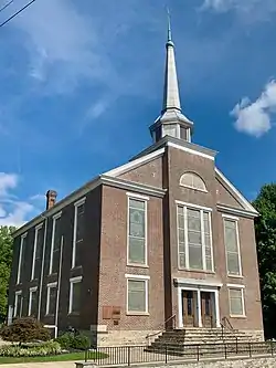 Egypt Community Church, built 1851 | |
 Location in Lehigh County | |
 Egypt Location in Pennsylvania  Egypt Location in the United States | |
| Coordinates: 40°40′48″N 75°31′48″W | |
| Country | United States |
| State | Pennsylvania |
| County | Lehigh |
| Township | Whitehall |
| Area | |
| • Total | 1.45 sq mi (3.76 km2) |
| • Land | 1.45 sq mi (3.75 km2) |
| • Water | 0.004 sq mi (0.01 km2) |
| Elevation | 413 ft (126 m) |
| Population (2010)[2] | |
| • Total | 2,391 |
| • Density | 1,653/sq mi (638.4/km2) |
| Time zone | UTC-5 (EST) |
| • Summer (DST) | UTC-4 (EDT) |
| ZIP Code | 18052 |
| Area code(s) | 610 |
| FIPS code | 42-22696 |
| GNIS feature ID | 1174043 |
The population of Egypt was 2,391 as of the 2010 census.[2]
Geography
Egypt is located in northeastern Lehigh County, in the northwest corner of Whitehall Township. It is bordered to the east by Cementon and to the north and west by North Whitehall Township. Pennsylvania Route 329 is Egypt's Main Street and runs 1.5 miles (2.4 km) east into Cementon and 5 miles (8 km) west to Neffs. PA-329 intersects PA-145 on the eastern edge of Egypt, at the area known as Eagle Point. PA-145 leads north 8 miles (13 km) to Walnutport and south 6.5 miles (10.5 km) to the center of Allentown.
According to the U.S. Census Bureau, the Egypt CDP has a total area of 1.5 square miles (3.8 km2), of which 2.4 acres (9,595 m2), or 0.26%, are water.[1] Coplay Creek, a tributary of the Lehigh River, flows east through the southern part of the community. Via the Lehigh, the community is part of the Delaware River watershed.
History

Egypt is one of the oldest communities in eastern Pennsylvania, having been settled as early as 1733.[3] It was the first settlement in Pennsylvania north of South Mountain.[4]
Early Pennsylvania German settlers of nearby present-day Lynn and Albany townships had named the area where they settled Alle mängel ("all deficiencies") due to the poor quality of the soil on which they were trying to farm and raise crops. By contrast, the soil here was found to be quite fertile, and early settlers named this region "Egypta", since ancient Egypt, with its fertile Nile delta, was the "granary of the world".[5]
The Reformed Congregation of Egypt Church was established in 1734, and a log church was erected in 1764.[6] The cemetery of the Egypt church contains the graves of many of the region's earliest inhabitants, including 25 veterans of the American Revolutionary War, 15 veterans of the War of 1812, and nine veterans of the American Civil War.[7] Across the street from the church stands Egypt's World War I monument, which honors the 76 men from Egypt who served during that war. Dedicated on June 10, 1923, the centerpiece of the monument is the pressed copper sculpture, Spirit of the American Doughboy, by E. M. Viquesney.
One of the first settlers, John Jacob Mickley (1697–1769), started farming here in 1745.[8]
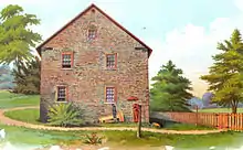
In 1755, Jacob Kohler established a gristmill, located along Coplay Creek just south of the church.[3] The Troxell-Steckel House, which was built in Egypt in 1756, is one of the oldest buildings in Lehigh County[9] and is today operated as a museum and historic site by the Lehigh County Historical Society. The Egypt area was also the location of Fort Deshler, a French and Indian War era frontier fort established in 1760 to protect settlers from Indian attacks.[10] The fort, which was near the present intersection of PA Route 145 and Chestnut Street, stood until about 1940. The site is commemorated by a Pennsylvania Historical and Museum Commission marker.[11] A granite marker, located just outside Egypt at Scheidy's Road and Spring Street in North Whitehall Township, commemorates the last Indian attack in Lehigh County, which occurred on October 8, 1763, when nine settlers were murdered.[12][13]
The earliest hotel in the area was the Werley House, which operated from 1796 to 1815.[14] The first "English school" (as opposed to one that taught students in the Pennsylvania German dialect) was organized in 1808.[14] Other early industries in the immediate area included a carriage works, coal yard, bakery, tannery and silk works.
Development of the community was spurred by the organization of the American Improved Cements Company (later American Cement Company), which took over and modernized the older Egypt Mills cement plant, located on the north side of Chestnut Street. In 1884, the company shipped its first load of cement to market using the Ironton Railroad. In 1896, American Cement ran power lines to supply the village of Egypt with electricity from its own power plants.[15] American Cement, which subsequently opened a number of mills in the Egypt area, operated until 1913, when it was purchased by Giant Portland Cement.[16] In addition to the Egypt Mills plant, Giant Portland operated six other cement mills in Egypt (Pennsylvania, Columbia, Giant #1 & #2, Central and Reliance), and had an annual production capacity of 2.1 million barrels of cement.[16] Parts of the New York City Subway were built using cement manufactured in Egypt's mills.[16] Giant Portland ceased production around 1929, and mills were either closed or sold to other companies operating in the area. Today, cement production remains an important part of the local economy, and plants in the area are operated by Nazareth-based ESSROC, a subsidiary of the Italian firm Italcementi, and the French company Lafarge.
On June 2, 1947, the Philadelphia Phillies came to the Egypt Park to play an Egypt area high school team of the old Twilight League. The Phillies came to entice Curt Simmons, a 17-year-old Whitehall High School pitcher from Main Street in Egypt, to play for them. Simmons took the Phillies to the wire, and the Phillies came back and tied the Egypt team 4-4 on account of darkness.
| Historical population | |||
|---|---|---|---|
| Census | Pop. | %± | |
| 2000 | 2,291 | — | |
| 2010 | 2,391 | 4.4% | |
Notable residents
- Althea Henley, former actress
- Dan Koppen, professional football player, New England Patriots
- Curt Simmons, former professional baseball player, California Angels, Chicago Cubs, Philadelphia Phillies and St. Louis Cardinals
Public education
Egypt is part of the Whitehall-Coplay School District. Students in grades nine through 12 attend Whitehall High School.
References
- "2019 U.S. Gazetteer Files: Places: Pennsylvania". United States Census Bureau. Retrieved October 26, 2020.
- "Total Population: 2010 Census DEC Summary File 1 (P1), Egypt CDP, Pennsylvania". data.census.gov. U.S. Census Bureau. Retrieved October 26, 2020.
- Roberts, Charles Rhoads; Stoudt, Rev. John Baer; Krick, Rev. Thomas H.; Dietrich, William J. (1914). History of Lehigh County Pennsylvania and a Genealogical and Biographical Records of its Families. 1. Lehigh Valley Publishing Company. p. 1012.
- Gensey, Karen L. (2004). Whitehall, Pennsylvania: The Golden Strip of the Lehigh Valley. Kutztown Publishing Company. OCLC 262464697. Page 19
- Henry, Michael S. (1860). History of the Lehigh Valley. Easton, Pennsylvania: Bixler & Company.Page 304
- Roberts, Charles Rhoads (1908). History of the Reformed Congregation of Egypt Church. Allentown, Pennsylvania: Lehigh County Historical Society. hdl:2027/loc.ark:/13960/t2t43zs9j. Retrieved 2020-09-26 – via Library of Congress.
- Gensey, Page 139.
- Mathews, Alfred; Hungerford, Austin N. (1884). "Whitehall Township, Settlement". History of the Counties of Lehigh and Carbon, in the Commonwealth of Pennsylvania. Philadelphia: Everts & Richards. pp. 482–483. OL 227379W.
- Roberts, History of Lehigh County, Page 1016.
- Roberts, History of Lehigh County, Page 111.
- "Pennsylvania Historical Marker Search" (Searchable database). Pennsylvania Historical and Museum Commission. Commonwealth of Pennsylvania. Retrieved 2020-09-26.
- Roberts, History of Lehigh County, Pages 104-107.
- Roberts et al. (1914), p. 845.
- Roberts, History of Lehigh County, Page 1015.
- Gensey, Page 105.
- Gensey, Page 106.
Further reading
- Gensey, Karen L. (2004). Whitehall, Pennsylvania: The Golden Strip of the Lehigh Valley. Kutztown Publishing Company. OCLC 262464697.
- Henry, Michael S. (1860). History of the Lehigh Valley. Easton, Pennsylvania: Bixler & Company.
- Roberts, Charles Rhoads; Rev. John Baer Stoudt; Rev. Thomas H. Krick; William J. Dietrich (1914). History of Lehigh County Pennsylvania and a Genealogical and Biographical Records of its Families. 1. Lehigh Valley Publishing Company.
- Roberts, Charles R. (1936). "Place Names of Lehigh County and Their Origin". Proceedings: Lehigh County Historical Society. Allentown, Pennsylvania: Lehigh County Historical Society.
External links
 Media related to Egypt, Pennsylvania at Wikimedia Commons
- "Troxell-Steckel House". The Historical Marker Database.
- "In Memory of the Reformed Pastors of the Egypt Union Church". Historical Marker Database.
Places adjacent to Egypt, Pennsylvania | ||||||||||
|---|---|---|---|---|---|---|---|---|---|---|
| ||||||||||
Municipalities and communities of Lehigh County, Pennsylvania, United States | ||
|---|---|---|
| Cities | 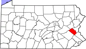 | |
| Boroughs | ||
| Townships | ||
| CDPs | ||
| Unincorporated communities |
| |
| Footnotes | ‡This populated place also has portions in an adjacent county or counties | |
| ||
| Authority control |
|
|---|