Cetronia, Pennsylvania
Cetronia is a census-designated place (CDP) in South Whitehall Township, Lehigh County, Pennsylvania, United States, near the city of Allentown. It includes the unincorporated communities of Cetronia, Sterlingworth, and Park Way Manor.[3] As of the 2010 census the population was 2,115.[2]
Cetronia, Pennsylvania | |
|---|---|
 Location in Lehigh County | |
 Cetronia Location in Pennsylvania  Cetronia Location in the United States | |
| Coordinates: 40°35′8″N 75°32′9″W | |
| Country | United States |
| State | Pennsylvania |
| County | Lehigh |
| Township | South Whitehall |
| Area | |
| • Total | 0.76 sq mi (1.96 km2) |
| • Land | 0.76 sq mi (1.96 km2) |
| • Water | 0.0 sq mi (0.0 km2) |
| Elevation | 363 ft (111 m) |
| Population (2010)[2] | |
| • Total | 2,115 |
| • Density | 2,788/sq mi (1,076.3/km2) |
| Time zone | UTC-5 (EST) |
| • Summer (DST) | UTC-4 (EDT) |
| ZIP code | 18104 |
| Area code(s) | 610 & 484 |
| FIPS code | 42-12424 |
| GNIS feature ID | 2628811 |
Geography
Cetronia is in central Lehigh County, in the southern part of South Whitehall Township. It is bordered to the north by the Allentown city limits and to the southeast by unincorporated Dorneyville and Dorney Park. State Route 1002 (Tilghman Street) runs through Cetronia, Pennsylvania Route 309 forms the western boundary of the community and Cedar Crest Boulevard touches the far east end of it.
Interstate 78 runs southwest of Cetronia prior to its merge with PA Route 309. Interstate 476, the Northeast Extension of the Pennsylvania Turnpike, runs just west of Cetronia, separating it from Krocksville, Ruppsville, and Kuhnsville. US 22, the Lehigh Valley Thruway, passes 1 mile (1.6 km) north of Cetronia, separating it from the Crackersport and Walbert area. I-476 has an interchange with US 22 at the western edge of Cetronia, which uses the Allentown ZIP code of 18104.[4]
According to the U.S. Census Bureau, the Cetronia CDP has an area of 0.77 square miles (2.0 km2), all of it recorded as land.[1] Cedar Creek, an east-flowing tributary of Little Lehigh Creek, forms part of the southern boundary of the CDP. The community is part of the watershed of the Lehigh River, flowing to the Delaware River.
Tilghman Square Shopping Center and a number of restaurants, medical offices, and car dealerships are located in the Cetronia area. The Census Bureau uses 309 and Tilghman Street as the western and northern boundaries of the CDP respectively, however, and therefore most of these businesses are excluded from the CDP definition and totals.
Cetronia Ambulance Corps and the volunteer Cetronia Fire Department provide first responder services to Cetronia and the surrounding area.
| Historical population | |||
|---|---|---|---|
| Census | Pop. | %± | |
| 2000 | 1,952 | — | |
| 2010 | 2,115 | 8.4% | |
References
- "2019 U.S. Gazetteer Files: Places: Pennsylvania". United States Census Bureau. Retrieved October 23, 2020.
- "Total Population: 2010 Census DEC Summary File 1 (P1), Cetronia CDP, Pennsylvania". data.census.gov. U.S. Census Bureau. Retrieved October 23, 2020.
- "Cetronia, Cetronia Census Designated Place, Park Way Manor, PA". U.S. Geological Survey topographic map series. ACME Mapper. Retrieved October 23, 2020.
- "18106 Zip Code Map Allentown Pennsylvania". Hipcodes.com. Retrieved October 23, 2020.
External links
Places adjacent to Cetronia, Pennsylvania | ||||||||||
|---|---|---|---|---|---|---|---|---|---|---|
| ||||||||||
Municipalities and communities of Lehigh County, Pennsylvania, United States | ||
|---|---|---|
| Cities | 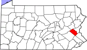 | |
| Boroughs | ||
| Townships | ||
| CDPs | ||
| Unincorporated communities |
| |
| Footnotes | ‡This populated place also has portions in an adjacent county or counties | |
| ||
