New Tripoli, Pennsylvania
New Tripoli (/trɪˈpoʊli/ trih-POH-lee) is an unincorporated community and census-designated place (CDP) in Lynn Township, Lehigh County, Pennsylvania, in the United States. As of the 2010 census the population was 898.[2] New Tripoli is ZIP code 18066 in area code 610, exchange 298.
New Tripoli, Pennsylvania | |
|---|---|
.jpg.webp) | |
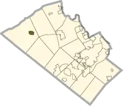 Location in Lehigh County | |
 New Tripoli Location win Pennsylvania  New Tripoli Location in the United States | |
| Coordinates: 40°40′51″N 75°45′07″W | |
| Country | United States |
| State | Pennsylvania |
| County | Lehigh |
| Township | Lynn |
| Area | |
| • Total | 0.92 sq mi (2.38 km2) |
| • Land | 0.92 sq mi (2.37 km2) |
| • Water | 0.0 sq mi (0.0 km2) |
| Elevation | 578 ft (176 m) |
| Population | |
| • Total | 898 |
| • Density | 980/sq mi (378.3/km2) |
| Time zone | UTC-5 (Eastern (EST)) |
| • Summer (DST) | UTC-4 (EDT) |
| ZIP code | 18066 |
| Area code(s) | 610 and 484 (610 Exchange: 298) |
| FIPS code | 42-54288 |
| GNIS feature ID | 1182377[3] |
The name comes from Tripoli in Libya, in commemoration of the fighting in the Barbary Wars.[4] The pronunciation of New Tripoli is with the stress on "PO", as many non-natives make the mistake of stressing the first syllable which will often be corrected by natives.
Geography
The village is located at the intersection of Madison Street and Pennsylvania Route 143 near Pennsylvania Route 309 on the northern edge of the Lehigh Valley region of Pennsylvania. It is in northwestern Lehigh County, in the eastern part of Lynn Township. PA 143 leads east 0.5 miles (0.8 km) to PA 309 and southwest 8 miles (13 km) to Kempton. PA 309 leads southeast 14 miles (23 km) to the west side of the Allentown area and northwest across Blue Mountain 16 miles (26 km) to Tamaqua.
According to the U.S. Census Bureau, the New Tripoli CDP has a total area of 0.93 square miles (2.4 km2), of which 41,340 square feet (3,841 m2), or 0.16%, are water.[2] School Creek flows westward through the north side of town, joining Ontelaunee Creek just west of the CDP border. Water runoff from the town flows via School Creek, Ontelaunee Creek, and Maiden Creek to the Schuylkill River, part of the Delaware River watershed.
Education
The village is served by Northwestern Lehigh School District.
| Historical population | |||
|---|---|---|---|
| Census | Pop. | %± | |
| 2000 | 654 | — | |
| 2010 | 898 | 37.3% | |
References
- "2019 U.S. Gazetteer Files: Places: Pennsylvania". United States Census Bureau. Retrieved October 27, 2020.
- "Total Population: 2010 Census DEC Summary File 1 (P1), New Tripoli CDP, Pennsylvania". data.census.gov. U.S. Census Bureau. Retrieved October 27, 2020.
- "New Tripoli". Geographic Names Information System. United States Geological Survey.
- Espenshade, A. Howry (1925). Pennsylvania place names. State College, PA: The Pennsylvania State College. p. 315.
External links
| Wikimedia Commons has media related to New Tripoli, Pennsylvania. |
- "Lehigh County: Local History" at LehighCounty.org, includes several references to New Tripoli.
- "Lynn-Heidelberg Historical Society" at http://www.lynnheidelberg.org/, includes several references, local events and photos of New Tripoli.
- "New Tripoli separates natives from visitors" at mcall.com, explores the history of the town's unusual pronunciation.
Places adjacent to New Tripoli, Pennsylvania | |
|---|---|
Municipalities and communities of Lehigh County, Pennsylvania, United States | ||
|---|---|---|
| Cities | 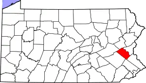 | |
| Boroughs | ||
| Townships | ||
| CDPs | ||
| Unincorporated communities |
| |
| Footnotes | ‡This populated place also has portions in an adjacent county or counties | |
| ||

| Authority control |
|---|