Emeryville station
Emeryville is an Amtrak station in Emeryville, California, United States. The station is served by the California Zephyr, Capitol Corridor, Coast Starlight, and San Joaquins.
Emeryville, CA | ||||||||||||||||||||||||||
|---|---|---|---|---|---|---|---|---|---|---|---|---|---|---|---|---|---|---|---|---|---|---|---|---|---|---|
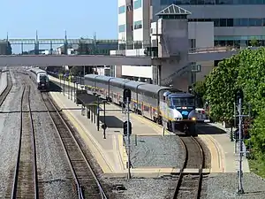 San Joaquins (left) and Capitol Corridor (right) trains at the station | ||||||||||||||||||||||||||
| Location | 5885 Horton Street Emeryville, California | |||||||||||||||||||||||||
| Coordinates | 37.840682°N 122.292477°W | |||||||||||||||||||||||||
| Owned by | City of Emeryville | |||||||||||||||||||||||||
| Line(s) | UP Martinez Subdivision[1] | |||||||||||||||||||||||||
| Platforms | 1 side platform, 1 island platform | |||||||||||||||||||||||||
| Tracks | 5 | |||||||||||||||||||||||||
| Connections | ||||||||||||||||||||||||||
| Construction | ||||||||||||||||||||||||||
| Parking | Free | |||||||||||||||||||||||||
| Bicycle facilities | Yes | |||||||||||||||||||||||||
| Disabled access | Yes | |||||||||||||||||||||||||
| Other information | ||||||||||||||||||||||||||
| Station code | EMY | |||||||||||||||||||||||||
| History | ||||||||||||||||||||||||||
| Opened | August 13, 1993[2] | |||||||||||||||||||||||||
| Passengers | ||||||||||||||||||||||||||
| 2018 | 595,017[3][4] | |||||||||||||||||||||||||
| Rank | 4th in California[3] | |||||||||||||||||||||||||
| Services | ||||||||||||||||||||||||||
| ||||||||||||||||||||||||||
| ||||||||||||||||||||||||||
| Location | ||||||||||||||||||||||||||

| ||||||||||||||||||||||||||
The station is listed as the connection point to San Francisco and Amtrak Thruway Motorcoach buses to and from the city connect every train serving this station.
The station has one side platform and one island platform serving the eastern two tracks of the Union Pacific Railroad Martinez Subdivision.[1] The other three tracks are only used by freight trains. A pedestrian bridge connects the side platform and station building with commercial areas on Shellmound Street to the west.
History
Southern Pacific Railroad
Central Pacific Railroad completed the Berkeley Branch Railroad in 1876, followed by the mainline toward Richmond and beyond in 1878. Stations were located on the mainline at Emerys (Park Avenue), Shellmound, and Montague Street (now 59th Street), plus at San Pablo Avenue on the branch line.[5] By the time the lines were under Southern Pacific Railroad (SP) control a decade later, the Montague Street station was gone and the Emerys (later Emery and Emeryvillle) stop had been moved a block south to Yerba Buena Avenue, where the line crossed the California and Nevada Railroad.[6]
The SP expanded suburban service with its East Bay Electric Lines subsidiary in 1911. Initial electric service to Berkeley mostly used the existing San Pablo Avenue station, with limited stops at Shell Mound, Emery, and B Street (34th Street); non-electric suburban service on the mainline stopped at Shell Mound.[7] Additional branch lines and local stops were later added; by 1932, these stops included Powell Street and Folsom Street on the 9th Street line, and Green Street on the California Street line.[8] The East Bay Electric Lines were closed in July 1941, ending passenger service to Emeryville.
Amtrak
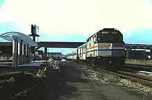
Oakland Central station, Amtrak's primary stop for Oakland (and San Francisco via connecting buses) was damaged in the 1989 Loma Prieta earthquake. A new station was quickly constructed in nearby Emeryville - close to the San Francisco–Oakland Bay Bridge - on the site of a former cement plant. Emeryville station opened on August 13, 1993, though construction was not completed until the next year.[2] Oakland Central station closed on August 5, 1994; Emeryville was the only Oakland-area stop for Amtrak until the new Oakland – Jack London Square station opened on May 22, 1995.[2] The station became a centerpiece of redevelopment of formerly industrial areas of Emeryville. A footbridge connecting the station with parking lots and new development on the west side of the tracks was opened in 1997.[2]
The California Zephyr was re-extended to Oakland with the opening of the Jack London Square station in 1995. However, this required a complicated reverse move along street running tracks to reach the wye at West Oakland. The train was cut back to Emeryville on October 26, 1997.[2]
Bus connections
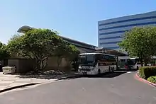
Because Emeryville is closer to the San Francisco–Oakland Bay Bridge than Oakland – Jack London Square station, it is the primary connection point between Amtrak trains and Amtrak Thruway Motorcoach bus service in the Bay Area. Thruway buses run between Emeryville station and downtown San Francisco, providing San Francisco connections for all trains. (However, Oakland is used for San Francisco connections for the southern leg of the Coast Starlight, as well as some Thruway routes that run along the coast to Southern California.)
Several public transit bus lines also serve the station vicinity:
- The free Emery Go-Round Hollis and Hollis South routes stop on Horton Street, across the street from the station, connecting to the Macarthur BART station.
- AC Transit routes 36 and 57 stop on Shellmound Street, across the pedestrian bridge located at the station, while route 29 stops on Hollis Street one block east of the station.
References
- SMA Rail Consulting (April 2016). "California Passenger Rail NETWORK SCHEMATICS" (PDF). California Department of Transportation. p. 13.
- Vurek, Matthew Gerald (2016). Images of Modern America: California’s Capitol Corridor. Arcadia Publishing. pp. 33, 43, 50. ISBN 9781467124171.
- "Amtrak Fact Sheet, Fiscal Year 2018, State of California" (PDF). Amtrak Government Affairs. June 2019. Retrieved June 3, 2020.
- "Amtrak Fact Sheet, Fiscal Year 2017, State of California" (PDF). Amtrak Government Affairs. November 2017. Retrieved June 3, 2020.
- King, Malcolm G. (1876). "Map of Oakland, Alameda and Vicinity, Showing Plan of Streets as Opened and Proposed, Compiled from the most Reliable Public & Private Surveys" – via David Rumsey Map Collection.
- Henkenius, J.C. (1888). "Map of the City of Oakland and Surroundings. Compiled from Official and Private Surveys". Woodward and Gamble – via David Rumsey Map Collection.
- "Time Table for the Western Division Ferries and Suburban Trains" (PDF). Southern Pacific Company. August 1, 1911. pp. 5–6 – via WX4.
- "Time Table for the Western Division - Electric Lines" (PDF). February 28, 1932. p. 12 – via WX4.
External links
| Wikimedia Commons has media related to Emeryville station. |
- Emeryville, CA – Amtrak
- Emeryville Amtrak Station (USA RailGuide -- TrainWeb)
- Emeryville (EMY)--Great American Stations (Amtrak)