Ende Regency
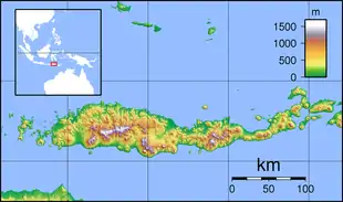
Ende Regency is a regency on the island of Flores, within East Nusa Tenggara Province of Indonesia. The capital is the town of Ende. The regency covers an area of 2,046.62 km2, and as of the 2010 Census it had a population of 260,605;[2] the latest official estimate (for mid 2020) is 274,599.[3]
Ende Regency
Kabupaten Ende | |
|---|---|
 Coat of arms | |
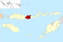 Location within East Nusa Tenggara | |
 Ende Regency  Ende Regency Ende Regency (Lesser Sunda Islands)  Ende Regency Ende Regency (Indonesia) | |
| Coordinates: 8°50′26″S 121°39′50″E | |
| Country | |
| Province | |
| Capital | Ende |
| Government | |
| • Regent | Marselinus Y. W. Petu |
| • Vice Regent | Djafar Achmad |
| Area | |
| • Total | 790.20 sq mi (2,046.62 km2) |
| Population (mid 2020 Estimate) | |
| • Total | 274,599 |
| • Density | 350/sq mi (130/km2) |
| [1] | |
| Time zone | UTC+8 (ICST) |
| Area code | (+62) 381 |
| Website | endekab |
The Kelimutu National Park which contains the well-known tourist attraction of Mount Kelimutu with three coloured lakes is in Ende Regency.
Administration
The regency is divided into twenty-one districts (kecamatan), tabulated below with their areas and their 2010 Census population[4] and the official estimates for mid-2018.[5] The table also includes the number of villages (rural desa and urban kelurahan) in each district, and its post code.
| Name | Area in km2 | Population Census 2010 | Population Estimate mid 2018 | Number of villages | Post codes |
|---|---|---|---|---|---|
| Nangapanda | 185.90 | 19,842 | 20,822 | 29 | 86351 |
| Pulau Ende (Ende Island) | 9.98 | 7,754 | 8,036 | 9 | 86362 |
| Maukaro | 218.00 | 6,967 | 7,303 | 11 | 86352 |
| Ende | 164.47 | 15,062 | 15,852 | 32 | 86319 |
| Ende Selatan (South Ende) | 19.12 | 23,869 | 24,969 | 5 | 86313 -86316 |
| Ende Timur (East Ende) | 19.34 | 19,808 | 20,556 | 6 | 86312 -86319 |
| Ende Tengah (Central Ende) | 5.67 | 27,942 | 29,384 | 4 | 86312 -86319 |
| Ende Utara (North Ende) | 16.80 | 18,100 | 18,985 | 10 | 86310 |
| Ndona | 93.58 | 12,392 | 12,873 | 14 | 86360 |
| Ndona Timur (East Ndona) | 52.48 | 5,062 | 5,350 | 7 | 86363 |
| Wolowaru | 63.81 | 16,051 | 16,728 | 17 | 86373 |
| Wolojita | 39.40 | 6,200 | 6,518 | 6 | 86382 |
| Lio Timur (East Lio) | 55.91 | 7,233 | 7,688 | 13 | 86361 |
| Kelimutu | 52.09 | 7,604 | 6,934 | 9 | 86318 |
| Ndori | 26.39 | 5,128 | 5,352 | 10 | 86362 |
| Maurole | 154.43 | 11,396 | 11,888 | 13 | 86381 |
| Kotabaru | 213.56 | 12,606 | 10,559 | 13 | 86111 |
| Detukeli | 137.13 | 6,787 | 6,721 | 13 | 86371 |
| Lepembuso Kelisoke (a) | 103.21 | (a) | 5,552 | 14 | 86374 -86379 |
| Detusoko | 142.30 | 13,320 | 13,647 | 21 | 86370 |
| Wewaria | 294.18 | 16,492 | 17,271 | 22 | 86353 |
| Totals | 2,046.62 | 260,605 | 272,988 | 278 |
Note: (a) a new district created since 2010 by splitting of existing neighbouring districts. (b) 2010 population included with the figure for the districts from which it was split.
References
- Badan Pusat Statistik, Jakarta, 2020.
- Biro Pusat Statistik, Jakarta, 2011.
- Badan Pusat Statistik, Jakarta, 2020.
- Biro Pusat Statistik, Jakarta, 2011.
- Badan Pusat Statistik, Jakarta, 2020.
External links
Regencies and cities of East Nusa Tenggara | ||
|---|---|---|
Capital: Kupang | ||
| Regencies |  | |
| Cities | ||