Kupang Regency
Kupang Regency is a regency in East Nusa Tenggara province of Indonesia. It occupies the far western end of Timor Island (apart from the area of Kupang city, which is administratively separate), together with the small offshore island of Semau (off the western tip of Timor). Other islands to the southwest and west which were formerly part of Kupang Regency have been separated administratively - the Rote Islands Group in 2002 (to form Rote Ndao Regency), and the Savu Islands in October 2008 (to form Sabu Raijua Regency). The capital of Kupang Regency is at Oelamasi.[2]
Kupang Regency
Kabupaten Kupang | |
|---|---|
 Seal | |
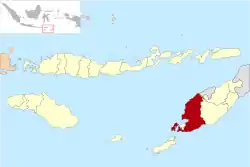 Location within East Nusa Tenggara | |
 Kupang Regency  Kupang Regency Kupang Regency (Lesser Sunda Islands)  Kupang Regency Kupang Regency (Indonesia) | |
| Coordinates: 10°18′S 123°43′E | |
| Country | |
| Region | Lesser Sunda Islands |
| Province | |
| Capital | Oelamasi |
| Government | |
| • Regent | Korinus Masneno |
| • Vice Regent | Jerry Manafe |
| Area | |
| • Total | 2,133.53 sq mi (5,525.83 km2) |
| Population (2019) | |
| • Total | 403,582 |
| [1] | |
| Time zone | UTC+8 (ICST) |
| Area code | (+62) 380 |
| Website | |
Administration
The regency is divided into twenty-four districts (kecamatan), tabulated below with their areas and their 2010 Census population[3] and the official estimates for mid-2019.[4] Thew table also includes the number of villages (rural desa / urban kelurahan) in each district.
| Name | English name | Area in km2 | Population Census 2010 | Population Estimate mid 2019 | Number of desa / kelurahan |
|---|---|---|---|---|---|
| Semau | Semau Island (North) | 143.42 | 6,688 | 7,749 | 8 / - |
| Semau Selatan | South Semau Island | 105.24 | 4,731 | 5,696 | 6 / - |
| Kupang Barat | West Kupang | 149.72 | 15,417 | 20,153 | 10 / 2 |
| Nekamese | 122.44 | 9,010 | 10,255 | 11 / - | |
| Kupang Tengah | Central Kupang | 103.46 | 33,805 | 57,394 | 7 / 1 |
| Taebenu | 106.89 | 14,594 | 20,712 | 8 / - | |
| Amarasi | 737.47 | 15,279 | 17,751 | 8 / 1 | |
| Amarasi Barat | West Amarasi | 246.47 | 14,375 | 16,101 | 7 / 1 |
| Amarasi Selatan | South Amarasi | 172.81 | 10,276 | 11,801 | 3 / 2 |
| Amarasi Timur | East Amarasi | 162.91 | 7,054 | 8,499 | 4 / - |
| Kupang Timur | East Kupang | 160.99 | 40,525 | 69,128 | 8 / 5 |
| Amabi Oefeto Timur | East Amabi Oefeto | 13,059 | 14,721 | 10 / - | |
| Amabi Oefeto | Amabi Oefeto | 7,747 | 9,719 | 7 / - | |
| Sulamu | 14,200 | 17,003 | 6 / 1 | ||
| Fatuleu | 23,007 | 28,948 | 9 / 1 | ||
| Fatuleu Barat | West Fatuleu | 8,399 | 10,187 | 5 / - | |
| Fatuleu Tengah | Central Fatuleu | 4,885 | 6,146 | 4 / - | |
| Takari | 20,262 | 23,252 | 9 / 1 | ||
| Amfoang Selatan | South Amfoang | 8,628 | 9,804 | 6 / 1 | |
| Amfoang Barat Daya | Southwest Amfoang | 4,263 | 4,994 | 4 / - | |
| Amfoang Barat Laut | Northwest Amfoang | 8,762 | 9,786 | 6 / - | |
| Amfoang Utara | North Amfoang | 7,004 | 7,842 | 5 / 1 | |
| Amfoang Timur | East Amfoang | 7,101 | 9,605 | 5 / - | |
| Amfoang Tengah | Central Amfoang | 5,397 | 6,336 | 4 / - | |
| Totals | 5,525.83 | 304,548 | 403,582 | 160 / 17 |
References
- Badan Pusat Statistik, Jakarta, 2020.
- Government of Indonesia (9 August 1958), Establishment of the Second-level Administrative Regions under the First-level Administrative Region of Bali, West Nusa Tenggara and East Nusa Tenggara (in Indonesian), Indonesia Ministry of Law and Justice, UU No. 69/1958
- Biro Pusat Statistik, Jakarta, 2011.
- Badan Pusat Statistik, Jakarta, 2020.
External links
Regencies and cities of East Nusa Tenggara | ||
|---|---|---|
Capital: Kupang | ||
| Regencies |  | |
| Cities | ||