Felipe González de Ahedo
Felipe González de Ahedo, also spelled Phelipe González y Haedo (13 May 1714 in Santoña, Cantabria – 26 October 1802), was a Spanish navigator and cartographer known for annexing Easter Island in 1770.
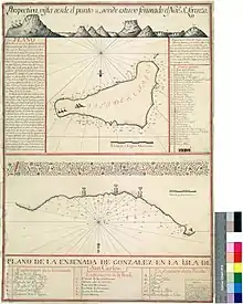
González de Ahedo commanded two Spanish ships, the San Lorenzo and the Santa Rosalia, sent by the Viceroy of Peru, Manuel de Amat y Juniet. They landed on 1770 November 15, only the second time European had seen Easter Island, and stayed five days, thoroughly surveyed the coast, and named it Isla de San Carlos, taking possession on behalf of King Charles III of Spain. They ceremoniously signed a treaty of annexation with the inhabitants and erected three wooden crosses on top of three small hills on Poike volcano.[2]
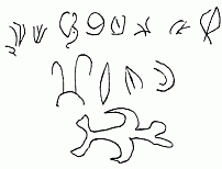
They were amazed by the "standing idols", moai, all of which they could see were erect.[3]
Notes
- These were traced from the original, which has since been lost, and so may not retain their original orientations. They were published with the long line vertical on the left, and the large glyph upright on the right.[1]
References
- Corney, Bolton Glanvill, ed. (1903). The voyage of Captain Don Felipe González in the ship of the line San Lorenzo, with the frigate Santa Rosalia in company, to Easter Island in 1770-1. Preceded by an extract from Mynheer Jacob Roggeveen's official log of his discovery of and visit to Easter Island in 1722. Cambridge: Hakluyt Society. p. plate between pp 48 & 49.
- Jo Anne Van Tilburg. Easter Island: Archaeology, Ecology and Culture. British Museum Press, London, 1994. ISBN 0-7141-2504-0
- Fischer, Steven (2005). Island at the End of the World. London: Reaktion Books Ltd. pp. 60–64. ISBN 9781861892829.
| Authority control |
|---|