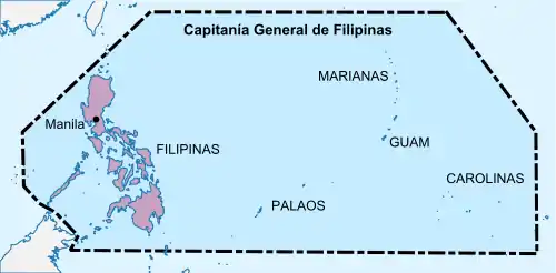
Captaincy General of the Philippines
The Captaincy General of the Philippines (Spanish: Capitanía General de Filipinas Spanish pronunciation: [kapitaˈni.a xeneˈɾal ðe filiˈpinas] (![]() listen); Filipino: Kapitaniya Heneral ng Pilipinas), was an administrative district of the Spanish Empire in Southeast Asia governed by a Governor-General. The Captaincy General encompassed the Spanish East Indies, which included among others the Philippine Islands and the Caroline Islands. It was founded in 1565 with the first permanent Spanish settlements.
listen); Filipino: Kapitaniya Heneral ng Pilipinas), was an administrative district of the Spanish Empire in Southeast Asia governed by a Governor-General. The Captaincy General encompassed the Spanish East Indies, which included among others the Philippine Islands and the Caroline Islands. It was founded in 1565 with the first permanent Spanish settlements.
.svg.png.webp)

For centuries, all the political and economic aspects of the Captaincy General were administered in Mexico City by the Viceroyalty of New Spain, while the administrative issues had to be consulted with the Spanish Crown or the Council of the Indies through the Royal Audience of Manila. However, in 1821, following the independence of Mexico, all control was transferred to Madrid. It was succeeded by the short-lived First Philippine Republic following its independence through the Philippine Revolution.
History
Early explorations
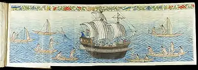
After a long, tolling voyage across the Pacific Ocean, Ferdinand Magellan reached the island of Guam on March 6, 1521 and anchored the three ships that were left of his fleet in Umatac Bay, before proceeding to the Philippines, where he met his death during the Battle of Mactan. Antonio Pigafetta, the expedition's chronicler and one of only 18 original crew members to survive Ferdinand Magellan's circumnavigation of the globe, recorded all details of the voyage.
Miguel López de Legazpi arrived in Umatac in 1565 and claimed the island of Guam for Spain, before proceeding to the Philippines, where, in a short period of time, they successfully incorporated into Spain's empire Cebu, Samar, Mazaua, Leyte, and Bohol, before conquering Manila.
Later (in 1569), Miguel López de Legazpi transferred the Spanish headquarters from Cebu to Panay, where they found allies, who were never conquered by Spain but were accomplished as vassals by means of pacts, peace treaties, and reciprocal alliances.[1] On 5 June 1569, Guido de Lavezaris, the royal treasurer in the archipelago, wrote to Philip II reporting about the Portuguese attack on Cebu in the preceding autumn. A letter from another official, Andres de Mirandaola (dated three days later, on 8 June), also described briefly this encounter with the Portuguese. The danger of another attack led the Spaniards to remove their camp from Cebu to Panay, which they considered a safer place. Legazpi himself, in his report to the Viceroy in New Spain (dated 1 July 1569), mentioned the same reason for the relocation of Spaniards to Panay.[2] It was in Panay that the conquest of Luzon was planned, and launched on 8 May 1570.[3] Two of Lepazpi's lieutenant-commanders, Martín de Goiti and Juan de Salcedo, conquered Luzon's northern region.
Several Pacific islands were claimed by Spain during the 16th century, including the Caroline Islands by Toribio Alonso de Salazar in 1526, Palau by Ruy López de Villalobos in 1543, Bonin Islands by Bernardo de la Torre in 1543, New Guinea by Yñigo Ortiz de Retez in 1545, Solomon Islands by Pedro Sarmiento de Gamboa in 1568, New Hebrides by Pedro Fernandes de Queirós in 1606, and Marquesas Islands by Álvaro de Mendaña de Neira in 1595, although Spain did not make any serious attempt to establish permanent settlements in them until the 18th century.
Spanish settlement and creation of the Captaincy General
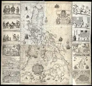
In 1574, the Captaincy General of the Philippines was created as a dependency of the Viceroyalty of New Spain. In 1584, the Real Audiencia of Manila was established by King Felipe II, who appointed as its President the same governor of the Captaincy General of the Philippines. The Captaincy General had its capital in Cebu from 1565 to 1595, and in Manila from 1595 until 1898.
As part of the extensive governmental reforms during the early Bourbon period throughout the overseas possessions, an Intendencia was established in Manila by Royal Decree of July 17, 1784 that handled issues regarding the government finances and to promote the economy. Ciriaco González Carbajal was appointed as Oidor of the Audiencia of Manila and was instructed to abide by the Royal Ordinance of Mayors of 1782, that had been enacted in Rio de la Plata. Carbajal proposed the establishment of more Intendencias in Ilocos, Camarines, Iloilo and Cebu, and although they were created on November 24, 1786, they were later abolished by the Royal Decree of November 20, 1787.[4] A month earlier, on October 23, the Intendencia of Manila had been attached to the Captaincy General of the Philippines.[5]
Until 1822, all General Captains were civilians, but after that year they were always chosen among the military. Throughout the second half of the 19th century, there were established many dependent local government offices and military settlements, very numerous due to a large number of islands and the extent of the districts.
Territorial divisions
Until the second half of the 18th century, there were 24 provinces, 19 alcaldías mayores and five corregimientos:[6]
Corregimientos
- Mariveles
- Cavite
- Zamboanga
- Mindanao Moro
- Ogtong (Oton)
Alcaldías mayores
Other administrative units established afterward
- Zambales (separated from Pangasinán)
- Bataan (separated from Mariveles and from Pampanga in 1754)
- Nueva Écija (separated from Pampanga)
- Nueva Vizcaya (separated from Cagayán in 1839)
- Ilocos Norte (divided in two from Ilocos in 1818)
- Ilocos Sur (divided in two from Ilocos in 1818)
- Camarines Norte (divided in two from Camarines in 1829)
- Camarines Sur (divided in two from Camarines in 1829)
- Samar (separated from Leite)
- Misamis (separated from Mindanao Moro and from Cebú)
- Iloílo (separated from Panay)
- Antique (separated from Panay)
- Abra (separated from Ilocos Sur in 1846)
- Nueva Guipúzcoa (separated from Caraga in 1847)
- Ticao and Masbate (separated from Albay in 1846)
- La Unión (separated from Pangasinán and Ilocos Sur in 1850)
- Lower territories of Agno (Military outposts)
Established during the 19th century
Until the second half of the 19th century, there existed the administrative units:
- Luzon Island (20 administrative units): Tondo, Bulacán, Pampanga, Zambales, Bataan, Nueva Écija, La Unión, Cavite, Laguna, Batangas, Pangasinan, Ilocos Norte, Ilocos Sur, Tayabas, Abra, Cagayán (including Babuyan Islands), Nueva Vizcaya, Albay, Camarines Norte, Camarines Sur.
- Mindoro, Marinduque, Luban, Ilin (one administrative unit): Mindoro.
- Batán (one administrative unit): Batanes.
- Panay Island (three administrative units): Cápiz, Iloilo, Antique.
- Negros (one administrative unit): Negros.
- Samar (one administrative unit): Samar.
- Leite (one administrative unit): Leite.
- Calamianes (one administrative unit): Calamianes.
- Cebú (one administrative unit): Cebú.
- Mindanao (four administrative units): Caraga, Misamis, Zamboanga, Nueva Guipúzcoa.
- Sultanate of Sulu
- Joló
- Marianas (one administrative unit): Marianas capital, Agaña, Guam.
- Palau
- Bonin Islands
- Spratly Islands
- Caroline Islands
- Marshall Islands
- Special Districts (four): Benguet, Ticao and Masbate, Comandancia del Corregidor, Lower territories of Agno.
Spanish rule in the Philippines ceased in 1898 after the war with the United States, which annexed most territories, although the administrative jurisdictions remained intact.
Most of the remaining territories in the Pacific Ocean were sold to Germany during the German-Spanish Treaty of 1899.
See also
- History of the Philippines (1521–1898)
- Spanish East Indies
- Spanish Filipino
- New Spain
- Governor-General of the Philippines
- Royal Audience of Manila
- Spanish Empire
- Viceroyalty of New Spain
- History of the Philippines
References
- Cf. William Henry Scott, Cracks in the Parchment Curtain, Quezon City: 1998, p. 4. Also cf. Antonio Morga, Sucessos de las Islas Filipinas, 2nd ed., Paris: 1890, p. xxxiii.
- Cf. Blair, Emma Helen & Robertson, James Alexander, eds. (1911). The Philippine Islands, 1493–1803. Volume 03 of 55 (1493-1803). Historical introduction and additional notes by Edward Gaylord Bourne. Cleveland, Ohio: Arthur H. Clark Company. ISBN 978-0554259598. OCLC 769945704. "Explorations by early navigators, descriptions of the islands and their peoples, their history and records of the catholic missions, as related in contemporaneous books and manuscripts, showing the political, economic, commercial and religious conditions of those islands from their earliest relations with European nations to the beginning of the nineteenth century.", pp. 15–16.
- Cf. Blair, Emma Helen & Robertson, James Alexander, eds. (1911). The Philippine Islands, 1493–1803. Volume 03 of 55 (1493-1803). Historical introduction and additional notes by Edward Gaylord Bourne. Cleveland, Ohio: Arthur H. Clark Company. ISBN 978-0554259598. OCLC 769945704. "Explorations by early navigators, descriptions of the islands and their peoples, their history and records of the catholic missions, as related in contemporaneous books and manuscripts, showing the political, economic, commercial and religious conditions of those islands from their earliest relations with European nations to the beginning of the nineteenth century.", p. 73.
- Enciclopedia GER Archived July 23, 2011, at the Wayback Machine
- Biblioteca de legislación ultramarina en forma de diccionario alfabético. Pág. 621. Compilado por: José María Zamora y Coronado. Editor: Impr. de J. M. Alegria, 1845
- Memorias históricas y estadísticas de Filipinas y particularmente de la grande isla de Luzon. Author: Rafael Díaz Arenas. Publicado por Imprenta del Diario de Manila, 1830
| |
| |
| |
| |
| |
|