Grade II* listed buildings in Newport
In the United Kingdom, the term listed building refers to a building or other structure officially designated as being of special architectural, historical, or cultural significance; Grade II* structures are those considered to be "particularly important buildings of more than special interest".[1] Listing was begun by a provision in the Town and Country Planning Act 1947. Once listed, strict limitations are imposed on the modifications allowed to a building's structure or fittings. In Wales, the authority for listing under the Planning (Listed Buildings and Conservation Areas) Act 1990[2] rests with Cadw.
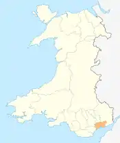
Newport shown within Wales
Buildings
| Name | Location | Date Listed | Grid Ref.[note 1] Geo-coordinates |
Function | Notes | Reference Number | Image |
|---|---|---|---|---|---|---|---|
| Pencoed Castle | Langstone | 3 March 1952 | ST4062689401 51°36′01″N 2°51′31″W |
Located at the end of a narrow lane from by-road off B4245, approx 1km S of Llandevaud village and 1km E of Llanmartin. | 2904 | 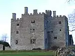 | |
| Plas Machen | Graig | 3 March 1952 | ST2346787539 51°34′53″N 3°06′21″W |
At the end of a track S off the A468, some 900m Se of the church at Lower Machen. | 2905 |  | |
| Church of Saint Basil | Graig | 3 January 1963 | ST2773587124 51°34′42″N 3°02′39″W |
On the E side of Bassaleg, on the N side of the churchyard some 75m W of the Ebbw River. | 2913 | 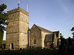 | |
| Kemeys Manor | Langstone | 3 January 1963 | ST3820192597 51°37′44″N 2°53′39″W |
Set on the E side of the A449. Located on the W slope of the steep escarpment of Kemeys Graig, immediately to the S of the A449. Set at the end of a long private drive overlooking the River Usk on a lane leading from Llantrisant to Langstone. | 2916 | | |
| Church of St Mary | Llanwern | 3 January 1963 | ST3706287865 51°35′10″N 2°54′35″W |
Located on the S side of the Lane leading from Llanwern village to Bishton at the junction of the driveway to Barn Farm. Immediately to the N of the Spencer steelworks | 2926 | 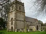 | |
| Church of Saint Michael | Graig | 3 January 1963 | ST2279988081 51°35′11″N 3°06′56″W |
In a prominent position in the centre of Lower Machen Conservation Area. | 2927 | 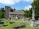 | |
| Church of St Mary | Marshfield | 3 January 1963 | ST2616682573 51°32′14″N 3°03′57″W |
Set on the N side of Church Lane opposite Church Farm, leading off Marshfield Road. The church is surrounded by a low rubble wall with cock and hen coping; lych gate to W and remains of medieval cross base to S, now with modern timber cross.[3][4] | 2932 | 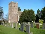 | |
| Church of St Michael | Michaelston-y-Fedw | 3 January 1963 | ST2406684598 51°33′19″N 3°05′48″W |
Located at the W side of the village, within a C19 walled enclosure, set behind the public house. | 2935 | _St_Michael's_Church_-_geograph.org.uk_-_69897.jpg.webp) | |
| Church of St Bridget | Wentlooge | 3 January 1963 | ST2923682298 51°32′07″N 3°01′18″W |
Located on the W side of Church Road, opposite Church Farm, set down a small track. | 2941 | .jpg.webp) | |
| Church of St Mary | Whitson | 3 January 1963 | ST3807383439 51°32′47″N 2°53′40″W |
In churchyard reached by drive approximately 300m E of junction with Whitson Common Road. Now redundant. | 2943 | 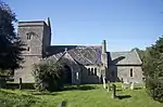 | |
| Whitson Court | Whitson | 3 January 1963 | ST3711484709 51°33′28″N 2°54′31″W |
Set back on E side of road 800m S of electricity substation. | 2944 | 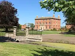 | |
| Church of St Cadoc | Caerleon | 7 November 1951 | ST3393990642 51°36′39″N 2°57′19″W |
In the centre of Caerleon village immediately north of the National Roman Legion Museum.[5][6] | 2948 | 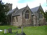 | |
| The Endowed School | Caerleon | 7 November 1951 | ST3388790583 51°36′37″N 2°57′22″W |
About 80m south west of the Church of St Cadoc in the centre of Caerleon. | 2984 | 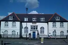 | |
| Tower to the south west of, and attached to, The Hanbury Arms | Caerleon | 7 January 1951 | ST3416590372 51°36′30″N 2°57′08″W |
Attached to the south west corner of The Hanbury Arms. | 2996 | 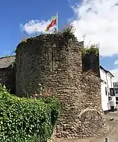 | |
| Newport Castle | Stow Hill | 26 July 1951 | ST3116288449 51°35′26″N 2°59′42″W |
Beside River Usk in angle formed by Newport Bridge and Old Green Interchange. | 2997 | 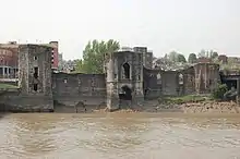 | |
| Penhow Castle | Penhow | 3 January 1963 | ST4236890867 51°36′49″N 2°50′01″W |
Set high on a hilltop above the Newport to Chepstow road. In its own grounds beyond the Parish Church and reached by drive with relocated stone gatepiers and distinctive ball finials. | 3078 | 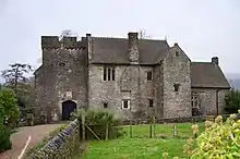 | |
| Machen House including attached outbuildings and curved screen wall | Graig | 10 April 1990 | ST2273088077 51°35′11″N 3°07′00″W |
In the centre of the village immediately to W of the Parish Church. Set in its own landscaped grounds and reached by short drive with gate piers. | 3084 | .jpg.webp) | |
| Gatehouse at Pencoed Castle | Langstone | 19 December 1995 | ST4060089456 51°36′03″N 2°51′32″W |
Located at the front of the castle which is at the end of a narrow lane from by-road off the B4245, approx 1km S of Llandevaud village and 1km E of Llanmartin. | 17076 | .jpg.webp) | |
| Edney Gates at Tredegar House | Coedkernew | 3 January 1963 | ST2878285285 51°33′43″N 3°01′44″W |
Middle Court is located immediately to the northwest of Tredegar House separating it from the Stable Court, the Edney Gates and screen are set at the north end dividing the house and Stable Court. | 17097 | 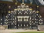 | |
| Boundary walls to Orangery and Cedar gardens at Tredegar House | Coedkernew | 3 January 1963 | ST2870485208 51°33′41″N 3°01′48″W |
Set immediately to the west of Tredegar House and the Orangery, enclosing the Cedar Garden and the Orangery Garden. Set of brick piers set at the north end of the Orangery Garden, the south of the Cedar Garden and a central pair linking the two garden courtyard | 17098 | 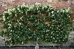 | |
| Newport Civic Centre | Allt yr yn | 14 September 1999 | ST3043888224 51°35′19″N 3°00′20″W |
Occupies a large prominent site S of Fields Road, bounded by Godfrey Road (E), Faulkner Road (S), and Clytha Park Road to the W. | 22333 |  | |
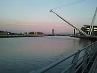
| George Street Bridge | Victoria, Newport | 31 October 2001 | ST3191687734 51°35′04″N 2°59′03″W |
Spans River Usk between Corporation Road and Dock Street. | 25847 | 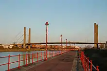 | |
| Railway viaduct over Ebbw River | Rogerstone | 23 July 2003 | ST2782187203 51°34′45″N 3°02′35″W |
Crossing the Ebbw River from E to W on the NE side of Bassaleg. | 81343 | 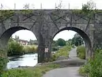 |
Notes
- Sometimes known as OSGB36, the grid reference is based on the British national grid reference system used by the Ordnance Survey.
See also
References
- "Buildings & Conservation Areas". Cadw. Retrieved 18 June 2013.
- "Planning (Listed Buildings and Conservation Areas) Act 1990". The National Archives. Retrieved 18 June 2013.
- Cadw. "Parish Church of St Mary (2932)". National Historic Assets of Wales. Retrieved 9 April 2019.
- "Parish Church of St Mary". British Listed Buildings. Retrieved 9 April 2019.
- Cadw. "Church of St. Cadoc (2948)". National Historic Assets of Wales. Retrieved 9 April 2019.
- "Church of St. Cadoc". British Listed Buildings. Retrieved 9 April 2019.
External links
![]() Media related to Grade II* listed buildings in Newport, Wales at Wikimedia Commons
Media related to Grade II* listed buildings in Newport, Wales at Wikimedia Commons
This article is issued from Wikipedia. The text is licensed under Creative Commons - Attribution - Sharealike. Additional terms may apply for the media files.
