Grade II* listed buildings in the Vale of Glamorgan
In the United Kingdom, the term listed building refers to a building or other structure officially designated as being of special architectural, historical, or cultural significance; Grade II* structures are those considered to be "particularly important buildings of more than special interest".[1] Listing was begun by a provision in the Town and Country Planning Act 1947. Once listed, strict limitations are imposed on the modifications allowed to a building's structure or fittings. In Wales, the authority for listing under the Planning (Listed Buildings and Conservation Areas) Act 1990[2] rests with Cadw.
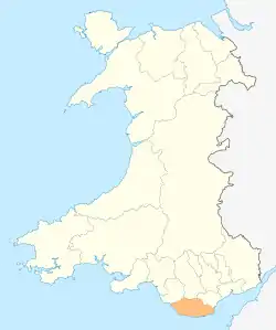
The Vale of Glamorgan shown within Wales
Buildings
| Name | Location | Date Listed | Grid Ref.[note 1] Geo-coordinates |
Function | Notes | Reference Number | Image |
|---|---|---|---|---|---|---|---|
| Church of St James | Wick | 26 July 1963 | SS9233072180 51°26′18″N 3°33′02″W |
Church | Located on the N side of Church Street in the centre of Wick Village. Located in a roughly rectangular churchyard. | 11221 |  |
| Church of St Bridget | St Brides Major | 26 July 1963 | SS8941375010 51°27′48″N 3°35′36″W |
Church | Set within a polygonal churchyard on the hillside, towards the NW end of St. Brides Major. | 11226 |  |
| Ewenny Priory (house) | Ewenny | 26 July 1963 | SS9124677776 51°29′18″N 3°34′04″W |
Church | About 1km northeast of Ewenny village, a five-bay Georgian mansion to south of Ewenny Priory. | 11249 | 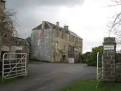 |
| Flemingston Court Farmhouse | St Athan | 16 December 1952 | ST0169370023 51°25′14″N 3°24′55″W |
Farmhouse | On the south side of the Churchyard of the Church of St Michael the Archangel. | 13130 |  |
| Gileston Manor | Gileston (St Athan) | 16 December 1952 | ST0176667072 51°23′39″N 3°24′48″W |
House | In the centre of Gileston village and immediately west of the Church of St Giles. | 13131 | .jpg.webp) |
| Great House (Ty Mawr), Aberthin | Aberthin | 16 December 1952 | ST0107875288 51°28′04″N 3°25′32″W |
House | In large walled garden about 300m E of centre of Aberthin; on N side of Nant Aberthin. | 13132 | %252C_Aberthin_2.png.webp) |
| Llanmaes House | Llan Maes | 16 December 1952 | SS9812569487 51°24′55″N 3°27′59″W |
House | In the centre of Llanmaes village facing the east end of the Church of St. Cattwg. | 13134 |  |
| Castleton Farmhouse | St Athan | 16 December 1952 | ST0240668376 51°24′22″N 3°24′16″W |
Farmhouse | About 700m north-east of the Church of St. Athan and approached down a cul-de-sac. | 13140 | |
| Parish church of St Michael and All Angels, Llanmihangel | Llanmihangel, Llandow | 22 February 1963 | SS9813571886 51°26′12″N 3°28′01″W |
Church | 13141 |  | |
| Church of St Brise | St Athan | 22 February 1963 | ST0056269124 51°24′45″N 3°25′52″W |
Church | It is within the boundary fence of RAF St Athan on the south side of a right-angled bend in the road and hidden by trees. | 13142 | |
| Church of St Giles | Gileston (St Athan) | 22 February 1963 | ST0178767081 51°23′39″N 3°24′47″W |
Church | In the centre of Gileston village and immediately to the east of Gileston Manor. | 13143 |  |
| St Quintin's Castle (Llanblethian Castle) | Cowbridge with Llanblethian | 22 February 1963 | SS9891074177 51°27′27″N 3°27′23″W |
Castle | About 450m NE of Llanblethian church on spur of land above loop in River Thaw. | 13146 | 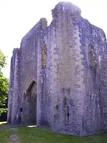 |
| Parish church of the Holy Trinity, Ty Draw | Llandow | 22 February 1963 | SS9423073322 51°26′56″N 3°31′24″W |
Church | 13148 |  | |
| Church Farmhouse (also known as The Glebe) | Llandow | 22 February 1963 | SS9422673353 51°26′57″N 3°31′25″W |
Farmhouse | Situated immediately to the NE of the Parish Church of Holy Trinity, in the centre of Llandow village. Set within its own gardens to front and rear, bounded by a low rubble wall. | 13149 | |
| Sutton Farmhouse | Llandow | 22 February 1963 | SS9445972320 51°26′24″N 3°31′12″W |
Farmhouse | 13151 | | |
| Church of St Cattwg | Llan Maes | 22 February 1963 | SS9807469486 51°24′55″N 3°28′01″W |
Church | In the centre of Llanmaes village. | 13160 | 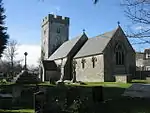 |
| Church of St Brynach | Penllyn | 22 February 1963 | SS9794574610 51°27′41″N 3°28′13″W |
Church | At the very southern point of the community and about 1.5 km south of Penllyn village. | 13164 |  |
| Church of St Hilary | St Hilary (Llanfair) | 22 February 1963 | ST0161473263 51°26′59″N 3°25′02″W |
Church | 13170 | .JPG.webp) | |
| Old Beaupre Farmhouse | Llanfair | 22 February 1963 | ST0087972050 51°26′20″N 3°25′39″W |
Farmhouse | Located at the SE corner of Old Beaupre Castle, attached to the E end of the S range of the ruined manor house, aligned on a N/S axis. | 13172 |  |
| Church of St Cadoc, Cadoxton | Cadoxton, Barry | 18 September 1962 | ST1299269347 51°24′59″N 3°15′09″W |
Church | 13175 | 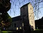 | |
| Church of St Dyfran and St Teilo, Merthyr Dyfan | Merthyr Dyfan, Barry | 18 September 1962 | ST1149569458 51°25′02″N 3°16′27″W |
Church | 13177 | 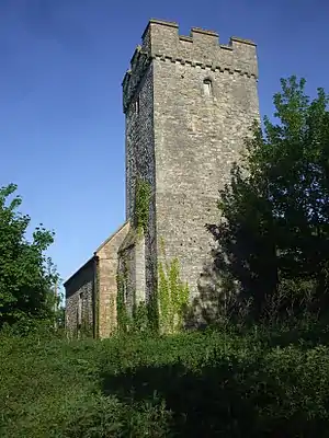 | |
| Barry Castle | Barry | 18 September 1962 | ST1008667197 51°23′48″N 3°17′38″W |
Castle | Remains of a fortified manor dating from circa 1300-1350. At junction of Porth-y-Castell and Park Road, Barry.[3][4] | 13180 | 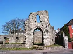 |
| Cowbridge town walls | Cowbridge with Llanblethian | 12 May 1963 | SS9926874618 51°27′42″N 3°27′05″W |
Town wall | On east side of The Butts, from rear of Mason's Arms, to bastion at southwest angle, thence along north side of Town Mill Road. | 13181 | 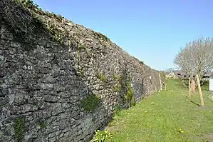 |
| South Gate (Porth y Felin) | Cowbridge with Llanblethian | 12 May 1963 | SS9932774574 51°27′40″N 3°27′02″W |
Gate | At south end of Church Street. | 13183 | .JPG.webp) |
| Cowbridge Grammar School | Cowbridge with Llanblethian | 18 April 1973 | SS9934974581 51°27′40″N 3°27′01″W |
Apartments | To south of Parish Church. | 13185 |  |
| Cowbridge Town Hall | Cowbridge | 12 May 1963 | SS9956874653 51°27′43″N 3°26′49″W |
Town hall | Prominently sited near the east end of High Street, with rear elevations to Town Hall Square. | 13200 | 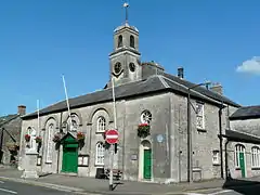 |
| The Great House, Cowbridge | Cowbridge | 12 May 1963 | SS9948574646 51°27′43″N 3°26′54″W |
16th century L-shaped hall house, two storeys with attic, about 80m east of junction with Church Street.[5][6] | 13221 | | |
| Boverton Place including attached bee-boles | Llantwit Major | 9 October 1982 | SS9825868342 51°24′18″N 3°27′51″W |
On the south side of Boverton village centre. | 13245 | 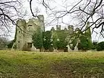 | |
| Llantwit Major Town Hall | Llantwit Major | 22 February 1963 | SS9673868717 51°24′29″N 3°29′10″W |
Town hall | In the centre of Llantwit Major. | 13248 | 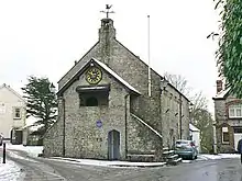 |
| Dovecote, Llantwit Major | Llantwit Major | 22 February 1963 | SS9655068603 51°24′25″N 3°29′19″W |
Dovecote | About 110m south-west of the Church of St. Illtud. | 13253 | 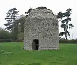 |
| The Gatehouse, Llantwit Major | Llantwit Major | 22 February 1963 | SS9656468661 51°24′27″N 3°29′19″W |
Gatehouse | About 80m south-west of the Church of St. Illtud. The building is on the roadside and is sited near the south-east corner of the 'Monastery' field. | 13254 |  |
| Old Swan Inn, Llantwit Major | Llantwit Major | 16 December 1952 | SS9674368740 51°24′30″N 3°29′10″W |
Public house | In the centre of Llantwit Major just to the north of The Town Hall. | 13260 | .jpg.webp) |
| Ty-Mawr (or Great House) | Llantwit Major | 22 February 1963 | SS9669269223 51°24′45″N 3°29′13″W |
About 500m north of the Church of St. Illtud at the northern entrance to the town. | 13271 | 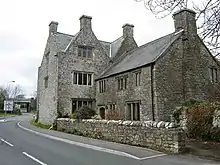 | |
| Church of St Mary, St Donats | Monknash, St Donats | 22 February 1963 | SS9210770468 51°25′23″N 3°33′11″W |
Church | About 200m east of the road junction in the centre of Monknash on the south side of the road going towards St Donats. | 13311 |  |
| St Peter's Church, Penarth | Penarth | 19 November 1990 | ST1687570568 51°25′41″N 3°11′49″W |
Church | On east of minor road branching off Sully Road. To north of Cogan Old Hall Farm.[7][8] | 13370 | .jpg.webp) |
| Whitehouse Cottage | Barry | 2 July 1978 | ST1031566364 51°23′21″N 3°17′25″W |
House | The oldest inhabited house in Barry, dating from the late 16th century.[9][10] | 13400 | 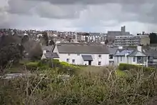 |
| Llandough Castle | Llandough | 13 May 1981 | SS9947872999 51°26′49″N 3°26′52″W |
Castle | 13408 |  | |
| The gatehouse, Llandough Castle (including attached boundary walls) | Llanfair | 16 December 1952 | SS9948972975 51°26′49″N 3°26′52″W |
Gatehouse | 13421 | 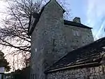 | |
| Great House with Forecourt Walls & Gatepiers | Llanblethian | 17 May 1988 | SS9888973935 51°27′19″N 3°27′24″W |
House dating from circa 1600 with a facade dated 1703, about 100m southwest of bridge over River Thaw.[11][12] | 13424 |  | |
| Barn and stable to east of Llanmithangel Place, Llanmithangel | Llandow | 19 September 1989 | SS9819171963 51°26′15″N 3°27′58″W |
Farm buildings | 13436 | | |
| Barry Dock Offices | Barry | 30 July 1990 | ST1221867659 51°24′04″N 3°15′48″W |
Prominently sited, overlooking Docks to the south, below the town on a flat site near Castleisland Point; railway immediately to rear. | 13443 | .jpg.webp) | |
| Pedestal and statue of David Davies | Barry | 30 July 1990 | ST1221267615 51°24′03″N 3°15′48″W |
Statue | Statue of engineer, industrialist and entrepreneur David Davies (1818-1890). On the seaward side of the road in front of Barry Dock Board Offices, overlooking the docks.[13][14] | 13445 |  |
| Sully Hospital | Sully | 6 November 1990 | ST1406267522 51°24′01″N 3°14′12″W |
Reached along a byroad one-and-a-half km southwest from B4267 near west outskirts of Sully. The hospital is sited in extensive, wooded grounds at Hayes Point overlooking the Bristol Channel. | 13447 | 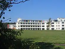 | |
| Dyffryn House | St Nicholas and Bonvilston | 15 September 1992 | ST0953372415 51°26′37″N 3°18′11″W |
Set within the large public grounds of Dyffryn Gardens; 2km to south of St Nicholas. | 13469 | 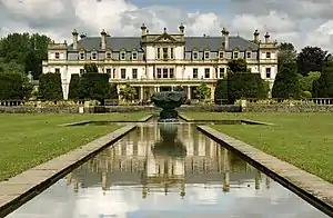 | |
| Garnllywd Farmhouse, Lannfythin | Llancarfan | 14 February 1952 | ST0572771280 51°25′58″N 3°21′27″W |
Farmhouse | 13592 | | |
| Treguff Farmhouse, Treguff | Llancarfan | 14 February 1952 | ST0308571113 51°25′51″N 3°23′44″W |
Farmhouse | 13593 | | |
| Trewallter Fawr Farmhouse | Walterston | 28 January 1963 | ST0688571129 51°25′53″N 3°20′27″W |
Farmhouse | Set on the east side of the Walterston hamlet to the northeast of the Llancarfan village. | 13606 |  |
| St Illtyd's parish church, Llantrithyd | Llantrithyd | 28 January 1963 | ST0438572792 51°26′46″N 3°22′38″W |
Church | 13609 |  | |
| Church of St Cadoc, Pendoylan | Pendoylan | 28 January 1963 | ST0598876685 51°28′53″N 3°21′19″W |
Church | 13613 |  | |
| The Blue Anchor Inn | Rhoose | 28 January 1963 | ST0350466686 51°23′28″N 3°23′18″W |
Restaurant | In the centre of East Aberthaw village on the east side of the road. | 13614 |  |
| Church of St Mary, Rhoose | Rhoose | 28 January 1963 | ST0584868847 51°24′39″N 3°21′19″W |
Church | In the centre of Penmark village on the north side of the road to Barry. | 13617 |  |
| Church of St Peter, Peterston Super Ely | Peterston Super Ely | 28 January 1963 | ST0826376406 51°28′45″N 3°19′21″W |
Church | In the village centre set within a large walled rectangular churchyard with entrances at SE and SW. | 13618 | 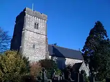 |
| Church of St Curig, Rhoose | Porthkerry | 28 January 1963 | ST0823566612 51°23′28″N 3°19′13″W |
Church | On the eastern boundary of the community set to the south-east of Porthkerry village green. | 13619 |  |
| Church of St Andrew | St Andrews Major (Dinas Powys) | 28 January 1963 | ST1385571467 51°26′08″N 3°14′26″W |
Church | On low-lying ground in the centre of the rural hamlet (northwest of the urban development of Dinas Powys) standing in a roughly rectangular churchyard with retaining wall incorporating stone stiles.[15][16] | 13625 | .jpg.webp) |
| The Old Rectory | St Andrews Major (Dinas Powys) | 28 January 1963 | ST1385971419 51°26′07″N 3°14′26″W |
(ex)House | Ex priest's house probably dating back to the 15th century, now used as a garage. Situated southwest of the church, within the grounds of The Rectory and reached by a drive through that property.[17][18] | 13626 |  |
| Church of St George, St Georges Super Ely | St Georges Super Ely | 28 January 1963 | ST1045776649 51°28′54″N 3°17′27″W |
Church | A little to the E of the hamlet of St Georges which developed round Castle Farm, main approach from N, the centre of a small cluster of buildings grouped round the churchyard, close to the Ely River. | 13633 |  |
| Church of St Bleiddian | Wenvoe | 28 January 1963 | ST1102972921 51°26′54″N 3°16′54″W |
Church | In the centre of St Lythans hamlet, set back from the road, reached by a short track and surrounded by a roughly circular walled churchyard incorporating stone stiles. | 13635 | _-_geograph.org.uk_-_1410148.jpg.webp) |
| Parish church of St Nicholas, St Nicholas | St Nicholas | 28 January 1963 | ST0901874367 51°27′39″N 3°18′40″W |
Church | 13636 | 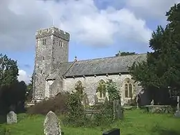 | |
| Church of St Mary, Wenvoe | Wenvoe | 28 January 1963 | ST1219672690 51°26′47″N 3°15′53″W |
Church | In the centre of Wenvoe village, fronting the main thoroughfare, in a roughly rectangular churchyard entered through a stone arch at NE. | 13643 |  |
| Coach-house and stables at Coedarhydyglyn | St Georges Super Ely | 13 September 1994 | ST1049075173 51°28′06″N 3°17′24″W |
To the NE of the main house, on the same plateau. | 14865 | | |
| Sliding Bridge at N entrance to Basin | Barry | 13 February 1996 | ST1224167139 51°23′47″N 3°15′46″W |
Bridge | Spans N entrance to Dock Basin. | 16562 |  |
| Ewenny Priory Barn | Ewenny | 3 March 1998 | SS9117077815 51°29′20″N 3°34′08″W |
Barn | Forming part of the north boundary of Ewenny Priory house courtyard, backing onto Abbey Road, just south of Ewenny River and west of the Priory.[19][20] | 19463 |  |
| East Precinct Wall at Ewenny Priory (house) | Ewenny | 3 March 1998 | SS9128977804 51°29′19″N 3°34′02″W |
Aligned roughly north/south in Ewenny Priory (house) garden, joining churchyard at southest and former southeast gatehouse. | 19465 | | |
| Former Southeast Tower at Ewenny Priory (house) | Ewenny | 3 March 1998 | SS9130777755 51°29′18″N 3°34′01″W |
At the southeast corner of Ewenny Priory (house) lawned garden adjacent to the haha forming the south boundary. | 19467 | | |
| Medieval fishpool in west part of Ewenny Priory (house) gardens | Ewenny | 3 March 1998 | SS9114177725 51°29′17″N 3°34′09″W |
Fishpond | Circular fishpond in the walled garden in the west part of the Priory complex.[21][22] | 19469 | |
| Ty Maen | St Brides Major | 3 March 1999 | SS8938777066 51°28′54″N 3°35′40″W |
House | Located off the S side of the B4524 road which leads from Bridgend to Ogmore-by-Sea. The house is just W of the community boundary with Ewenny, and is cut into the hillside with sharp drops to the N and E. | 21775 | |
| Old Leckwith Bridge | Canton / Michaelston | 2 December 1952 | ST1591975226 51°28′11″N 3°12′43″W |
Bridge | At the S end of Canton crossing the River Ely into Leckwith; at the foot of Leckwith Woods and adjacent to the later bridge carrying the B4267 | 26487 | 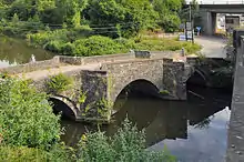 |
| Walls, Gatepiers and Gates of Llanmaes House | Llan Maes | 21 July 2003 | SS9810869481 51°24′55″N 3°28′00″W |
Walls and Gates | Surrounding the front and rear gardens of Llanmaes House. | 81305 | |
| Church of St Michael the Archangel, St Athan | Flemingston, St Athan | 9 March 2004 | ST0169270068 51°25′16″N 3°24′55″W |
Church | In the centre of Flemingston village. | 83115 | 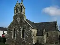 |
| Church Farmhouse (aka Glebe Farm) | Rhoose | 30 September 2004 | ST0817966682 51°23′30″N 3°19′16″W |
Farmhouse | On the north side of the Porthkerry village green about 50m from the Church of St Curig | 83147 |  |
| Outbuilding to north of Church Farmhouse | Rhoose | 30 September 2004 | ST0817466700 51°23′31″N 3°19′16″W |
Farm building | In the garden on the north side of Church Farmhouse. | 83157 | |
| Watchtower at Fonmon Castle | Rhoose | 14 February 1952 | ST0477867952 51°24′09″N 3°22′13″W |
Watchtower | About 200m south of Fonmon Castle. | 83166 | 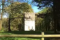 |
Notes
- Sometimes known as OSGB36, the grid reference is based on the British national grid reference system used by the Ordnance Survey.
See also
References
- "Buildings & Conservation Areas". Cadw. Retrieved 18 June 2013.
- "Planning (Listed Buildings and Conservation Areas) Act 1990". The National Archives. Retrieved 18 June 2013.
- Cadw. "Barry Castle (13180)". National Historic Assets of Wales. Retrieved 9 April 2019.
- "Barry Castle". British Listed Buildings. Retrieved 9 April 2019.
- Cadw. "The Great House (13221)". National Historic Assets of Wales. Retrieved 9 April 2019.
- "The Great House". British Listed Buildings. Retrieved 9 April 2019.
- Cadw. "St Peter's Church (13370)". National Historic Assets of Wales. Retrieved 9 April 2019.
- "St Peter's Church". British Listed Buildings. Retrieved 9 April 2019.
- Cadw. "Whitehouse Cottage (13400)". National Historic Assets of Wales. Retrieved 9 April 2019.
- "Whitehouse Cottage". British Listed Buildings. Retrieved 9 April 2019.
- Cadw. "Great House with Forecourt Walls & Gatepiers (13424)". National Historic Assets of Wales. Retrieved 9 April 2019.
- "Great House with Forecourt Walls & Gatepiers". British Listed Buildings. Retrieved 9 April 2019.
- Cadw. "Pedestal and Statue of David Davies (13445)". National Historic Assets of Wales. Retrieved 9 April 2019.
- "Pedestal and Statue of David Davies". British Listed Buildings. Retrieved 9 April 2019.
- Cadw. "Church of St Andrew (13625)". National Historic Assets of Wales. Retrieved 9 April 2019.
- "Church of St Andrew". British Listed Buildings. Retrieved 9 April 2019.
- Cadw. "The Old Rectory (13626)". National Historic Assets of Wales. Retrieved 9 April 2019.
- "The Old Rectory". British Listed Buildings. Retrieved 9 April 2019.
- Cadw. "Ewenny Priory Barn (19463)". National Historic Assets of Wales. Retrieved 9 April 2019.
- "Ewenny Priory Barn". British Listed Buildings. Retrieved 9 April 2019.
- Cadw. "Medieval fishpool in W part of Ewenny Priory (house) gardens (19469)". National Historic Assets of Wales. Retrieved 9 April 2019.
- "Medieval fishpool in W part of Ewenny Priory (house) gardens". British Listed Buildings. Retrieved 9 April 2019.
External links
![]() Media related to Grade II* listed buildings in the Vale of Glamorgan at Wikimedia Commons
Media related to Grade II* listed buildings in the Vale of Glamorgan at Wikimedia Commons
This article is issued from Wikipedia. The text is licensed under Creative Commons - Attribution - Sharealike. Additional terms may apply for the media files.