Grade II* listed buildings in Torfaen
In the United Kingdom, the term listed building refers to a building or other structure officially designated as being of special architectural, historical, or cultural significance; Grade II* structures are those considered to be "particularly important buildings of more than special interest".[1] Listing was begun by a provision in the Town and Country Planning Act 1947. Once listed, strict limitations are imposed on the modifications allowed to a building's structure or fittings. In Wales, the authority for listing under the Planning (Listed Buildings and Conservation Areas) Act 1990[2] rests with Cadw.
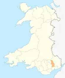
Torfaen shown within Wales
Buildings
| Name | Location | Date Listed | Grid Ref.[note 1] Geo-coordinates |
Function | Notes | Reference Number | Image |
|---|---|---|---|---|---|---|---|
| Church of Saint Peter, Henllys | Henllys | 3 January 1963 | ST2677191038 51°36′48″N 3°03′32″W |
Church | Situated in a rural location some 2.8km south of the old village at Henllys.[3][4] | 2915 | 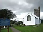 |
| The Shell Grotto, Pontypool Park | Trevethin | 7 February 1962 | SO2933401028 51°42′13″N 3°01′26″W |
Grotto | At the summit of the hill in the north east corner of Pontypool Park.[5][6] | 3112 | 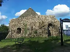 |
| Church of St Michael and All Angels | New Inn | 7 February 1962 | SO3013301101 51°42′16″N 3°00′45″W |
Church | Situated at the bottom of the 'Pitch' next to the Horse & Jockey public house.[7][8] | 3114 | 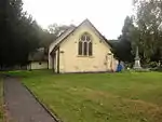 |
| Crane Street Baptist Church | Pontymoile | 7 February 1962 | SO2810400928 51°42′09″N 3°02′30″W |
Church | In Pontypool town centre backing onto Pontypool Market.[9][10] | 3118 | 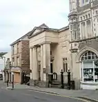 |
| Pontypool Museum | Pontymoile | 7 February 1962 | SO2826701058 51°42′13″N 3°02′22″W |
Museum | To the north of Pontypool town centre and immediately to the west of Pontypool Park house, now St Alban's RC School.[11][12] | 3120 | 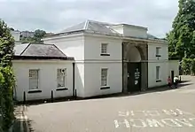 |
| St Michael's Church, Llantarnam | Llantarnam | 5 January 1951 | ST3069793155 51°37′59″N 3°00′10″W |
Church | In a churchyard on the SE side of Newport Road some 140m SW of its junction with Llantarnam Road.[13][14] | 3121 | 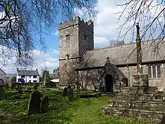 |
| Pentre-Bach and attached outbuildings | Llantarnam | 6 June 1962 | ST2855492075 51°37′23″N 3°02′00″W |
Farmhouse | Reached via a track N off Pentre Lane on the W side of Llantarnam.[15][16] | 3126 | 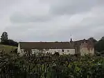 |
| Llanyrafon | Llanyrafon | 3 April 1952 | ST3032894587 51°38′45″N 3°00′30″W |
Farmhouse | 17th century gentry house.[17][18] | 3140 |  |
| Church of All Saints, Ponthir | Ponthir | 22 January 1981 | ST3203793628 51°38′14″N 2°59′00″W |
Church | In a rural location on the NE side of Llanfrechfa some 300m E of the junction of Church Road and the B4236.[19][20] | 3142 |  |
| Former St Peter's School, Blaenavon (now the Blaenavon World Heritage Centre) | Blaenavon | 4 July 1989 | SO2506408825 51°46′23″N 3°05′15″W |
School | Situated half way up Church Road immediately downhill from the other St Peter's school buildings and with south-east front facing the churchyard. Below the level of the road and set back behind iron railings on dwarf walls.[21][22] | 3150 |  |
| Former British Ironworks office and foundry quadrangle | Abersychan | 13 September 1994 | SO2572203624 51°43′35″N 3°04′37″W |
Office | The most prominent building in the area of the former British Ironworks, about 1000m south west of St Thomas's Church, Talywain.[23][24] | 14870 |  |
| St Peter's Church, Blaenavon | Blaenavon | 2 September 1995 | SO2512408778 51°46′22″N 3°05′12″W |
Church | Situated at the bottom of Church Road, on the south side, set back behind railings.[25] | 15273 | 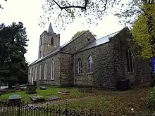 |
| Pit head building, headframe and tram circuit, Big Pit National Coal Museum | Blaenavon | 2 September 1995 | SO2389108762 51°46′20″N 3°06′16″W |
Pit Head | Situated at the north-east edge of the site.[26][27] | 15280 | 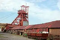 |
| Miners' baths and canteen, Big Pit National Coal Museum | Blaenavon | 2 September 1995 | SO2372008733 51°46′19″N 3°06′25″W |
Mine Baths | Situated at the top of the site to the south-west.[28][29] | 15290 |  |
| Entrance Gates to Pontypool Park | Trevethin | 29 May 1997 | SO2905900518 51°41′56″N 3°01′40″W |
Gates | The entrance on to the main drive from Pontymoel at the very south east extremity of Pontypool Park, at a bend in the road.[30][31] | 18466 | 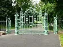 |
| 1 Forge Row | Abersychan | 5 September 1973 | SO2703906558 51°45′11″N 3°03′30″W |
Cottage | Situated at the base of a steep hillside, on the east bank of Afon Lwyd about 40m south of Cwmavon House. Rubble forecourt wall.[32][33] | 3133 | 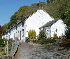 |
| 2 Forge Row | Abersychan | 5 September 1973 | SO2704006547 51°45′10″N 3°03′30″W |
Cottage | Situated at the base of a steep hillside, on the east bank of Afon Lwyd about 40m south of Cwmavon House. Rubble forecourt wall.[34] | 18586 | |
| 3 Forge Row | Abersychan | 5 September 1973 | SO2704106538 51°45′10″N 3°03′30″W |
Cottage | Situated at the base of a steep hillside, on the east bank of Afon Lwyd about 40m south of Cwmavon House. Rubble forecourt wall.[35] | 18587 | |
| 4 Forge Row | Abersychan | 5 September 1973 | SO2704206529 51°45′10″N 3°03′30″W |
Cottage | Situated at the base of a steep hillside, on the east bank of Afon Lwyd about 40m south of Cwmavon House. Rubble forecourt wall.[36] | 18588 | |
| 5 Forge Row | Abersychan | 5 September 1973 | SO2704206520 51°45′09″N 3°03′30″W |
Cottage | Situated at the base of a steep hillside, on the east bank of Afon Lwyd about 40m south of Cwmavon House. Rubble forecourt wall.[37] | 18589 | |
| 6 Forge Row | Abersychan | 5 September 1973 | SO2704306510 51°45′09″N 3°03′30″W |
Cottage | Situated at the base of a steep hillside, on the east bank of Afon Lwyd about 40m south of Cwmavon House. Rubble forecourt wall.[38] | 18590 | |
| Llantarnam Abbey | Llantarnam | 6 June 1962 | ST3115192913 51°37′51″N 2°59′46″W |
Country House | In extensive grounds on the E side of Llantarnam. Approached along a drive E from Newport Road under the Cwmbran By-pass.[39][40] | 85246 | .jpg.webp) |
| Former Nylon Spinners Factory | New Inn | 17 October 2005 | SO3084902365 51°42′57″N 3°00′08″W |
Factory | A prominent landscape feature, at the south end of the Mamhilad Park Industrial Estate.[41][42] | 85438 | 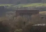 |
Notes
- Sometimes known as OSGB36, the grid reference is based on the British national grid reference system used by the Ordnance Survey.
See also
References
- "Buildings & Conservation Areas". Cadw. Retrieved 18 June 2013.
- "Planning (Listed Buildings and Conservation Areas) Act 1990". The National Archives. Retrieved 18 June 2013.
- Cadw. "Church of Saint Peter (2915)". National Historic Assets of Wales. Retrieved 10 April 2019.
- "Church of Saint Peter". British Listed Buildings.
- Cadw. "Shell Grotto (3112)". National Historic Assets of Wales. Retrieved 10 April 2019.
- "Shell Grotto". British Listed Buildings.
- Cadw. "Church of St Michael and All Angels (3114)". National Historic Assets of Wales. Retrieved 10 April 2019.
- "Church of St Michael and All Angels". British Listed Buildings.
- Cadw. "Crane Street Baptist Church (3118)". National Historic Assets of Wales. Retrieved 10 April 2019.
- "Crane Street Baptist Church". British Listed Buildings.
- Cadw. "The Valley Inheritance Museum (3120)". National Historic Assets of Wales. Retrieved 10 April 2019.
- "The Valley Inheritance Museum". British Listed Buildings.
- Cadw. "Church of St Michael and All Angels (3121)". National Historic Assets of Wales. Retrieved 10 April 2019.
- "Church of St Michael and All Angels". British Listed Buildings.
- Cadw. "Pentre-Bach and attached outbuildings (3126)". National Historic Assets of Wales. Retrieved 10 April 2019.
- "Pentre-Bach and attached outbuildings". British Listed Buildings.
- Cadw. "Llanyrafon (3140)". National Historic Assets of Wales. Retrieved 10 April 2019.
- "Llanyrafon". British Listed Buildings.
- Cadw. "Church of All Saints (3142)". National Historic Assets of Wales. Retrieved 10 April 2019.
- "Church of All Saints". British Listed Buildings.
- Cadw. "Former St Peter's School (Original School) (3150)". National Historic Assets of Wales. Retrieved 10 April 2019.
- "Former St Peter's School (Original School)". British Listed Buildings.
- Cadw. "Former British Ironworks office and foundry quadrangle (14870)". National Historic Assets of Wales. Retrieved 10 April 2019.
- "Former British Ironworks office and foundry quadrangle". British Listed Buildings.
- Cadw. "St Peter's Church (15273)". National Historic Assets of Wales. Retrieved 10 April 2019.
- Cadw. "Pit Head Building, Headframe and Tram Circuit (15280)". National Historic Assets of Wales. Retrieved 10 April 2019.
- "Pit Head Building, Headframe and Tram Circuit". British Listed Buildings.
- Cadw. "Miner's Baths and Canteen (15290)". National Historic Assets of Wales. Retrieved 10 April 2019.
- "Miner's Baths and Canteen". British Listed Buildings.
- Cadw. "Entrance Gates to Pontypool Park (18466)". National Historic Assets of Wales. Retrieved 10 April 2019.
- "Entrance Gates to Pontypool Park". British Listed Buildings.
- Cadw. "1 Forge Row (3133)". National Historic Assets of Wales. Retrieved 10 April 2019.
- "1 Forge Row". British Listed Buildings.
- Cadw. "2 Forge Row (18586)". National Historic Assets of Wales. Retrieved 10 April 2019.
- Cadw. "3 Forge Row (18587)". National Historic Assets of Wales. Retrieved 10 April 2019.
- Cadw. "4 Forge Row (18588)". National Historic Assets of Wales. Retrieved 10 April 2019.
- Cadw. "5 Forge Row (18589)". National Historic Assets of Wales. Retrieved 10 April 2019.
- Cadw. "6 Forge Row (18590)". National Historic Assets of Wales. Retrieved 10 April 2019.
- Cadw. "Llantarnam Abbey (85246)". National Historic Assets of Wales. Retrieved 10 April 2019.
- "Llantarnam Abbey". British Listed Buildings.
- Cadw. "Former Nylon Spinners Factory (85438)". National Historic Assets of Wales. Retrieved 10 April 2019.
- "Former Nylon Spinners Factory". British Listed Buildings.
External links
![]() Media related to Grade II* listed buildings in Torfaen at Wikimedia Commons
Media related to Grade II* listed buildings in Torfaen at Wikimedia Commons
| Principal settlements | | |
|---|---|---|
| Electoral wards | ||
| Communities | ||
| Places of interest | ||
| Rivers and canals | ||
| Topics | ||
This article is issued from Wikipedia. The text is licensed under Creative Commons - Attribution - Sharealike. Additional terms may apply for the media files.