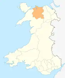
Grade II* listed buildings in Conwy County Borough
In the United Kingdom, the term listed building refers to a building or other structure officially designated as being of special architectural, historical, or cultural significance; Grade II* structures are those considered to be "particularly important buildings of more than special interest".[1] Listing was begun by a provision in the Town and Country Planning Act 1947. Once listed, strict limitations are imposed on the modifications allowed to a building's structure or fittings. In Wales, the authority for listing under the Planning (Listed Buildings and Conservation Areas) Act 1990[2] rests with Cadw.
Buildings
| Name | Location | Date Listed | Grid Ref.[note 1] Geo-coordinates |
Function | Notes | Reference Number | Image |
|---|---|---|---|---|---|---|---|
| Plas-yn-Llan (also known as Plas and Plas Llan) | Eglwysbach | 31 January 1952 | SH8017270124 53°12′53″N 3°47′45″W |
Located at the SW extremity of the village approximately 250m SE of the village school, and set with its rear against the slope of a hill; accessed via an unmetalled farm track. | 64 |  | |
| The Pin Mill | Bodnant Garden, Eglwysbach | 31 January 1952 | SH7987372248 53°14′01″N 3°48′04″W |
Pin mill | Located to the W of the house at the southern end of the Canal Terrace. | 65 | 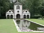 |
| Llaethwryd | Cerrigydrudion | 23 June 1967 | SH9404747916 53°01′05″N 3°34′51″W |
Farmhouse | The large farm is located S of the Holyhead Road, between the Cwm-penanner road and the minor road running S, and approximately 1400m SW of the village centre. | 72 | |
| Church of St Ddoged | Llanddoged, Llanddoged and Maenan | 23 June 1967 | SH8059263703 53°09′25″N 3°47′14″W |
Church | Prominently sited in the centre of the village within a raised, circular churchyard with rubble revettment walls. | 91 | 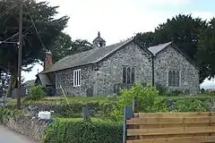 |
| Church of St Michael | Llanfihangel Glyn Myfyr | 23 June 1967 | SH9896749423 53°01′57″N 3°30′29″W |
Church | The church stands in a modified oval churchyard, approximately 250m W of Llanfihangel Bridge on the road up the Afon Alwen valley. | 92 | 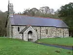 |
| Bodtegir Old Farmhouse | Llanfihangel Glyn Myfyr | 23 June 1967 | SJ0061448299 53°01′22″N 3°28′59″W |
Farmhouse | Bodtegir is a large farm SE of Llanfihangel, reached by a farm road across open ground from the minor road above the Alwen valley leading to Maerdy and Bettws Gwerful-goch. The old house lies at an angle close to the N side of the present house. | 95 | |
| Church of St Digain | Llangernyw | 23 June 1967 | SH8751067445 53°11′32″N 3°41′07″W |
Church | The parish church stands S of the centre of a roughly oval-shaped churchyard on the S side of Llangernyw village centre. The churchyard is entered through a lychgate at W. | 97 | 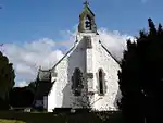 |
| Plas Tirion | Bro Garmon | 23 June 1967 | SH8104959165 53°06′59″N 3°46′43″W |
House | Prominently and imposingly sited, raised up slightly above the main Llanrwst-Betws-y-Coed road, and set back from it; accessed via a farm track running E from the road and sited across a hillslope. | 109 | |
| Hendre Wen | Bro Garmon | 23 June 1967 | SH8067258817 53°06′47″N 3°47′03″W |
Farmhouse | Set back from the main Llanrwst to Betws-y-Coed road at the western border of the community and accessed via its own farm track running W from the road; facing a farmyard to the S, behind low rubble forecourt walls. | 110 | |
| Cilcennus | Bro Garmon | 23 June 1967 | SH8091258310 53°06′31″N 3°46′50″W |
House | Set back from the main road in a prominent raised position on a hill slope; accessed from a lane running SE from the A470 to Capel Garmon. | 112 | |
| Cyffdy Hall (including attached Coach House) | Melin-y-Coed, Bro Garmon | 23 June 1967 | SH8164760138 53°07′31″N 3°46′13″W |
House | Prominently located on a hillside overlooking the Afon Cyffdy to the E, in its own parkland approximately 1km SE of Melin-y-Coed; accessed via a farm track running SW from the lane running from Melin-y-Coed towards Nebo. | 123 | |
| Soflen Farmhouse | Bro Garmon | 29 March 1974 | SH8256557196 53°05′56″N 3°45′19″W |
Farmhouse | Located approximately 1.3km NW of Nebo, immediately E of an unclassified lane running NW from Nebo to join the A470. | 140 | |
| Parish Church of St Cynfran | Llysfaen | 21 June 1950 | SH8932577489 53°16′58″N 3°39′41″W |
Church | Prominently sited in the centre of Llysfaen village at the main cross-roads; located on a commanding site within a circular, rubble-walled graveyard. | 142 | 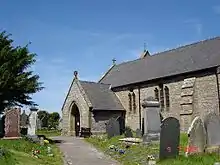 |
| St Trillo's Church | Rhos-on-Sea | 21 June 1950 | SH8321280639 53°18′35″N 3°45′15″W |
Church | Prominently sited surmounting a mound, in a large grave-yard. | 143 | 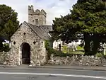 |
| Dinorben Hall | Abergele | 6 October 1952 | SH9688274872 53°15′39″N 3°32′50″W |
The farmhouse stands on high land, approximately 150m W of the minor road running S from the village of St George. | 149 | | |
| Faerdre | Llanfair Talhaiarn | 10 June 1952 | SH9626375442 53°15′57″N 3°33′25″W |
Located on a rise at the NE boundary of the community, approximately 1km SW of the village of St George; accessed via a farm track running NW from Faerdre Hill lane and set behind low rubble enclosing walls. | 150 | | |
| Garthewin | Llanfair Talhaiarn | 10 June 1952 | SH9151270480 53°13′13″N 3°37′35″W |
Strikingly located within an elevated parkland setting overlooking the Elwy valley 2km W of Llanfair Talhaiarn; accessed via a long metalled drive running NW from the main road. | 158 |  | |
| Plas Uchaf | Llannefydd | 6 October 1952 | SH9669471606 53°13′53″N 3°32′57″W |
Strikingly-located to the W of, and in the shadow of, the Mynydd y Gaer, approximately 1.5km NW of Llannefydd village; accessed via a farm track running NW from the Llanfair to Llannefydd road, immediately W of the reservoir. | 162 | | |
| Berain | Llannefydd | 6 October 1952 | SJ0072669728 53°12′55″N 3°29′17″W |
At the foot of a low hill near the cross-roads of the lanes leading from Bont Newydd and Henllan to Llannefydd village; set partly behind low rubble forecourt walls with a partly rock-cut and partly cobbled open courtyard in front. | 163 | | |
| Peniarth Fawr | Betws yn Rhos | 30 January 1968 | SH9104574261 53°15′15″N 3°38′05″W |
Located 0.5km NE of Betws-yn-Rhos village to the NW of an unclassified lane running NE from Betws towards Abergele; accessed via a farm track and set back slightly behind low rubble forecourt walls. | 170 | | |
| Coed Coch | Betws yn Rhos | 30 January 1968 | SH8812773970 53°15′03″N 3°40′42″W |
Located in its own parkland setting approximately 0.7km SW of Dolwen; accessed via a long metalled drive running SW from the road. | 172 | 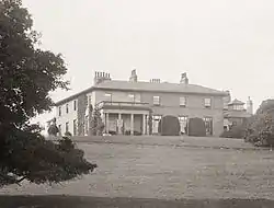 | |
| Parish Church of St Elian | Llanelian-yn-Rhos, Betws yn Rhos | 30 January 1968 | SH8635676428 53°16′22″N 3°42′20″W |
Church | Situated within a raised rubble-walled churchyard on a commanding site in the village centre, with views of the sea to the N. | 177 | 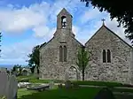 |
| Llan Farm | Betws yn Rhos | 30 January 1968 | SH8635676346 53°16′19″N 3°42′20″W |
Farmhouse | Located in the centre of the village at the main cross-roads with its gable at right-angles to the road; facing a small forecourt with part-enclosing whitened rubble walls. | 178 | |
| Plas Llanelian (also known as Plas Ucha) | Betws yn Rhos | 30 January 1968 | SH8785875510 53°15′53″N 3°40′58″W |
Located approximately 2km SE of Llanelian-yn-Rhos just beyond Llanelian school, at the end of a narrow lane. | 181 | | |
| Parish Church of St Mary | Llanfair Talhaiarn | 30 January 1968 | SH9270870135 53°13′03″N 3°36′30″W |
Church | Located on an elevated site high above the village centre within a rubble-walled churchyard. | 182 | 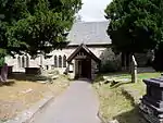 |
| C-shaped Agricultural Complex at Garthewin | Llanfair Talhaiarn | 30 January 1968 | SH9145770543 53°13′15″N 3°37′38″W |
Farm buildings | Located to the rear (NW) of Garthewin and enclosing cobbled estate yard on 3 sides. | 185 | |
| Plas Newydd | Llanfair Talhaiarn | 30 January 1968 | SH9268771530 53°13′48″N 3°36′33″W |
Located on an elevated site approximately 1.5km N of Llanfair village; immediately E of an unclassified lane running N beyond Llanfair from the A 548. | 188 | | |
| Former Stable and Coach-house Range at Melai | Llanfair Talhaiarn | 30 January 1968 | SH9012367740 53°11′43″N 3°38′46″W |
Stable | Located immediately SE of Melai, facing the house; a cobbled pavement lies in front. | 191 | |
| Church of St Sannan | Llansannan | 30 January 1968 | SH9340765900 53°10′46″N 3°35′47″W |
Church | Within an irregularly shaped churchyard, set back from the N side of the A544 in the centre of the village of Llansannan. | 212 | 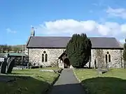 |
| Plas Isaf | Llansannan | 30 January 1968 | SH9582567563 53°11′42″N 3°33′39″W |
Set back slightly from the SE side of the B5382 at the NE end of the small hamlet of Bryn Rhydyrarian. | 213 | | |
| Plas Uchaf | Llansanffraid Glan Conwy | 30 January 1968 | SH8182575162 53°15′37″N 3°46′23″W |
Located approximately 2.5km SE of Llansanffraid Glan Conwy overlooking the estuary on an elevated W-facing site; accessed via a farm track leading S from the B 5381. | 220 | | |
| Tan-yr-Ogof Lodge including adjoining walls and towers to S, E and W | Llanddulas and Rhyd-y-Foel | 27 October 1950 | SH9161178052 53°17′18″N 3°37′39″W |
Prominently located on the roadside, some 60m E of the junction with Rhyd-y-Foel Road. | 232 | | |
| King's Lodge, also known as Abergele Lodge | Abergele | 27 October 1950 | SH9394077555 53°17′04″N 3°35′32″W |
Located at the W end of the town, at the junction of a lane to Tan-y-Gopa and Betws-yn-Rhos. | 233 | | |
| Church of St Michael | Abergele | 27 October 1950 | SH9454577645 53°17′07″N 3°35′00″W |
Church | Located in a rectangular churchyard in the angle between Water Street and Market Street, at the centre of the town, and accessed by the short Church Street off Market Street | 237 | 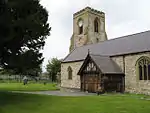 |
| Morfa Lodge | Abergele | 10 April 1973 | SH9836577424 53°17′03″N 3°31′33″W |
Lodge | This outer lodge to Kinmel Park is set at the angle of the Rhuddlan Road and the wooded avenue, Coed-y-drive, running N from the Golden Lodge. | 240 | |
| Plas Kinmel | Abergele | 10 April 1973 | SH9802776547 53°16′34″N 3°31′51″W |
Plas Kinmel is located on level ground on the E, at the bottom of Primrose Hill, St George. | 243 | | |
| Church of St Mary, with churchyard walls | Kinmel Bay and Towyn | 10 April 1973 | SH9734279428 53°18′07″N 3°32′31″W |
Church | The church lies immediately E of the Sandbank Road crossroads at the centre of Towyn, enclosed by a rectangular churchyard. | 250 | 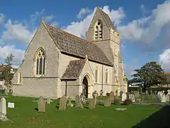 |
| Tŷ'n Llan Nursing Home | Kinmel Bay and Towyn | 10 April 1973 | SH9734779460 53°18′08″N 3°32′31″W |
Nursing Home | Located immediately N of the Church of St Mary, with which it is linked. | 251 |  |
| Towyn and Kinmel Bay Youth Club | Kinmel Bay and Towyn | 10 April 1973 | SH9739879456 53°18′08″N 3°32′28″W |
Youth club | One of a group of 3 buildings, set facing the main Rhyl to Abergele Road, immediately E of Sandbank Road at the centre of Towyn. | 252 | |
| Gatehouse at Gilar, with attached courtyard walls | Pentrefoelas | 23 June 1967 | SH8839349911 53°02′05″N 3°39′57″W |
Gatehouse | Gilar lies to the S of Rhydlydan, approached by a farm road. The gatehouse is on the N side of the front walled court, with an axial path leading directly to the porch of the E house. | 263 | |
| Gilar | Pentrefoelas | 31 January 1952 | SH8839349868 53°02′04″N 3°39′57″W |
The group of buildings at Gilar lies apart, to the S of the hamlet of Rhydlydan, and is reached by a minor farm road. | 264 | | |
| Pont Ysbyty Ifan | Ysbyty Ifan | 17 March 1953 | SH8422148818 53°01′27″N 3°43′40″W |
Bridge | Prominently located in the centre of the village and carrying the main road over the Afon Conwy. | 3158 | 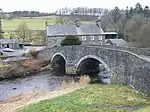 |
| Cymryd | Henryd | 17 March 1953 | SH7922875886 53°15′58″N 3°48′44″W |
Strikingly sited on low-lying land on the W bank of the Conwy estuary, at the E boundary of the community; accessed via a long track leading E from Brynseiri Road. | 3159 | | |
| Farchwel | Caerhun | 13 October 1966 | SH7662370040 53°12′47″N 3°50′56″W |
Prominently located above a bend in the main road (B5106) and set back to the W, approximately 1km SW of Caerhun; accessed via a long metalled track running W from the road. | 3173 | | |
| Llanerch-y-Felin | Caerhun | 13 October 1966 | SH7590872084 53°13′53″N 3°51′38″W |
Located off the village lane to the N facing its former farmyard, now metalled; accessed via a short metalled lane. | 3175 | | |
| Church of St Curig | Capel Curig | 13 October 1966 | SH7185257976 53°06′13″N 3°54′56″W |
Church | Situated immediately W of the A 4086 (Capel Curig to Caernarfon road), on the S bank of the Afon Llugwy; approximately 300m NE of Plas-y-Brenin (the National Recreation Centre). | 3178 | 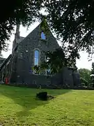 |
| Pont Gethin | Dolwyddelan | 13 October 1966 | SH7797453870 53°04′05″N 3°49′22″W |
Bridge | Spanning the Lledr valley dramatically at the western boundary of the community with that of Betws-y-Coed and spanning the A 470 Llanrwst to Dolwyddelan road; partly in Betws-y-Coed community. | 3187 | 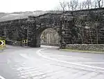 |
| Parish Church of St Peter | Caerhun | 13 October 1966 | SH7607269567 53°12′31″N 3°51′26″W |
Church | Prominently located on an elevated slope in the centre of the village, approximately 1km W of the Conwy Road (B5106); set within a circular rubble-walled churchyard. | 3203 | .jpg.webp) |
| Parish Church of St. Mary | Trefriw | 13 October 1966 | SH7807563221 53°09′08″N 3°49′29″W |
Church | Prominently sited in the town centre within a raised, rubble-walled churchyard; on sloping ground, the W end set into a hill. | 3219 | 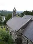 |
| St Michael's Church | Betws-y-Coed | 21 June 1950 | SH7960056560 53°05′34″N 3°47′58″W |
Church | Located on the W bank of the Afon Conwy, 100m E of Betws-y-Coed railway station. | 3229 | 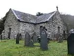 |
| Pont-y-Pair | Betws-y-Coed | 21 June 1950 | SH7916256711 53°05′38″N 3°48′22″W |
Bridge | Carrying the B5106 and fording the Afon Llugwy in the centre of the town. | 3230 | 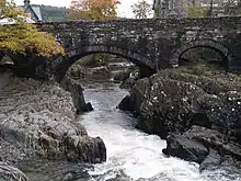 |
| Toll house at Conwy Suspension Bridge | Conwy | 10 August 1981 | SH7830077470 53°16′49″N 3°49′36″W |
Toll house | On the E side of Conwy Suspension Bridge. | 3235 | 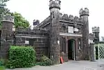 |
| 11 Castle Street | Conwy | 23 September 1950 | SH7823277604 53°16′53″N 3°49′40″W |
House | A detached building fronting the street. | 3256 | .jpg.webp) |
| Aberconwy House | Conwy | 23 September 1950 | SH7819077625 53°16′54″N 3°49′43″W |
House | On the corner of Castle Street and High Street. | 3262 | 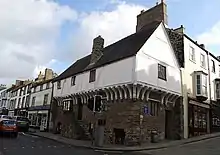 |
| Deganwy Castle | Conwy | 23 September 1950 | SH7822379438 53°17′52″N 3°49′43″W |
Castle | Set across 2 steep hills known as The Fardre inland from the village, with panoramic view across Conwy, estuary, coastline and N Wales mountains. | 3365 | 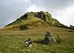 |
| The Old Cockpit | Conwy | 23 September 1950 | SH7805677575 53°16′52″N 3°49′50″W |
Set back from the street and reached by a path to the side of Alfredo Restaurant. | 3367 | 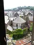 | |
| Dovecote at Gloddaeth Hall, including attached single-storey blocks | Llandudno | 16 March 1976 | SH8035580710 53°18′35″N 3°47′50″W |
Dovecote | About 100m E of Hall, to S of former stables. | 3415 | |
| Penrhyn Old Hall, including forecourt wall, steps and mounting block | Llandudno | 16 March 1976 | SH8155581535 53°19′03″N 3°46′46″W |
Restaurant | On NW side of Penrhyn Old Road, about 250m W of roundabout at bottom of Penrhyn Hill. | 3467 | 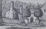 |
| Bryn-y-Neuadd Farmhouse, including attached dairy | Llanfairfechan | 14 April 1992 | SH6799174777 53°15′13″N 3°58′49″W |
At E end of grounds of Bryn-y-Neuadd Hospital, reached from Aber Road by driveway almost opposite War Memorial (SH 680 747). At SW corner of farmyard. | 3518 | | |
| Church Institute | Llanfairfechan | 14 April 1992 | SH6830874796 53°15′14″N 3°58′32″W |
Church Institute | Parallel to road opposite junction with The Close. | 3565 | |
| Wern Isaf (formerly Rose Briars) | Llanfairfechan | 31 May 1990 | SH6860675109 53°15′24″N 3°58′16″W |
Reached from Park Road along private drive uphill to NE of Llanfairfechan; sited high above Penmaenmawr Road with extensive views over Conwy Bay to Puffin Island and Anglesey. | 3567 | | |
| Tŷ Mawr | Bro Machno | 13 October 1966 | SH7697952410 53°03′17″N 3°50′13″W |
At head of Wybrnant Valley approx 2.5 km NW of Penmachno. Best reached via signposted minor road branching N off Penmachno-Glasgwm road approx 700m W of Penmachno village centre. | 3578 | 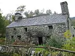 | |
| Felin Isaf Mill | Pentrefelin, Llansanffraid Glan Conwy | 22 December 1975 | SH8028274938 53°15′28″N 3°47′46″W |
Mill | Located below the A 496 on the W side at Pentrefelin; accessed via a short drive from an unclassified road leading W opposite Bont Newydd. | 3630 | |
| Grand Theatre | Llandudno | 16 March 1976 | SH7912082013 53°19′16″N 3°48′58″W |
Theatre | On corner with Irving Road. | 3633 | 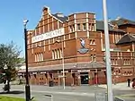 |
| Church of All Saints | Deganwy, Conwy | 24 June 1986 | SH7832979018 53°17′39″N 3°49′37″W |
Church | Set against a steep hillside behind the seafront houses near Deganwy Pier, beyond a short lane off the A546. | 3635 | 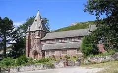 |
| St. Mary's Church | Betws-y-Coed | 21 January 1988 | SH7936656449 53°05′30″N 3°48′10″W |
Church | Located immediately to the SW of the main road (A5) in the centre of the town. | 3640 | 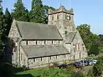 |
| Llandudno Pier, including Stone Lodge, Pier End Pavilions, Kiosks and remains of Pier Pavilion | Llandudno | 24 March 1969 | SH7835582930 53°19′45″N 3°49′41″W |
Pier | At N end of The Promenade. | 3641 | 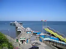 |
| Ysgubor-y-Glyn (adjacent to Capel Curig Training Camp). | Capel Curig | 10 April 1990 | SH7508957511 53°06′01″N 3°52′02″W |
Located off the main road to the S, immediately adjacent to the Capel Curig Training Camp, approximately 1km W of the Ty Hyll (Ugly House). | 3647 | | |
| Statue of Hercules and pedestal at Gloddaeth Hall | Llandudno | 16 March 1976 | SH8027280643 53°18′33″N 3°47′54″W |
Statue | Sited in garden about 50m SE of front of Hall. | 5775 | |
| Church of St Hilary | Conwy | 1 October 1951 | SH7932580321 53°18′22″N 3°48′45″W |
Church | In a large churchyard N of the main settlement. | 5776 | 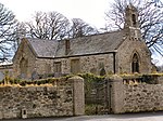 |
| Church of St Tudno | Llandudno | 1 October 1951 | SH7697383830 53°20′13″N 3°50′57″W |
Church | On NE slopes of Great Orme, in a hollow known as Pant yr Eglwys. | 5797 | 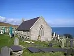 |
| Benar farmhouse, including forecourt wall and stairs | Bro Machno | 13 October 1966 | SH7942051771 53°02′58″N 3°48′01″W |
Farmhouse | On prominent hillside site above Afon Machno to NW of B4406. | 5851 | |
| Fedw Deg old farmhouse | Bro Machno | 13 October 1966 | SH7891853283 53°03′47″N 3°48′30″W |
Farmhouse | Above Lledr valley reached from forest track at SH 798 539 (near Tan-yr-allt) taking first L and then first R turnings. | 5895 | |
| Pen-y-Bryn farmhouse and attached agricultural range | Bro Machno | 13 October 1966 | SH7869450294 53°02′10″N 3°48′38″W |
Farmhouse | Above and to NW of road approx 400 metres SW of Penmachno church. House faces roughly SE behind small stone-walled front garden. | 5907 | |
| Pen-y-Bryn barn | Bro Machno | 13 October 1966 | SH7869950309 53°02′11″N 3°48′38″W |
Barn | To N of and at a right angle to farmhouse. | 5908 | |
| Coed-y-Ffynnon | Bro Machno | 13 October 1966 | SH8038153028 53°03′40″N 3°47′11″W |
Approx 300m NW of Penmachno Woollen Mill, reached via forestry tracks branching off minor road to SW of Pandy Mill at SH 806 530. | 5918 | | |
| St Paul's Church | Colwyn Bay | 25 July 1994 | SH8501878828 53°17′38″N 3°43′36″W |
Church | Occupies a block of land at the centre of the town between Woodland Road East and Rhiw Road. | 14657 | 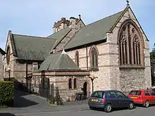 |
| Christ Church | Bryn-y-Maen, Colwyn Bay | 25 July 1994 | SH8362476150 53°16′10″N 3°44′47″W |
Church | Forms the focal point of the small hillside hamlet of Bryn y Maen, approx 3km S of the town. | 14722 | 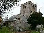 |
| Church of Saint John | Old Colwyn | 9 September 1994 | SH8694678411 53°17′26″N 3°41′51″W |
Church | On the corner of Station Road and Cliff Road. | 14863 | 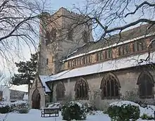 |
| Raised walk at Gwydir Castle | Trefriw | 30 May 1996 | SH7988961021 53°07′58″N 3°47′48″W |
Walkway | Listed as a mid-Tudor carved courtyard or garden arch, with associated walls. Additional NG Ref's 27970 36097 to 27988 to 36107
Group value with other listed items at Gwydir Castle. |
16938 | |
| Former Oat Kiln at Felin Isaf | Llansanffraid Glan Conwy | 1 May 1996 | SH8026074958 53°15′29″N 3°47′47″W |
Oat Kiln | Located immediately to the N of the main and clover mills at Felin Isaf. | 17042 | |
| Condover House (formerly Villa Marina) | Llandudno | 13 June 1996 | SH8060782259 53°19′26″N 3°47′38″W |
On north (sea) side of Colwyn Road, near W flank of Little Orme. | 17095 | 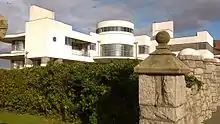 | |
| Clover Mill | Llansanffraid Glan Conwy | 22 December 1975 | SH8027374945 53°15′29″N 3°47′46″W |
Clover Mill | Located below the A 496 on the W side at Pentrefelin; accessed via a short drive from an unclassified road leading W opposite Bont Newydd. | 17320 | |
| Coach-house and Stable Range at Kinmel with terrace walls, steps and archway to E | Abergele | 10 June 1970 | SH9814074836 53°15′39″N 3°31′43″W |
Coach house | The stable range extends at right angles, at the S end of the main W elevation of Kinmel, and set above of a series of 3 retained terraces. | 18681 | |
| Entrance Screen to the main entrance front at Kinmel | Abergele | 8 May 1997 | SH9816974926 53°15′42″N 3°31′41″W |
Screen | The screen encloses the court d'honneur on the E, in front of the E entrance elevation of Kinmel. | 18693 | |
| West Range of Farm Buildings at Plas Kinmel | Abergele | 8 May 1997 | SH9799476568 53°16′35″N 3°31′52″W |
Farm building | Plas Kinmel stands at the E at the bottom of Primrose Hill, N of St George village. The West Range continues the house to the N enclosing the farmyard on the W. | 18707 | |
| North Range of Farmyard Buildings at Plas Kinmel with the enclosed muck yard and entrance gate pier | Abergele | 8 May 1997 | SH9802076598 53°16′36″N 3°31′51″W |
Farm building | Plas Kinmel stands at the E at the bottom of Primrose Hill, N of St George village. This north range lies opposite the house and completes the enclosed farmyard. | 18708 | |
| East Range of Farmyard Buildings at Plas Kinmel | Abergele | 8 May 1997 | SH9804676576 53°16′35″N 3°31′50″W |
Farm building | Plas Kinmel stands at the E at the bottom of Primrose Hill, N of St George village. The East Range encloses the large stock yard of which the house forms the SW corner. | 18709 | |
| Piggery at Plas Kinmel | Abergele | 8 May 1997 | SH9806876560 53°16′34″N 3°31′48″W |
Farm building | Plas Kinmel stands at the E at the bottom of Primrose Hill, N of St George village. The piggery lies on the E side of the E range of the farmyard, and behind the dovecote at the end of the S range. | 18710 | |
| Hendre-fawr | Abergele | 8 May 1997 | SH9634076905 53°16′44″N 3°33′22″W |
Located on fertile drained flat lands between Abergele and Rhuddlan, and accessed by a farm road, 1m E of Abergele. | 18713 | | |
| Parish Church of St Cynbryd | Llanddulas and Rhyd-y-Foel | 11 December 1997 | SH9085478211 53°17′23″N 3°38′20″W |
Church | Located in the centre of the village on the north bank of the Afon Dulas, within its own large, rubble-walled churchyard. | 19024 | 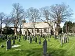 |
| Hen Wrych Lodge including adjoining crenellated boundary walls and towers | Llanddulas and Rhyd-y-Foel | 11 December 1990 | SH9280878076 53°17′20″N 3°36′34″W |
Lodge | Facing the road at the eastern boundary of the community, approximately 600m NE of Gwrych Castle | 19039 | |
| Plas Tan-yr-Ogof including adjoining walls and arches to E and W | Llanddulas and Rhyd-y-Foel | 11 December 1997 | SH9163478074 53°17′19″N 3°37′37″W |
House | Located on the roadside approximately 80m E of the junction with Rhyd-y-Foel Road. | 19040 | |
| Tan-yr-Ogof Farmhouse including adjoining arch and walls to E | Llanddulas and Rhyd-y-Foel | 11 December 1997 | SH9167878069 53°17′19″N 3°37′35″W |
Farmhouse | Located on the roadside approximately 100m E of the junction with Rhyd-y-Foel Road. | 19041 | |
| L-shaped Agricultural Range at Berain | Llannefydd | 15 May 1998 | SJ0071469767 53°12′56″N 3°29′18″W |
Farm building | Located immediately NW of Berain, partly enclosing a large farmyard. | 19855 | |
| Voelas | Pentrefoelas | 19 October 1998 | SH8498651540 53°02′55″N 3°43′02″W |
House | Voelas Estate lies on the W edge of the community, W of Pentrefoelas. The house stands in its own parkland overlooking the picturesque narrow valley of the Afon Conwy. | 20585 | |
| Old House and attached Cartshed block at Cysulog | Llangwm | 20 May 2003 | SJ0099845106 52°59′39″N 3°28′35″W |
House | Cysulog is about 1 km north of Maerdy. The Old House and Cartshed block is to the NW of the present house. | 80944 | |
Notes
- Sometimes known as OSGB36, the grid reference is based on the British national grid reference system used by the Ordnance Survey.
References
- "Buildings & Conservation Areas". Cadw. Retrieved 18 June 2013.
- "Planning (Listed Buildings and Conservation Areas) Act 1990". The National Archives. Retrieved 18 June 2013.
External links
![]() Media related to Grade II* listed buildings in Conwy County Borough at Wikimedia Commons
Media related to Grade II* listed buildings in Conwy County Borough at Wikimedia Commons