Grade II* listed buildings in Caerphilly County Borough
In the United Kingdom, the term listed building refers to a building or other structure officially designated as being of special architectural, historical, or cultural significance; Grade II* structures are those considered to be "particularly important buildings of more than special interest".[1] Listing was begun by a provision in the Town and Country Planning Act 1947. Once listed, strict limitations are imposed on the modifications allowed to a building's structure or fittings. In Wales, the authority for listing under the Planning (Listed Buildings and Conservation Areas) Act 1990[2] rests with Cadw.
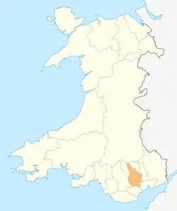
Caerphilly County Borough shown within Wales
Buildings
| Name | Location | Date Listed | Grid Ref.[note 1] Geo-coordinates |
Function | Notes | Reference Number | Image |
|---|---|---|---|---|---|---|---|
| Gelligroes Mill | Pontllanfraith | 25 May 1962 | ST1779194715 51°38′43″N 3°11′22″W |
Mill | Reached by a side road running SE from Newport Road (A4048); the Mill faces the Sirhowy River and the bridge and is within a grassy enclosure which retains sluices, channelled millrace and tail race, grinding stones and other machinery.[3][4] | 1880 |  |
| Penllwyn, former manor house now Penllwyn Arms public house | Pontllanfraith | 25 May 1962 | ST1740695592 51°39′11″N 3°11′43″W |
Inn | On the hillside W of the town centre, in an open space but surrounded by Penllwyn estate development.[5][6] | 1881 |  |
| Church of St Tudor Mynyddislwyn | Ynysddu | 25 May 1962 | ST1933593917 51°38′18″N 3°10′01″W |
Church | On the crest of Mynyddislwyn, surrounded by a walled churchyard.[7][8] | 1882 |  |
| Chimney at former Navigation Colliery | Crumlin | 27 January 1982 | ST2110798790 51°40′56″N 3°08′33″W |
Colliery chimney | In the centre of the main Revetment Wall, between the N and S Winding Engine Houses and close to the Workshops and Store, and Lamp Room to rear.[9][10] | 1890 |  |
| South Winding Engine House at former Navigation Colliery | Crumlin | 27 January 1982 | ST2114098740 51°40′55″N 3°08′31″W |
Colliery engine house | Standing on the main Revetment Wall at the S end. Paired with the North Winding Engine House at N end.[11][12] | 1891 | |
| North Winding Engine House at former Navigation Colliery | Crumlin | 27 January 1982 | ST2110598841 51°40′58″N 3°08′33″W |
Colliery engine house | Standing on the main Revetment Wall at the N end. Paired with the South Winding Engine House at S end.[13][14] | 1894 |  |
| Power House and Pump House at former Navigation Colliery | Crumlin | 27 January 1982 | ST2112098860 51°40′59″N 3°08′32″W |
Colliery power house | Located on a lane N from Kendon Road near the centre of Crumlin. At the N end of the colliery complex at road level, paired in position with the Fan House on the other side of the Heapstead.[15][16] | 1896 | |
| Fan House and Fan Drift at former Navigation Colliery | Crumlin | 27 January 1982 | ST2116098750 51°40′55″N 3°08′30″W |
Colliery fan house | Located on a lane N from Kendon Road near the centre of Crumlin. At the S end of the colliery complex at road level, paired in position with the Power House on the other side of the Heapstead.[17] | 1897 | |
| Cwmdows Farmhouse | Newbridge | 27 January 1982 | ST2048096923 51°39′56″N 3°09′04″W |
Farmhouse | Aligned N/S at right angles to the road, set on a platform in the hillside and now surrounded by C19 and later housing development.[18][19] | 1899 | |
| Church of St Luke, Abercarn | Abercarn | 3 May 1987 | ST2164095077 51°38′57″N 3°08′02″W |
Church (disused) | Set into the wooded hillside above the Ebbw Vale just above the centre of Abercarn, reached up a side road and approached through a shallow stone tiled gateway and up a steep terraced double flight of steps to W front.[20][21] | 1903 | 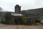 |
| Church of St Barrwg | Bedwas, Bedwas, Trethomas and Machen | 23 November 1961 | ST1710889196 51°35′44″N 3°11′53″W |
Church | Located in a high prominent position in the village at the N end of Church Street. Surrounded by a large graveyard.[22][23] | 13542 |  |
| Hengoed Viaduct | Gelligaer | 31 July 1980 | ST1542294936 51°38′49″N 3°13′26″W |
Viaduct | A prominent landscape feature spanning the Rhymney Valley between Maesycwmmer and Hengoed. Partly in Maesycwmmer Community.[24][25] | 13566 | 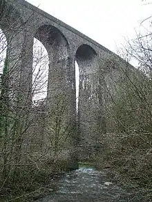 |
| The Woollen Mill, Maesycwmmer | Maesycwmmer | 31 July 1980 | ST1544494894 51°38′47″N 3°13′24″W |
Woollen Mill | Backing onto the River Rhymney beneath the Hengoed railway viaduct. Accessed from the driveway to Maesycwmmer House[26][27] | 13567 | |
| Groeswen Chapel | Groeswen, Penyrheol, Trecenydd and Energlyn | 8 April 1987 | ST1279787000 51°34′30″N 3°15′35″W |
Chapel | Set within its burial ground, the chapel faces the road with vestry adjoining to the W. Located at the E end of Groeswen village.[28][29] | 13573 |  |
| Church of St David, Rhymney | Rhymney | 7 December 1990 | SO1118208026 51°45′50″N 3°17′18″W |
Church | On the main thoroughfare a little N of the town centre, surrounded by an extensive walled churchyard sloping to S and W.[30][31] | 13578 | 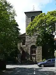 |
| Penallta Colliery Engine Hall and Fan House | Gelligaer | 11 May 1991 | ST1398095839 51°39′17″N 3°14′41″W |
Engine house | Situated between Ystrad Mynach and Gelligaer, on the east side of Penalltau Road. The Engine Hall is at the north side of the colliery complex.[32][33] | 13579 | 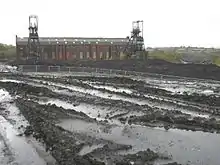 |
| Penallta Colliery Baths Building | Gelligaer | 11 May 1991 | ST1387695717 51°39′13″N 3°14′47″W |
Colliery baths | Situated between Ystrad Mynach and Gelligaer, on the east side of Penalltau Road. The Baths Building faces Penalltau Road, on the west of the complex.[34][35] | 13580 | |
| Penallta Colliery No.1 Headframe | Gelligaer | 11 May 1991 | ST1396295780 51°39′15″N 3°14′42″W |
Colliery headstock | Situated between Ystrad Mynach and Gelligaer, on the east side of Penalltau Road. The western of the two headframes, at the centre of the complex.[36][37] | 13585 | .jpg.webp) |
| Penallta Colliery No.2 Headframe | Gelligaer | 11 May 1991 | ST1401995812 51°39′16″N 3°14′39″W |
Colliery headstock | Situated between Ystrad Mynach and Gelligaer, on the east side of Penalltau Road. The eastern of the two headframes, at the east of the complex.[38][39] | 13586 | .jpg.webp) |
| Ruperra Castle | Rudry | 5 August 1964 | ST2197986311 51°34′13″N 3°07′38″W |
Castle | About 2.5km E of Rudry Church, on high ground above Rhymney valley and reached by private drive W of minor road between Michaelston-y-Fedw and Draethen.[40][41] | 14069 | 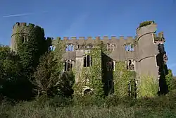 |
| Tabor United Reformed Church, Maesycwmmer | Maesycwmmer | 14 October 1997 | ST1558994743 51°38′43″N 3°13′17″W |
Church | On prominent site fronting Tabor Road with North Avenue to the rear.[42][43] | 18961 |  |
| Bryngwyn Colliery Engine House | Bedwas, Bedwas, Trethomas and Machen | 2 August 1999 | ST1620389288 51°35′46″N 3°12′40″W |
Engine House | Located in a small field on the W side of Bedwas village. The building is accessible by footpath, either from Pandy Mawr Road to the W or from Nursery Road (?) to the E. The building is heavily overgrown with vegetation.[44][45] | 21311 | |
| Hanbury Road Baptist Chapel and Schoolrooms, including gates and gatepiers | Bargoed | 3 January 1999 | ST1516899734 51°41′24″N 3°13′43″W |
Public library | Situated in the centre of Bargoed, about 150m N of the police station, set back behind small forecourt with railings.[46][47] | 21428 |  |
| Penuel Baptist Church | Rhymney | 3 January 1999 | SO1107308241 51°45′57″N 3°17′24″W |
Church | Located some 100m W of Post Office, on NW side of street, set in grassed yard with iron railings.[48][49] | 21430 |  |
| Church of Our Lady of Peace and attached Presbytery | Newbridge | 17 March 1999 | ST2106797620 51°40′19″N 3°08′34″W |
Church/Presbytery | On the N edge of Newbridge, near the border with the Crumlin Community, on the W hillside of and overlooking the Ebbw Valley. Set on a walled terrace with gate piers and terraced steps, incorporating a small shrine.[50] | 21499 |  |
| Tomb of William Edwards in the churchyard of St Ilan, Eglwysilan | Aber Valley | 28 June 1999 | ST1065288983 51°35′33″N 3°17′28″W |
Tomb | On the S side of the nave to SW of the porch, adjacent to path on the W side.[51][52] | 21957 | |
| Hengoed Viaduct | Maesycwmmer | 31 July 1980 | ST1556094920 51°38′48″N 3°13′18″W |
Viaduct | A prominent landscape feature spanning the Rhymney valley between Maesycwmmer and Hengoed.[53][54] | 22325 | |
| Elliot Colliery Winding Engine House and Engine | New Tredegar | 22 June 2001 | SO1473802720 51°43′00″N 3°14′08″W |
Colliery Engine House | Now standing on a terrace with landscaped surroundings above the E bank of Rhymney River, S of New Tredegar centre, in the area known as Elliot'sTown.[55][56] | 25495 |  |
| Church of St Sannan | Bargoed | 17 July 2001 | SO1665800309 51°41′43″N 3°12′26″W |
Church | In a large churchyard on the ridge of hill approximately 1.5km NE of Bargoed.[57][58] | 25522 | 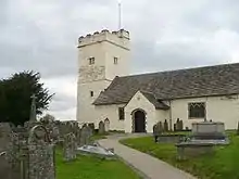 |
| Blackwood Miners Welfare Institute | Blackwood | 31 May 2002 | ST1739497425 51°40′10″N 3°11′45″W |
Miner's Welfare | At the N end of High Street approximately 240m S of the parish church.[59][60] | 26710 | 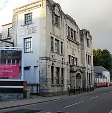 |
Notes
- Sometimes known as OSGB36, the grid reference is based on the British national grid reference system used by the Ordnance Survey.
See also
- Listed buildings in Wales
- Grade I listed buildings in Caerphilly County Borough
- List of Scheduled Monuments in Caerphilly
References
- "Buildings & Conservation Areas". Cadw. Retrieved 18 June 2013.
- "Planning (Listed Buildings and Conservation Areas) Act 1990". The National Archives. Retrieved 18 June 2013.
- Cadw. "Gelli-groes Mill (1880)". National Historic Assets of Wales. Retrieved 8 April 2019.
- "Gelli-groes Mill". British Listed Buildings. Retrieved 8 April 2019.
- Cadw. "Penllwyn, former manor house now Penllwyn Arms public house (1881)". National Historic Assets of Wales. Retrieved 8 April 2019.
- "Penllwyn, former manor house now Penllwyn Arms public house". British Listed Buildings. Retrieved 8 April 2019.
- Cadw. "Church of St Tudor Mynyddislwyn (1882)". National Historic Assets of Wales. Retrieved 8 April 2019.
- "Church of St Tudor Mynyddislwyn". British Listed Buildings. Retrieved 8 April 2019.
- Cadw. "Former Navigation Colliery Chimney (1890)". National Historic Assets of Wales. Retrieved 8 April 2019.
- "Former Navigation Colliery Chimney". British Listed Buildings. Retrieved 8 April 2019.
- Cadw. "Former Navigation Colliery South Winding Engine House (1891)". National Historic Assets of Wales. Retrieved 8 April 2019.
- "Former Navigation Colliery South Winding Engine House". British Listed Buildings. Retrieved 8 April 2019.
- Cadw. "Former Navigation Colliery North Winding Engine House (1894)". National Historic Assets of Wales. Retrieved 8 April 2019.
- "Former Navigation Colliery North Winding Engine House". British Listed Buildings. Retrieved 8 April 2019.
- Cadw. "Former Navigation Colliery Power House and Pump House (1896)". National Historic Assets of Wales. Retrieved 8 April 2019.
- "Former Navigation Colliery Power House and Pump House". British Listed Buildings. Retrieved 8 April 2019.
- Cadw. "Former Navigation Colliery Fan House and Fan Drift (1897)". National Historic Assets of Wales. Retrieved 8 April 2019.
- Cadw. "Cwmdows Farmhouse (1899)". National Historic Assets of Wales. Retrieved 8 April 2019.
- "Cwmdows Farmhouse". British Listed Buildings. Retrieved 8 April 2019.
- Cadw. "Church of St Luke (1903)". National Historic Assets of Wales. Retrieved 8 April 2019.
- "Church of St Luke". British Listed Buildings. Retrieved 8 April 2019.
- Cadw. "Church of St Barrwg (13542)". National Historic Assets of Wales. Retrieved 8 April 2019.
- "Church of St Barrwg". British Listed Buildings. Retrieved 8 April 2019.
- Cadw. "Hengoed Viaduct (partly in Maesycwmmer Community) (13566)". National Historic Assets of Wales. Retrieved 8 April 2019.
- "Hengoed Viaduct (partly in Maesycwmmer Community)". British Listed Buildings. Retrieved 8 April 2019.
- Cadw. "The Woollen Mill (13567)". National Historic Assets of Wales. Retrieved 8 April 2019.
- "The Woollen Mill". British Listed Buildings. Retrieved 8 April 2019.
- Cadw. "Groeswen Chapel (13573)". National Historic Assets of Wales. Retrieved 8 April 2019.
- "Groeswen Chapel". British Listed Buildings. Retrieved 8 April 2019.
- Cadw. "Church of St David (13578)". National Historic Assets of Wales. Retrieved 8 April 2019.
- "Church of St David". British Listed Buildings. Retrieved 8 April 2019.
- Cadw. "Penallta Colliery Engine Hall and Fan House (13579)". National Historic Assets of Wales. Retrieved 8 April 2019.
- "Penallta Colliery Engine Hall and Fan House". British Listed Buildings. Retrieved 8 April 2019.
- Cadw. "Penallta Colliery Baths Building (13580)". National Historic Assets of Wales. Retrieved 8 April 2019.
- "Penallta Colliery Baths Building". British Listed Buildings. Retrieved 8 April 2019.
- Cadw. "Penallta Colliery No.1 Headframe (13585)". National Historic Assets of Wales. Retrieved 8 April 2019.
- "Penallta Colliery No.1 Headframe". British Listed Buildings. Retrieved 8 April 2019.
- Cadw. "Penallta Colliery No.2 Headframe (13586)". National Historic Assets of Wales. Retrieved 8 April 2019.
- "Penallta Colliery No.2 Headframe". British Listed Buildings. Retrieved 8 April 2019.
- Cadw. "Ruperra Castle (14069)". National Historic Assets of Wales. Retrieved 8 April 2019.
- "Ruperra Castle". British Listed Buildings. Retrieved 8 April 2019.
- Cadw. "Tabor United Reformed Church (18961)". National Historic Assets of Wales. Retrieved 8 April 2019.
- "Tabor United Reformed Church". British Listed Buildings. Retrieved 8 April 2019.
- Cadw. "Bryngwyn Colliery Engine House (21311)". National Historic Assets of Wales. Retrieved 8 April 2019.
- "Bryngwyn Colliery Engine House". British Listed Buildings. Retrieved 8 April 2019.
- Cadw. "Hanbury Road Baptist Chapel and Schoolrooms, including gates and gatepiers (21428)". National Historic Assets of Wales. Retrieved 8 April 2019.
- "Hanbury Road Baptist Chapel and Schoolrooms, including gates and gatepiers". British Listed Buildings. Retrieved 8 April 2019.
- Cadw. "Penuel Baptist Church (21430)". National Historic Assets of Wales. Retrieved 8 April 2019.
- "Penuel Baptist Church". British Listed Buildings. Retrieved 8 April 2019.
- Cadw. "Church of Our Lady of Peace and attached Presbytery (21499)". National Historic Assets of Wales. Retrieved 8 April 2019.
- Cadw. "Tomb of William Edwards in the churchyard of St Ilan, Eglwysilan (21957)". National Historic Assets of Wales. Retrieved 8 April 2019.
- "Tomb of William Edwards in the churchyard of St Ilan, Eglwysilan". British Listed Buildings. Retrieved 8 April 2019.
- Cadw. "Hengoed Viaduct (22325)". National Historic Assets of Wales. Retrieved 8 April 2019.
- "Hengoed Viaduct". British Listed Buildings. Retrieved 8 April 2019.
- Cadw. "Elliot Colliery Winding Engine House and Engine (25495)". National Historic Assets of Wales. Retrieved 8 April 2019.
- "Elliot Colliery Winding Engine House and Engine". British Listed Buildings. Retrieved 8 April 2019.
- Cadw. "Church of St Sannan (25522)". National Historic Assets of Wales. Retrieved 8 April 2019.
- "Church of St Sannan". British Listed Buildings. Retrieved 8 April 2019.
- Cadw. "Blackwood Miners Welfare Institute (26710)". National Historic Assets of Wales. Retrieved 8 April 2019.
- "Blackwood Miners Welfare Institute". British Listed Buildings. Retrieved 8 April 2019.
External links
![]() Media related to Grade II* listed buildings in Caerphilly County Borough at Wikimedia Commons
Media related to Grade II* listed buildings in Caerphilly County Borough at Wikimedia Commons
This article is issued from Wikipedia. The text is licensed under Creative Commons - Attribution - Sharealike. Additional terms may apply for the media files.