Headstone, London
Headstone is a residential area north-west of Harrow, London, and immediately north of North Harrow.[n 1] A green buffer exists between Headstone and North Harrow that consists of a moated manor site (Headstone Manor) and football and rugby pitches, making the area mostly separate from North Harrow. However, there are some points of flux and overlap. To the west the area abuts the large and predominantly agricultural pasture of Pinner Park.
| Headstone | |
|---|---|
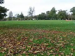 Headstone Manor Recreation Ground in autumn | |
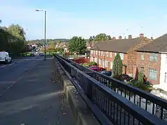 Courtenay Avenue Average housing stock in Headstone Harrow Weald Common is in the background | |
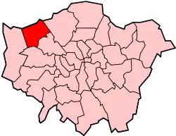
 Headstone Location within Greater London | |
| Population | 21,228 (2011 Census. Headstone North and South Wards)[1] |
| OS grid reference | TQ138907 |
| London borough | |
| Ceremonial county | Greater London |
| Region | |
| Country | England |
| Sovereign state | United Kingdom |
| Post town | HARROW |
| Postcode district | HA2, HA3 |
| Dialling code | 020 |
| Police | Metropolitan |
| Fire | London |
| Ambulance | London |
| London Assembly | |
History
Headstone Manor is fourteenth century with many later additions and renovations: it is a significant place of interest in its own right. The manor had an unrivalled status, see manorialism until after the Reformation and formation of the British Empire and to an extent, usually for such a site, relatively close to London, even until the Enlightenment which sparked the Industrial Revolution. This has led to the barns having remained largely intact to the present.[2]
The origin of the place name may be related to that of Wealdstone, which is a neighbouring area situated directly north of Harrow being the residential part north of its midpoint train station, Harrow & Wealdstone – this area acts as a second tier commercial hub for the area, the main hub being the Harrow shopping precincts and centres closer to Harrow-on-the-Hill station just 0.5 miles (0.80 km) south of Harrow & Wealdstone.
Housing
| Estate name | Area | No of dwellings | Population 1938 | Population density |
|---|---|---|---|---|
| Pre-1914 | ||||
| Norbury | 11 | 218 | 867 | 19.8 per acre (49/ha) |
| Old Oak | 32 | 736 | 3519 | 23 per acre (57/ha) |
| Totterdown Fields | 39 | 1262 | — | 32.4 per acre (80/ha) |
| Tower Gardens White Hart Lane | 98 | 783 | 5936 | 8 per acre (20/ha) |
| 1919–1923 | ||||
| Becontree | 2770 | 25769[lower-alpha 1] | 115652 | 9.3 per acre (23/ha) |
| Bellingham | 252 | 2673 | 12004 | 10.6 per acre (26/ha) |
| Castelnau | 51 | 644 | 2851 | 12.6 per acre (31/ha) |
| Dover House Estate Roehampton Estate | 147 | 1212 | 5383 | 8.2 per acre (20/ha) |
| 1924–1933 | ||||
| Downham | 600 | 7096 | 30032 | 11.8 per acre (29/ha) |
| Mottingham | 202 | 2337 | 9009 | 11.6 per acre (29/ha) |
| St Helier | 825 | 9068 | 39877 | 11 per acre (27/ha) |
| Watling | 386 | 4034 | 19110 | 10.5 per acre (26/ha) |
| Wormholt | 68 | 783 | 4078 | 11.5 per acre (28/ha) |
| 1934–1939 | ||||
| Chingford[lower-alpha 2] | 217 | 1540 | — | 7.1 per acre (18/ha) |
| Hanwell (Ealing) | 140 | 1587 | 6732 | 11.3 per acre (28/ha) |
| Headstone Lane | 142 | n.a | 5000 | |
| Kenmore Park | 58 | 654 | 2078 | 11.3 per acre (28/ha) |
| Thornhill (Royal Borough of Greenwich) | 21 | 380 | 1598 | 18.1 per acre (45/ha) |
| Whitefoot Lane (Downham) | 49 | n.a | n.a. | |
| Source:*Yelling, J.A. (1995). "Banishing London's slums: The interwar cottage estates" (PDF). Transactions. London and Middlesex Archeological Society. 46: 167–173. Retrieved 19 December 2016. Quotes: Rubinstein, 1991, Just like the country. |
|
There is a large LCC cottage estate built on 153 acres (62 ha) south of the Uxbridge road housing 5,000 people.
Headstone South is predominantly made up of 1930s semi-detached housing.[3]
Amenities
Harrow Weald Common adjoins the northern border of the area, open for walking and mountain biking equally, this is on the northern boundary of Harrow Weald (marked by Uxbridge Road). On this common which rises steeply in the north to climb the hill of Weald Wood, towards the southwestern, Headstone, side is the Bannister Sports Centre, an athletics track and training ground.
Pinner Park features a miniature railway and a cricket ground with pavilion.
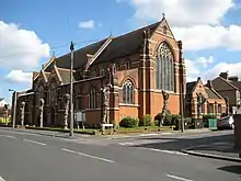
St George's Anglican parish church, serving the area, was built by John Samuel Alder and consecrated in 1911.
Transport
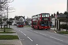
The area benefits from frequent bus services towards the more commercialised Harrow, to Hatch End very close to the north, to Pinner south-westwards and Stanmore, north-eastwards.
Headstone Lane railway station has three trains per hour in both directions. The station is on the line between Watford Junction and London Euston, providing a fast but stopping service to these destinations and a therefore less convenient service without changing once for destinations of Aylesbury and Milton Keynes; it marks the heart of the neighbourhood, parts of which around the manor recreation grounds merge seamlessly with the area to the south, North Harrow.
Nearest Settlements | ||||||||||
|---|---|---|---|---|---|---|---|---|---|---|
| ||||||||||
Notes
- North Harrow, like many London suburbs such as East Dulwich, is to the geographer a misnomer; however is north-west of the older Harrow-on-the-Hill and named after its station, which required a name; from Harrow-on-the-Hill there is a particularly straight road called The Ridgeway. It is thus centred west-northwest of Harrow.
References
- Combined population for the 2 Headstone Wards. 2011
- Historic England. "Details from listed building database (1005558)". National Heritage List for England. Retrieved 18 August 2012. Headstone Manor – older, scheduled ancient monument listing in respect of its moated site. Two barns also have listed status – as has the building listed at Grade I – Historic England. "Details from listed building database (1285855)". National Heritage List for England. Retrieved 18 August 2012.
- https://www2.harrow.gov.uk/documents/s152635/Ward%20boundary%20-%20Appendix%20B.pdf
| Districts |
|  | ||
|---|---|---|---|---|
| Attractions | ||||
| Parks and open spaces | ||||
| Constituencies | ||||
| Tube and rail stations | ||||
| Other topics | ||||
| ||||