Bellingham, London
Bellingham is an area of South East London, England, within the London Borough of Lewisham. It lies south of Catford and north-west of Beckenham, and is part of the Catford postal district (SE6).
| Bellingham | |
|---|---|
.jpg.webp) St Dunstan's Church, Bellingham | |
 Bellingham Location within Greater London | |
| Population | 14,775 (2011 Census. Ward)[1] |
| OS grid reference | TQ375715 |
| London borough | |
| Ceremonial county | Greater London |
| Region | |
| Country | England |
| Sovereign state | United Kingdom |
| Post town | LONDON |
| Postcode district | SE6 |
| Dialling code | 020 |
| Police | Metropolitan |
| Fire | London |
| Ambulance | London |
| UK Parliament | |
| London Assembly | |
Context
| Estate name | Area | No of dwellings | Population 1938 | Population density |
|---|---|---|---|---|
| Pre-1914 | ||||
| Norbury | 11 | 218 | 867 | 19.8 per acre (49/ha) |
| Old Oak | 32 | 736 | 3519 | 23 per acre (57/ha) |
| Totterdown Fields | 39 | 1262 | — | 32.4 per acre (80/ha) |
| Tower Gardens White Hart Lane | 98 | 783 | 5936 | 8 per acre (20/ha) |
| 1919–1923 | ||||
| Becontree | 2770 | 25769[lower-alpha 1] | 115652 | 9.3 per acre (23/ha) |
| Bellingham | 252 | 2673 | 12004 | 10.6 per acre (26/ha) |
| Castelnau | 51 | 644 | 2851 | 12.6 per acre (31/ha) |
| Dover House Estate Roehampton Estate | 147 | 1212 | 5383 | 8.2 per acre (20/ha) |
| 1924–1933 | ||||
| Downham | 600 | 7096 | 30032 | 11.8 per acre (29/ha) |
| Mottingham | 202 | 2337 | 9009 | 11.6 per acre (29/ha) |
| St Helier | 825 | 9068 | 39877 | 11 per acre (27/ha) |
| Watling | 386 | 4034 | 19110 | 10.5 per acre (26/ha) |
| Wormholt | 68 | 783 | 4078 | 11.5 per acre (28/ha) |
| 1934–1939 | ||||
| Chingford[lower-alpha 2] | 217 | 1540 | — | 7.1 per acre (18/ha) |
| Hanwell (Ealing) | 140 | 1587 | 6732 | 11.3 per acre (28/ha) |
| Headstone Lane | 142 | n.a | 5000 | |
| Kenmore Park | 58 | 654 | 2078 | 11.3 per acre (28/ha) |
| Thornhill (Royal Borough of Greenwich) | 21 | 380 | 1598 | 18.1 per acre (45/ha) |
| Whitefoot Lane (Downham) | 49 | n.a | n.a. | |
| Source:*Yelling, J.A. (1995). "Banishing London's slums: The interwar cottage estates" (PDF). Transactions. London and Middlesex Archeological Society. 46: 167–173. Retrieved 19 December 2016. Quotes: Rubinstein, 1991, Just like the country. |
|
According to author and historian Nick Barratt, there was certainly a Saxon community at Bellingham.[2]
Some streets in Bellingham are named after the Saxon king Alfred the Great and his extended family: King Alfred Avenue, Elfrida Crescent and Arnulf Street.
The Bellingham Estate is a London County Council cottage estate bordered to the east and west by railway lines running south from Catford. Along the south it is bordered by Southend Lane, the A2218 main road. The River Ravensbourne runs through Bellingham, although it is either underground or part of a man-made section of the river. The Prime Meridian passes to the east of Bellingham.
Randlesdown Road serves as a mini 'High Street' for Bellingham providing a local supermarket, men's and women's hair dressers, dry cleaner, off licence, news agent, fish and chip shop, pub, various takeaways and a gym (situated on Bellingham playing fields). It is known for being a very multicultural area.
Transport
Bellingham railway station serves the area with services to Kentish Town (London Blackfriars on Sundays) via Catford and to Sevenoaks via Swanley. Bellingham is served by many Transport for London buses connecting it with areas including Beckenham, Biggin Hill, Bromley, Catford, Central London, Greenwich, Shoreditch, Camberwell, Bermondsey, Deptford, Elephant & Castle, Brockley, Lewisham, New Cross, Orpington, Peckham and Woolwich.
Pre-school and primary education
Pre-schools, nurseries and kindergartens include Kindergarten Forest Hill in Bellingham Green and Umbrella House Day Nursery. Primary schools in Bellingham include Athelney Primary School and Elfrida Primary School.
Image gallery
- Bellingham Estate, London Borough of Lewisham
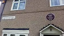 Plaque showing former home of heavyweight boxing champion Henry Cooper at 120 Farmstead Road, Bellingham, London Borough of Lewisham
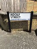 Adolf Street in the Bellingham Estate which was constructed during Adolf Hitler's rise to power as leader of the German Nationalist Socialist Party
References
- "Lewisham Ward population 2011". Neighbourhood Statistics. Office for National Statistics. Retrieved 13 October 2016.
- Barratt, Nick (2012). Greater London - The Story of the Suburbs. Vauxhall Bridge Road, London: Random House. p. 512. ISBN 9781847945327.
| Districts | 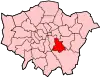 | |
|---|---|---|
| Attractions | ||
| Parks and open spaces |
| |
| Constituencies | ||
| Rail stations | ||
| Other topics | ||
| ||