Hendricks Head Light
Hendricks Head Light is a lighthouse in Southport, Maine marking the west side of the mouth of the Sheepscot River. The light station was established in 1829, and its present structures date to 1875. It was deactivated in 1933, but relit in 1951. The two-story wood keeper's house is now a private summer residence. The light is on continuously, showing white to the west and red to the east. It was listed on the National Register of Historic Places as Hendricks Head Light Station on November 20, 1987.[4]
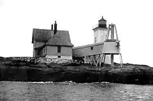 Undated US Coast Guard photo | |
 Hendricks Head Light | |

| |
| Location | Sheepscot River, Maine |
|---|---|
| Coordinates | 43°49′21.282″N 69°41′23.011″W |
| Year first constructed | 1829 |
| Year first lit | 1875 (current structure) |
| Automated | 1975 |
| Deactivated | 1933-1951 |
| Tower shape | Square Brick Tower |
| Markings / pattern | White |
| Tower height | 12 metre |
| Focal height | 43 feet (13 m) |
| Original lens | 4th order Fresnel lens |
| Current lens | 9.8 inches (250 mm) |
| Range | 9 nautical miles (17 km; 10 mi) & 7 nautical miles (13 km; 8.1 mi) |
| Characteristic | F W with R sector |
| Fog signal | Bell originally now none |
| Admiralty number | J0144 |
| ARLHS number | USA-597 |
| USCG number | 1-5665[1][2][3] |
| Heritage | place listed on the National Register of Historic Places |
Hendricks Head Light Station | |
| Nearest city | West Southport, Maine |
| Built | 1875 |
| Architect | US Army Corps of Engineers |
| MPS | Light Stations of Maine MPS |
| NRHP reference No. | 87002024[4] |
| Added to NRHP | November 20, 1987 |
Description and history
The town of Southport occupies an eponymous island on the Mid Coast of Maine, separating the Sheepscot River from the Boothbay Harbor. Hendricks Head is a peninsula extending southwest on the northern part of the island's western shore, and marks the westernmost point of the island. The lighthouse is located at the tip of the peninsula. The station includes a tower, keeper's house, fog bell tower, shed, and oil house. The tower is a tapered square-shingled wood-frame structure, topped by an octagonal lantern house. It was originally connected to the keeper's house via a covered walkway. The keeper's house is a T-shaped 2 1⁄2-story wood-frame building. The bell tower is a roughly pyramidal structure, with a central enclosed section housing the bell.[5]
The light station was established in 1829 to mark the mouth of the Sheepscot River, which provided access to the then-important shipbuilding and port center of Wiscasset. The original light station consisted of a keeper's house, built on a rubble foundation, with the lantern house mounted on top. The present tower and keeper's house were built in 1875, the house on the foundation of the previous building.[5]
References
- "Historic Light Station Information and Photography: Maine". United States Coast Guard Historian's Office. 2009-08-06. Archived from the original on 2017-05-01.
- United States Coast Guard (2009). Light List, Volume I, Atlantic Coast, St. Croix River, Maine to Shrewsbury River, New Jersey. p. 49.
- Rowlett, Russ (2009-10-09). "Lighthouses of the United States: Southern Maine". The Lighthouse Directory. University of North Carolina at Chapel Hill.
- "National Register Information System". National Register of Historic Places. National Park Service. March 13, 2009.
- "NRHP nomination for Hendricks Head Light". National Park Service. Retrieved 2016-04-24.
External links
![]() Media related to Hendricks Head Light at Wikimedia Commons
Media related to Hendricks Head Light at Wikimedia Commons
- Hendricks Head Light, Website created by current owners of lighthouse about its history.

| Topics | |
|---|---|
| Lists by state |
|
| Lists by insular areas | |
| Lists by associated state | |
| Other areas | |
| Related | |
| |
