Henstead with Hulver Street
Henstead with Hulver Street is a civil parish in the East Suffolk district, in the county of Suffolk, England. The parish includes the village of Henstead and the hamlet of Hulver Street. In 2011 the parish had a population of 402.[1] The parish touches Benacre, Ellough, Gisleham, Kessingland, Mutford, Rushmere, Sotterley and Wrentham.[2]
Henstead with Hulver Street | |
|---|---|
Civil parish | |
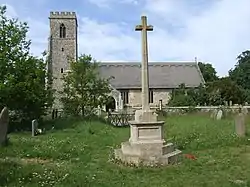 Henstead church | |
| Coordinates: 52.421607°N 1.6455674°E | |
| Country | England |
| Primary council | East Suffolk |
| County | Suffolk |
| Region | East of England |
| Status | Parish |
| Settlements | Henstead and Hulver Street |
| Area | |
| • Total | 11 km2 (4 sq mi) |
| Population (2011) | |
| • Total | 402 |
| • Density | 37/km2 (95/sq mi) |
| Website | http://hensteadwithhulverstreet.suffolk.cloud/ |
Features
There are 8 listed buildings in Henstead with Hulver Street.[3]
Demographics
It had a population of 408 in 2011, according to the census in all that year.[4]
Prior to becoming part of East Suffolk District on 1 April 2019, Henstead was in the district of Waveney. On average, the different parishes and towns in Waveney are very similar in terms of job opportunities, and population structure.
In terms of Waveney's population and its qualifications:
Waveney has 20% less Higher and Intermediate managerial qualifications, administrative qualifications than the national average.[5]
Waveney has a particularly elderly-heavy age structure, as it is a peaceful, rural area.
The population of Henstead as a whole, is older than the national average. The population of Waveney is also older than the Suffolk average, making Henstead an older persons location, much like the rest of Waveney, Waveney's mean age is 43.9, compared to the national average of 39.[6]
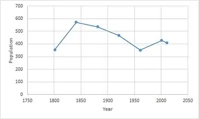
This graph illustrates how the population of Henstead has changed over time. It grew rapidly from 1800 to 1840, going from 355 to 590 in that period. It decreased steadily after this period, going from 590 in 1840 to 345 in 1960. The last census in 2011 showed the population is now 408. This shows that Henstead has always had an average population of around 400, and has never expanded into a larger civil parish, it has never experienced rapid economic growth. This is due to many factors, one of which is its lack of infrastructure, and lack of investment in services by the governing bodies of Henstead.
The number of households in Henstead has never rapidly increased, it has always stayed relatively the same; between 1900 and 1960 it has gradually increased from 110 to 122.[7]
Employment

Henstead is a rural area, therefore employment opportunities are not as high as they are in urban areas. Employment is predominantly in agriculture, produce, and textiles. However, there are other professions, such as policing, medical services, council services, and domestic offices or services.
References
- "Henstead with Hulver Street". City Population. Retrieved 27 May 2020.
- "Henstead with Hulver Street". Ordnance Survey. Retrieved 27 May 2020.
- "Listed buildings in Henstead with Hulver Street, Waveney, Suffolk". British Listed Buildings. Retrieved 27 May 2020.
- "Henstead : Key figures for 2011 Census: Key Statistics". Neighbourhood Statistics. Office for National Statistics. Retrieved 28 January 2016.
- "Henstead, Suffolk". iLiveHere - Britain's worst places to live. 2012-04-16. Retrieved 2016-03-19.
- "Henstead, Suffolk". iLiveHere - Britain's worst places to live. 2012-04-16. Retrieved 2016-03-20.
- "Henstead AP/CP through time | Housing Statistics | Total Households". www.visionofbritain.org.uk. Retrieved 2016-03-22.
External links
- "Home". Henstead with Hulver Street. Retrieved 27 May 2020.
| Wikimedia Commons has media related to Henstead with Hulver Street. |