Hisor
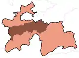
Hisor (Tajik: Ҳисор, Russian: Гиссар Gissar, Persian: حصار) is a city in western Tajikistan, about 15 km west of Dushanbe. The city was the seat of the former Hisor District, and is part of the Districts of Republican Subordination. It lies at an altitude of 799–824 m, surrounded by high mountains (Gissar Range to the north, Babatag and Aktau ranges to the south).[2] The river Khanaka, a tributary to the Kofarnihon, flows through the town. Its population is estimated at 29,100 for the city proper and 308,100 for the city with the outlying communities (2020).[3] As of 2002, its population was composed 81.6% of Tajiks, 12.3% Uzbeks, 3.6% Russians, and 2.5% others.
Hisor | |
|---|---|
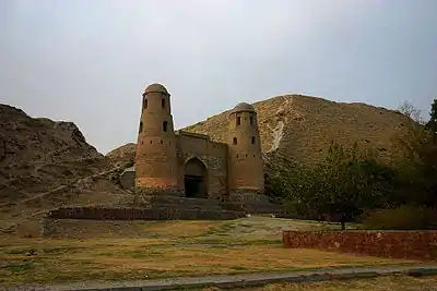 Old castle in Hisor | |
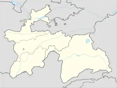 Hisor Location in Tajikistan | |
| Coordinates: 38.5264°N 68.5381°E | |
| Country | |
| Region | Districts of Republican Subordination |
| Elevation | 802 m (2,631 ft) |
| Population (2020) | |
| • City | 308,100 |
| • Urban | 29,100 |
| Time zone | UTC+5 |
It was once an independent Khanate, and then the winter residence of the governor of East Bukhara. The large fort is said to date back to Cyrus the Great and to have been captured twenty one times.[4]
Hisor was made a city on June 26, 1993.
Subdivisions
Before ca. 2018, Hisor was the seat of Hisor District, which covered the rural part of the present city of Hisor.[5] The city of Hisor covers Hisor proper, the town Sharora and ten jamoats.[6] These are as follows:[7]
| Jamoat | Population (Jan. 2015)[7] |
|---|---|
| Sharora (town) | 12,700[5] |
| Almosi | 21,261 |
| Dehqonobod | 20,686 |
| Durbat | 20,052 |
| Hisor | 32,912 |
| Khonaqohikuhi | 27,624 |
| Mirzo Rizo | 25,971 |
| Mirzo Tursunzoda | 20,303 |
| Oriyon | |
| Navobod | 26,321 |
| Somon | 28,691 |
Geography
Climate
Hisor has a hot-summer Mediterranean climate (Köppen climate classification Csa). The average annual temperature is 14.1 °C (57.4 °F). The warmest month is July with an average temperature of 23.9 °C (79.2 °F) and the coolest month is January with an average temperature of 1.7 °C (35.1 °F). The average annual precipitation is 568mm (22.4") and has an average of 90.5 days with precipitation. The wettest month is March with an average of 107.2mm (4.2") of precipitation and the driest month is August with an average of 0.8mm (0.03") of precipitation.[1]
| Climate data for Hisor | |||||||||||||
|---|---|---|---|---|---|---|---|---|---|---|---|---|---|
| Month | Jan | Feb | Mar | Apr | May | Jun | Jul | Aug | Sep | Oct | Nov | Dec | Year |
| Daily mean °C (°F) | 1.7 (35.1) |
3.2 (37.8) |
8.5 (47.3) |
14.6 (58.3) |
18.9 (66.0) |
23.9 (75.0) |
26.2 (79.2) |
24.6 (76.3) |
19.9 (67.8) |
14.2 (57.6) |
9.0 (48.2) |
4.6 (40.3) |
14.1 (57.4) |
| Average precipitation mm (inches) | 65.7 (2.59) |
73.4 (2.89) |
107.2 (4.22) |
105.0 (4.13) |
86.2 (3.39) |
7.4 (0.29) |
3.8 (0.15) |
0.8 (0.03) |
3.1 (0.12) |
30.8 (1.21) |
43.2 (1.70) |
59.4 (2.34) |
568.0 (22.36) |
| Average precipitation days (≥ 0.1 mm) | 11.0 | 12.2 | 14.8 | 12.9 | 10.2 | 2.9 | 1.5 | 0.6 | 1.1 | 5.4 | 7.3 | 10.6 | 90.5 |
| Average relative humidity (%) | 67.7 | 66.8 | 63.8 | 60.6 | 54.0 | 41.3 | 39.3 | 40.6 | 43.1 | 52.1 | 57.9 | 65.6 | 54.4 |
| Source: "The Climate of Hisor". Weatherbase. Retrieved 2 August 2014. | |||||||||||||
References
- "Climate of Hisor". Weatherbase. Retrieved 4 August 2014.
- Atlas of Soviet Republics of Central Asia, Moscow, 1988, in Russian, p. 48.
- "Population of the Republic of Tajikistan as of 1 January 2020" (PDF) (in Russian). Statistics office of Tajikistan. Retrieved 8 October 2020.
- "Hisor and Hisor Fortress travel guide". Caravanistan. Retrieved 2019-08-23.
- "Population of the Republic of Tajikistan as of 1 January 2015" (PDF) (in Russian). Statistics office of Tajikistan. Archived from the original (PDF) on 2 July 2015.
- "Regions of the Republic of Tajikistan 2017" (PDF) (in Russian). Statistics office of Tajikistan. pp. 15–21. Retrieved 12 October 2020.
- Jamoat-level basic indicators, United Nations Development Programme in Tajikistan, accessed 8 October 2020
External links
![]() Media related to Hisor at Wikimedia Commons
Media related to Hisor at Wikimedia Commons
Capital: Dushanbe | |||||||||||||||||||||||
|  | ||||||||||||||||||||||
|
| |||||||||||||||||||||||
| |||||||||||||||||||||||
| |||||||||||||||||||||||
