Sangvor District
Sangvor District (Tajik: Ноҳияи Сангвор Nohiyai Sangvor, before 2016: Tavildara District)[1] is a district of Tajikistan. It lies in the eastern part of the Districts of Republican Subordination, extending north of the Darvaz Range that forms the boundary of the Gorno-Badakhshan Autonomous Region (GBAO). Its northern boundary stretches along Rasht, Tojikobod, and Lakhsh districts. Its capital is Tavildara. The population of the district is 23,300 (January 2020 estimate).[2]
Sangvor District
(Tajik: Ноҳияи Файзобод) | |
|---|---|
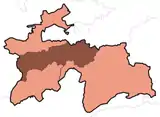
 Location of the district in Tajikistan | |
| Coordinates: 38°55′N 71°00′E | |
| Country | |
| Region | Districts of Republican Subordination |
| Capital | Tavildara |
| Area | |
| • Total | 6,000 km2 (2,000 sq mi) |
| Population (2020) | |
| • Total | 23,300 |
| • Density | 3.9/km2 (10/sq mi) |
| Time zone | UTC+5 |
| Website | sangvor |
Administrative divisions
The district has an area of about 6,000 km2 (2,000 sq mi) and is divided administratively into one five jamoats.[3] They are as follows:[4]
| Jamoat | Population (Jan. 2015)[4] |
|---|---|
| Childara | 5,841 |
| Sangvor | 4,785 |
| Tavildara | 5,950 |
| Vahdat | |
| Vakhiyo | |
Gallery
.jpg.webp)
.jpg.webp)
.jpg.webp)
References
- "Renaming of 10 cities and districts, and Kayrakkum Reservoir" (in Russian). 1 February 2016. Retrieved 7 October 2020.
- "Population of the Republic of Tajikistan as of 1 January 2020" (PDF) (in Russian). Statistics office of Tajikistan. Retrieved 13 October 2020.
- "Regions of the Republic of Tajikistan 2017" (PDF) (in Russian). Statistics office of Tajikistan. pp. 17, 21. Retrieved 13 October 2020.
- Jamoat-level basic indicators, United Nations Development Programme in Tajikistan, accessed 13 October 2020
Capital: Dushanbe | |||||||||||||||||||||||
|  | ||||||||||||||||||||||
|
| |||||||||||||||||||||||
| |||||||||||||||||||||||
| |||||||||||||||||||||||
This article is issued from Wikipedia. The text is licensed under Creative Commons - Attribution - Sharealike. Additional terms may apply for the media files.