Tojikobod District
Tojikobod District (Tajik: Ноҳияи Тоҷикобод, Nohiyai Tojikobod, Russian transliteration: Tadzhikabad) is a district in Tajikistan, one of the Districts of Republican Subordination. It is surrounded by Sangvor District from the south, Lakhsh District from the north-east, and Rasht District from the north-west. Its capital is the village Tojikobod. The population of the district is 46,000 (January 2020 estimate).[1]
Tojikobod District
(Tajik: Ноҳияи Тоҷикобод) | |
|---|---|
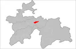 Location of the district in Tajikistan | |
| Coordinates: 39°05′N 70°50′E | |
| Country | |
| Region | Districts of Republican Subordination |
| Capital | Tojikobod |
| Area | |
| • Total | 700 km2 (300 sq mi) |
| Population (2020) | |
| • Total | 46,000 |
| • Density | 66/km2 (170/sq mi) |
| Time zone | UTC+5 |
| Website | tojikobod |
Administrative divisions
The district has an area of about 700 km2 (300 sq mi) and is divided administratively into five jamoats.[2] They are as follows:[3]
| Jamoat | Population (Jan. 2015)[3] |
|---|---|
| Langarisho | 10,360 |
| Nushor | 11,608 |
| Qalailabiob | 11,102 |
| Shirinchashma | |
| Shogadoev | 5,162 |
References
- "Population of the Republic of Tajikistan as of 1 January 2020" (PDF) (in Russian). Statistics office of Tajikistan. Retrieved 13 October 2020.
- "Regions of the Republic of Tajikistan 2017" (PDF) (in Russian). Statistics office of Tajikistan. pp. 17, 21. Retrieved 13 October 2020.
- Jamoat-level basic indicators, United Nations Development Programme in Tajikistan, accessed 13 October 2020
Capital: Dushanbe | |||||||||||||||||||||||
|  | ||||||||||||||||||||||
|
| |||||||||||||||||||||||
| |||||||||||||||||||||||
| |||||||||||||||||||||||
This article is issued from Wikipedia. The text is licensed under Creative Commons - Attribution - Sharealike. Additional terms may apply for the media files.