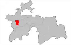
Varzob District
Varzob District (Tajik: Ноҳияи Варзоб, romanized: Nohiyayi Varzob) is a district in Tajikistan, lying north of Dushanbe. It is one of the Districts of Republican Subordination. It borders on the city of Hisor from the west, Rudaki District from the south, and the city of Vahdat from the east. The Gissar Range runs along its northern edge. The river Varzob traverses the entire district north to south. The district capital is the village Varzob. The population of the district is 82,200 (January 2020 estimate).[1]
Varzob District
(Tajik: Ноҳияи Файзобод) | |
|---|---|
 Location of the district in Tajikistan | |
| Coordinates: 38°50′N 68°50′E | |
| Country | |
| Region | Districts of Republican Subordination |
| Capital | Varzob |
| Area | |
| • Total | 1,700 km2 (700 sq mi) |
| Population (2020) | |
| • Total | 82,200 |
| • Density | 48/km2 (130/sq mi) |
| Time zone | UTC+5 |
| Website | varzob |
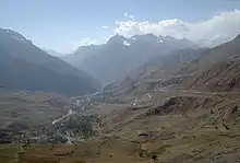
Beside the river, grows a native species of Iris vicaria,[2] and Iris hoogiana.[3]
Administrative divisions
The district has an area of about 1,700 km2 (700 sq mi) and is divided administratively into one town and six jamoats.[4] They are as follows:[5]
| Jamoat | Population (Jan. 2015)[5] |
|---|---|
| Takob (town) | 2,400[6] |
| Ayni | 14,052 |
| Chorbogh | 31,585 |
| Dehmalik | 8,034 |
| Luchob | 7,174 |
| Varzobqala | 11,438 |
| Zideh | 7,219 |
References
- "Population of the Republic of Tajikistan as of 1 January 2020" (PDF) (in Russian). Statistics office of Tajikistan. Retrieved 13 October 2020.
- "Ornamental plants in their natural habitats". mobot.org. Retrieved 20 September 2014.
- "Regeliocyclus hybrids". hillkeep.ca. Retrieved 5 June 2015.
- "Regions of the Republic of Tajikistan 2017" (PDF) (in Russian). Statistics office of Tajikistan. pp. 17, 21. Retrieved 13 October 2020.
- Jamoat-level basic indicators, United Nations Development Programme in Tajikistan, accessed 13 October 2020
- "Population of the Republic of Tajikistan as of 1 January 2015" (PDF) (in Russian). Statistics office of Tajikistan. Archived from the original (PDF) on 2 July 2015.
Capital: Dushanbe | |||||||||||||||||||||||
|  | ||||||||||||||||||||||
|
| |||||||||||||||||||||||
| |||||||||||||||||||||||
| |||||||||||||||||||||||
This article is issued from Wikipedia. The text is licensed under Creative Commons - Attribution - Sharealike. Additional terms may apply for the media files.
