Rudaki District
Rudaki District (Tajik: Ноҳияи Рӯдакӣ Nohiyai Rudaki) is a district in Tajikistan, one of the Districts of Republican Subordination. It stretches south from Dushanbe, bordering on Shahrinav District, the city of Hisor, and Varzob District from the north and northwest, Tajikistan's Khatlon Region from the south and the east, and Uzbekistan from the west. Its administrative capital is Somoniyon, a southern suburb of Dushanbe, called Leninsky in the Soviet period.[1] The population of the district is 518,200 (January 2020 estimate).[2]
Rudaki District
(Tajik: Ноҳияи Рӯдакӣ) | |
|---|---|
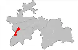 Location of the district in Tajikistan | |
| Coordinates: 38°21′N 68°37′E | |
| Country | |
| Region | Districts of Republican Subordination |
| Capital | Somoniyon |
| Area | |
| • Total | 1,800 km2 (700 sq mi) |
| Population (2020) | |
| • Total | 518,200 |
| • Density | 290/km2 (750/sq mi) |
| Time zone | UTC+5 |
| Website | nrudaki |
A border guard training center is located here, used by the Tajik Border Troops.[3] In October 2013, the Tajik Interior Ministry opened a new police station in the district.[4]
Administrative divisions
The district has an area of about 1,800 km2 (700 sq mi) and is divided administratively into three towns and thirteen jamoats.[5] They are as follows:[6]
| Jamoat | Population (Jan. 2015)[6] |
|---|---|
| Navobod (town) | 9,100[7] |
| Somoniyon (town) | 22,600[7] |
| Mirzo Tursunzoda (town) | 17,900[7] |
| Chimteppa | 45,221 |
| Chorgulteppa | 37,551 |
| Chorteppa | 32,076 |
| Choryakkoron | |
| Esanboy | 20,072 |
| Guliston | 41,130 |
| Kiblai | 13,860 |
| Lohur | 20,047 |
| Rohati | 32,152 |
| Rossiya | 31,030 |
| Sarikishti | 38,474 |
| Sultonobod | 16,066 |
| Zainabobod | 36,844 |
References
- Republic of Tajikistan, map showing administrative division as of January 1, 2004, "Tojikkoinot" Cartographic Press, Dushanbe
- "Population of the Republic of Tajikistan as of 1 January 2020" (PDF) (in Russian). Statistics office of Tajikistan. Retrieved 13 October 2020.
- "OSCE supports training for Tajik border guard services on refugees and asylum issues | OSCE". www.osce.org. Retrieved 2016-05-21.
- "In Rudaki district opened a new territorial police station". www.vkd.tj. Archived from the original on 2016-06-17. Retrieved 2016-05-21.
- "Regions of the Republic of Tajikistan 2017" (PDF) (in Russian). Statistics office of Tajikistan. pp. 17, 21. Retrieved 13 October 2020.
- Jamoat-level basic indicators, United Nations Development Programme in Tajikistan, accessed 13 October 2020
- "Population of the Republic of Tajikistan as of 1 January 2015" (PDF) (in Russian). Statistics office of Tajikistan. Archived from the original (PDF) on 2 July 2015.
Capital: Dushanbe | |||||||||||||||||||||||
|  | ||||||||||||||||||||||
|
| |||||||||||||||||||||||
| |||||||||||||||||||||||
| |||||||||||||||||||||||
