Nurobod District, Tajikistan
Nurobod District (Tajik: Ноҳияи Нуробод, Russian spelling: Nurabad District) is a district in Tajikistan, one of the 9 Districts of Republican Subordination. Formerly known as Darband District, Nurobod District lies east of the city of Roghun, south of the city of Vahdat and Rasht District, and west of Sangvor District. Its southern border is with the Khatlon Region. The capital of Nurobod District is the town Darband. The population of the district is 82,100 (January 2020 estimate).[1]
Nurobod District
(Tajik: Ноҳияи Нуробод) | |
|---|---|
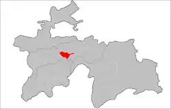 Location of the district in Tajikistan | |
| Coordinates: 38°51′N 70°05′E | |
| Country | |
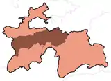
| Region | Districts of Republican Subordination |
| Capital | Darband |
| Area | |
| • Total | 900 km2 (300 sq mi) |
| Population (2020) | |
| • Total | 82,100 |
| • Density | 91/km2 (240/sq mi) |
| Time zone | UTC+5 |
| Website | www |
Administrative divisions
The district has an area of about 900 km2 (300 sq mi) and is divided administratively into one town and six jamoats.[2] They are as follows:[3]
| Jamoat | Population (Jan. 2015)[3] |
|---|---|
| Darband (town) | 1,200[4] |
| Hakimi | 13,666 |
| Izzatullo Halimov | 8,035 |
| Humdon | |
| Komsomolobod | 15,046 |
| Mujiharf | 17,366 |
| Safedchashma | 8,015 |
References
- "Population of the Republic of Tajikistan as of 1 January 2020" (PDF) (in Russian). Statistics office of Tajikistan. Retrieved 13 October 2020.
- "Regions of the Republic of Tajikistan 2017" (PDF) (in Russian). Statistics office of Tajikistan. pp. 17, 21. Retrieved 13 October 2020.
- Jamoat-level basic indicators, United Nations Development Programme in Tajikistan, accessed 13 October 2020
- "Population of the Republic of Tajikistan as of 1 January 2015" (PDF) (in Russian). Statistics office of Tajikistan. Archived from the original (PDF) on 2 July 2015.
Capital: Dushanbe | |||||||||||||||||||||||
|  | ||||||||||||||||||||||
|
| |||||||||||||||||||||||
| |||||||||||||||||||||||
| |||||||||||||||||||||||
This article is issued from Wikipedia. The text is licensed under Creative Commons - Attribution - Sharealike. Additional terms may apply for the media files.