Hoy
Hoy (Scots: Hoy; from Norse Háey meaning "high island") is an island in Orkney, Scotland, measuring 143 square kilometres (55 sq mi) — ranked largest in the archipelago after Mainland. A natural causeway, the Ayre, links to much smaller South Walls; the two islands are treated as one entity by the UK census.[4][9]
| Scots name | Hoy[1] |
|---|---|
| Old Norse name | Há-øy[2] |
| Meaning of name | Old Norse for 'high island'[2] |
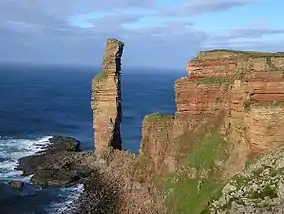 The Old Man of Hoy, at the western side of the island, seen from the south | |
| Location | |
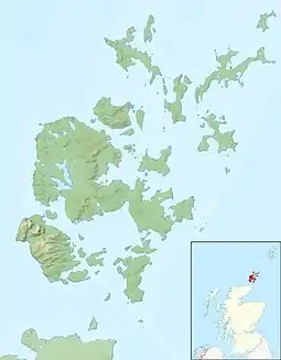 Hoy Hoy shown within Orkney | |
| OS grid reference | ND263961 |
| Coordinates | 58.83°N 3.3°W |
| Physical geography | |
| Island group | Orkney |
| Area | 14,318 ha (55 5⁄16 sq mi)[2] |
| Area rank | 12 [3] |
| Highest elevation | Ward Hill, 479 m (1,572 ft) |
| Administration | |
| Sovereign state | United Kingdom |
| Country | Scotland |
| Council area | Orkney Islands |
| Demographics | |
| Population | 419[4][Note 1] |
| Population rank | 23 [3] |
| Population density | 2.9/km2 (7.5/sq mi)[2][4] |
| Largest settlement | Lyness |
| References | [2][5][6] [7][8] |
History
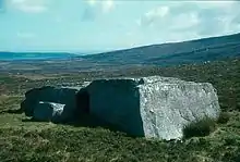
The Dwarfie Stane lies in the north of the Rackwick valley and dates back to around 5000 BCE. It is unique in northern Europe, bearing similarity to Neolithic or Bronze Age tombs around the Mediterranean. The tomb has a small rectangular entrance and cleft, hence its name.[Note 2] Discoveries have been made on the mainland of Orkney at the Ness of Brodgar that date back as early as 3510 BCE with the first stone circle in the British Isles found there.[10]
The two most northerly Martello Towers in the UK stand here, built in 1814 to defend merchant shipping in the natural harbour of Longhope against privateers commissioned by American president Madison, who declared war in 1812. Arguably, an effective deterrent as there is no record of them ever being engaged in serious combat.
World Wars
The main naval base for the British fleet in both the First and Second World Wars, Scapa Flow, was at Lyness in the southeast of the island.[11]
During the early years of World War II, up to 12,000 personnel were based in and around Lyness to support the defences of the naval anchorage at Scapa Flow and the ships that used it. To support this huge population, hundreds of accommodation huts were built in a number of camps around Lyness. A large wharf was built (known as the Golden Wharf because of its huge cost) along with a series of piers and slipways. Offices, workshops, stores and recreational buildings were erected, including a cinema, a theatre and several churches. An earlier headquarters building was replaced in 1943 by an imposing concrete HQ and communications centre, also located high on Wee Fea which now serves as a hotel.
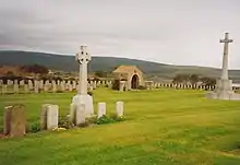
Lyness Royal Naval Cemetery is situated around 1 kilometre (1,100 yd) inland from the naval base and has an area of around 10,000 square metres (110,000 sq ft).
Demographics
Although the population of Hoy is now only around 400, there was a much larger population in the past. In 1890 there were 4 schools on the island and 4 churches suggesting a much larger population. Despite the larger population there was no paved road between the north of the island and the southern tip of the island and South Walls island, only a footpath. There was however an unsurfaced road between the two villages on the north of the isle; Rackwick and Moaness. [12] Hoy lies within the parish of Stromness.
Geography
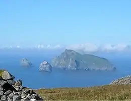
The Old Man of Hoy, a sea stack formed from Old Red Sandstone, can be found on the Rackwick coast. It is one of the tallest stacks in the United Kingdom at a height of 449 feet (137 m). The Old Man is popular with climbers, and was first climbed in 1966. Created by the erosion of a cliff through hydraulic action some time after 1750, the stack is no more than a few hundred years old, and paintings from 1817 shows the stack with an arch at the bottom which has now further eroded and no longer remains. It may soon collapse into the sea.
The dramatic coastline of Hoy can be seen by visitors traveling to Orkney by ferry from the Scottish mainland. It has some of the highest sea cliffs in the UK at St John's Head, which reach 350 metres (1,150 ft).[2]
The name Hoy comes from the Norse word Háey meaning "high island". It is therefore not surprising that the island of Hoy is the most mountainous in the Orkney archipelago. The highest point on the island (and indeed the whole archipelago is Ward Hill which stands at 481 metres (1,578 ft) and is to the north of the island. There is a trig point at the summit.
Hoy is part of the Hoy and West Mainland National Scenic Area, one of 40 in Scotland.[13]
Orkneys only woodland is found on Hoy and is the most northerly woodland in the UK. Patches of the woodland are scattered across the island and most significantly there is the remote possibility of locally extant Orkney charr (Salvelinus inframundus) documented in 1908 at Heldale Water.[14]
Transport
There is evidence that there was at one point an airfield on Hoy, possibly due to its connections with the navy. There are two suggested sites both on South Walls, one on the southern coast (Snelsetter) which opened in August 1934 and was closed at the end of World War Two. It was used by military and civil aircraft, and now is open land.[15] Another just east of the causeway that links the two islands of Hoy and South Walls. Which opened in November 1972 and closed in 1993. It was used by civilian aircraft solely and was operated by the airline Loganair it is also now open land.[16] The first flight to a nearby island of Flotta on 1 March 1977 was recorded to have landed at Hoy. Both airfields on Hoy are now disused.
Orkney Ferries traverse the west of Scapa Flow with two routes:
Longhope lifeboat station
A Lifeboat has been on Hoy since 1874 which was originally housed in a prominent stone building close to the west end of the causeway that links the two islands of Hoy and South Walls together at a cost of £228. It was stationed there as it meant that the lifeboat could be dragged over wooden skids and into the sea in either North Bay, giving access to Scapa Flow or in Aith Hope, an offshoot of the notorious Pentland Firth to the south. The shed continued to serve as the base of the Longhope lifeboat until 1906, when it was replaced.
The lifeboat station that stands slightly to the south of the original station which is now home to the Longhope Lifeboat Museum, cost £2,700 to build in 1906. It continued to serve as the base for the Longhope lifeboat until 1999. Whilst based at this station, 1969 on 17 March the lifeboat 'T.G.B.' ON 962, capsized while on service to the Liberian vessel 'Irene' and her entire crew of eight lost their lives, known as the Longhope lifeboat disaster.[12] In August of that year an Arun-class lifeboat, Sir Max Aitken II became the Longhope lifeboat. This class was designed to stay permanently afloat, and the decision was taken to move her to purpose-built moorings at Longhope pier. The lifeboats that have served here since have also been stationed at Longhope, including the current vessel the Helen Comrie (a Tamar class lifeboat) and her predecessor The Queen Mother, which was based here between 2004 and 2006. A station has been built where the lifeboat is moored at Longhope which is also the main harbour for boats to and from the island. [10]
Mythology
In Norse mythology, Hoy hosted Hjaðningavíg, the never-ending battle between Heðin and Högni.
Wildlife
Hoy is an Important Bird Area.[17][18] The northern part of the island is an RSPB reserve due to its importance for birdlife, particularly great skuas and red-throated divers. It was sold to the RSPB by the Hoy Trust for a nominal amount.[19] Anastrepta orcadensis, a liverwort also known as Orkney Notchwort, was first discovered on Ward Hill by William Jackson Hooker in 1808.[20][21]
The northern and western parts of Hoy, along with much of the adjoining sea area, is designated as a Special Protection Area[22] due to its importance for nine breeding bird species: arctic skua, fulmar, great black-backed gull, great skua, guillemot, Black-legged kittiwake, peregrine falcon, puffin and red-throated diver.[23] The area is important for its seabird assemblage, which regularly supports 120,000 individual seabirds during the breeding season.[24]
In popular culture
Hoy is featured prominently in the 1984 video for "Here Comes The Rain Again" by Eurythmics.
Hoy also has a performing arts theatre, the Gable End Theatre, which opened in 2000 and has a capacity of 75. The theatre is managed by the Hoy and Walls drama community.
Some rather incongruous Art Deco structures nearby date from this period. The Arts and Crafts architect William Lethaby rebuilt Melsetter house for mountaineer Thomas Middlemore at the end of the nineteenth century leaving untouched the adjacent barn which is probably mid-18th century.[25][26]
In Poul Anderson's story "The Bitter Bread" the protagonist lives in secluded retirement on Hoy and sets down reminiscences of his stormy life. There is a description of the island: "Steep red and yellow cliffs, sea green in sunlight or gray under clouds until it breaks in whiteness and thunder, gulls riding a cold loud wind, inland the heather and a few gnarly trees across hills where sheep graze, a hamlet of rough and gentle Orkney folk an hour's walk away, my cat, my books, my rememberings." [27]
Gallery
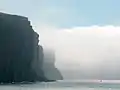 Cliffs on the Atlantic coast of Hoy, south of Rackwick
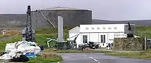 Scapa Flow Visitor Centre
 Hoy High Lighthouse on Graemsay, viewed from Mainland
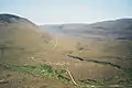 Rackwick Valley
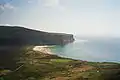 Rackwick
See also
Notes
- Including South Walls.
- Dwarfie/dwarfy is an adjective of a slightly deprecated term for any small grown human, dwarf; stane is the word stone before the Great English Vowel Shift as in most Roman roads locally or collectively recorded as "stane streets".
References
- "Map of Scotland in Scots - Guide and gazetteer" (PDF).
- Haswell-Smith, Hamish (2004). The Scottish Islands. Edinburgh: Canongate. pp. 344–6. ISBN 978-1-84195-454-7.
- Area and population ranks: there are c. 300 islands over 20 ha in extent and 93 permanently inhabited islands were listed in the 2011 census.
- National Records of Scotland (15 August 2013). "Appendix 2: Population and households on Scotland's Inhabited Islands" (PDF). Statistical Bulletin: 2011 Census: First Results on Population and Household Estimates for Scotland Release 1C (Part Two) (PDF) (Report). SG/2013/126. Retrieved 14 August 2020.
- Orkney Placenames. Orkneyjar.
- Ordnance Survey: Landranger map sheet 6 Orkney (Mainland) (Map). Ordnance Survey. 2014. ISBN 9780319228128.
- Anderson, Joseph (Ed.) (1893) Orkneyinga Saga. Translated by Jón A. Hjaltalin & Gilbert Goudie. Edinburgh. James Thin and Mercat Press (1990 reprint). ISBN 0-901824-25-9
- Pedersen, Roy (January 1992) Orkneyjar ok Katanes (map, Inverness, Nevis Print)
- General Register Office for Scotland (28 November 2003) Scotland's Census 2001 – Occasional Paper No 10: Statistics for Inhabited Islands. Retrieved 26 February 2012.
- McKie, Robin (6 October 2012). "Neolithic discovery: why Orkney is the centre of ancient Britain". The Observer. Guardian Media Group. Retrieved 23 August 2020.
- "Orkneyjar - The Dwarfie Stane, Hoy". www.orkneyjar.com. Retrieved 9 April 2020.
- observations of ordnance survey maps of the time.
- National Scenic Areas Archived 11 March 2017 at the Wayback Machine. SNH. Retrieved 30 March 2011
- "The IUCN Red List of Threatened Species". IUCN Red List of Threatened Species. Retrieved 27 October 2018.
- "Snelsetter (Hoy) - Airfields of Britain Conservation Trust UK". www.abct.org.uk. Retrieved 13 April 2020.
- "Hoy (Longhope) - Airfields of Britain Conservation Trust UK". www.abct.org.uk. Retrieved 13 April 2020.
- Important Bird Areas factsheet: Hoy Birdlife.org, Retrieved 24 January 2015
- Hoy IBA Global Species.org, Retrieved 24 January 2015
- Haswell-Smith, Hamish (1996). The Scottish Islands. Canongate. p. 283. ISBN 0-86241-579-9.
- "Bryology (mosses, liverworts and hornworts)" Royal Botanic Garden Edinburgh. Retrieved 15 May 2008.
- "West Highland Mosses And Problems They Suggest" (January 1907) Annals Of Scottish Natural History 61 p. 46. Edinburgh. Retrieved 11 June 2008.
- "Sitelink - Map Search". Scottish Natural Heritage. Retrieved 24 January 2018.
- "Site Details for Hoy (SPA)". Scottish Natural Heritage. 5 March 2018. Retrieved 21 March 2018.
- "SPA Description (Hoy)". Joint Nature Conservation Committee. 21 July 2005. Retrieved 21 March 2018.
- Tinniswood, Adrian (1999). The Arts & Crafts House. New York: Watson-Guptill Publications. pp. 34–37. ISBN 0-8230-0364-7.
- Historic Environment Scotland. "Walls (Hoy), Melsetter, The Hall, including Gatepiers to West (Category B Listed Building) (LB48367)". Retrieved 2 April 2019.
- Poul Anderson, "The Bitter Bread", Analog magazine 1975, Reprinted in.Poul Anderson, "Explorations",Tom Deherty Associates, New York, 1981. The story is set centuries in the future, but it assumes that the island of Hoy will have changed little from its present condition.
External links
| Wikimedia Commons has media related to Hoy. |
| Wikivoyage has a travel guide for Hoy. |
|  | ||||||||||||||||
|
| |||||||||||||||||
| |||||||||||||||||
| |||||||||||||||||
| |||||||||||||||||
| |||||||||||||||||
| |||||||||||||||||
| |||||||||||||||||