Johnston County, North Carolina
Johnston County is a county located in the U.S. state of North Carolina. As of the 2010 census, the population was 168,878.[1] Its county seat is Smithfield.[2]
Johnston County | |
|---|---|
| County of Johnston | |
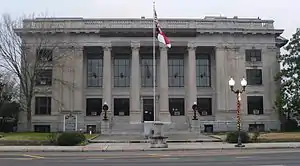 Johnston County Courthouse | |
 Seal | |
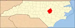
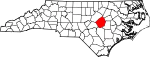 Location within the U.S. state of North Carolina | |
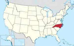 North Carolina's location within the U.S. | |
| Coordinates: 35°31′N 78°22′W | |
| Country | |
| State | |
| Founded | June 28, 1746 |
| Named for | Gabriel Johnston |
| Seat | Smithfield |
| Largest town | Clayton |
| Area | |
| • Total | 796 sq mi (2,060 km2) |
| • Land | 791 sq mi (2,050 km2) |
| • Water | 4.2 sq mi (11 km2) 0.5%% |
| Population | |
| • Estimate (2019) | 209,339 |
| • Density | 229.4/sq mi (88.6/km2) |
| Time zone | UTC−5 (Eastern) |
| • Summer (DST) | UTC−4 (EDT) |
| ZIP Codes | 27501, 27504, 27520, 27524, 27527, 27529, 27542, 27555, 27557, 27568, 27569, 27576, 27577, 27591, 27592, 27597, 27603, 28334, 28366 |
| Area code | 919, 984 |
| Congressional district | 7th |
| Website | www |
Johnston County is included in the Raleigh, NC Metropolitan Statistical Area, which is also included in the Raleigh-Durham-Chapel Hill, NC Combined Statistical Area, which has a population of 1,998,808 as of U.S. Census 2012 Population Estimates.[3]
History
The county was formed in 1746 from Craven County. It was named for Gabriel Johnston, Governor of North Carolina from 1734 to 1752.[4] In 1752 parts of Johnston County, Bladen County, and Granville County were combined to form Orange County. In 1758 the eastern part of Johnston County became Dobbs County. In 1770 parts of Johnston County, Cumberland County, and Orange County were combined to form Wake County. Finally, in 1855 parts of Johnston County, Edgecombe County, Nash County, and Wayne County were combined to form Wilson County.
Geography
According to the U.S. Census Bureau, the county has a total area of 796 square miles (2,060 km2), of which 791 square miles (2,050 km2) is land and 4.2 square miles (11 km2) (0.5%) is water.[5]
Adjacent counties
- Nash County (northeast)
- Wilson County (east)
- Wayne County (southeast)
- Sampson County (south)
- Harnett County (southwest)
- Wake County (northwest)
Demographics
| Historical population | |||
|---|---|---|---|
| Census | Pop. | %± | |
| 1790 | 5,691 | — | |
| 1800 | 6,301 | 10.7% | |
| 1810 | 6,867 | 9.0% | |
| 1820 | 9,607 | 39.9% | |
| 1830 | 10,938 | 13.9% | |
| 1840 | 10,599 | −3.1% | |
| 1850 | 13,726 | 29.5% | |
| 1860 | 15,656 | 14.1% | |
| 1870 | 16,897 | 7.9% | |
| 1880 | 23,461 | 38.8% | |
| 1890 | 27,239 | 16.1% | |
| 1900 | 32,250 | 18.4% | |
| 1910 | 41,401 | 28.4% | |
| 1920 | 48,998 | 18.3% | |
| 1930 | 57,621 | 17.6% | |
| 1940 | 63,798 | 10.7% | |
| 1950 | 65,906 | 3.3% | |
| 1960 | 62,936 | −4.5% | |
| 1970 | 61,737 | −1.9% | |
| 1980 | 70,599 | 14.4% | |
| 1990 | 81,306 | 15.2% | |
| 2000 | 121,965 | 50.0% | |
| 2010 | 168,878 | 38.5% | |
| 2019 (est.) | 209,339 | [6] | 24.0% |
| U.S. Decennial Census[7] 1790-1960[8] 1900-1990[9] 1990-2000[10] 2010-2013[1] | |||
As of the census[11] of 2000, there were 121,965 people, 46,595 households, and 33,688 families residing in the county. The population density was 154 people per square mile (59/km2). There were 50,196 housing units at an average density of 63 per square mile (24/km2). The racial makeup of the county was 78.09% White, 15.65% Black or African American, 0.41% Native American, 0.30% Asian, 0.04% Pacific Islander, 4.53% from other races, and 0.99% from two or more races. 7.74% of the population were Hispanic or Latino of any race.
There were 46,595 households, out of which 35.40% had children under the age of 18 living with them, 57.80% were married couples living together, 10.60% had a female householder with no husband present, and 27.70% were non-families. 23.10% of all households were made up of individuals, and 8.60% had someone living alone who was 65 years of age or older. The average household size was 2.58 and the average family size was 3.02.
In the county, the population was spread out, with 26.10% under the age of 18, 8.10% from 18 to 24, 34.20% from 25 to 44, 21.70% from 45 to 64, and 9.80% who were 65 years of age or older. The median age was 34 years. For every 100 females there were 98.70 males. For every 100 females age 18 and over, there were 96.30 males.
The median income for a household in the county was $40,872, and the median income for a family was $48,599. Males had a median income of $33,008 versus $25,582 for females. The per capita income for the county was $18,788. About 8.90% of families and 12.80% of the population were below the poverty line, including 16.00% of those under age 18 and 19.40% of those age 65 or over.
Government
The county is governed by the Johnston County Board of Commissioners, a seven-member board of County Commissioners, elected to serve four-year terms. The commissioners enact policies such as establishment of the property tax rate, regulation of land use and zoning outside municipal jurisdictions, and adoption of the annual budget. Commissioners generally meet each month.[12]
Current (2019) members of the Johnston County Board of Commissioners are:[13]
- Ted G. Godwin, Chairman
- Chad M. Stewart, Vice Chairman
- Jeffrey P. Carver
- Larry Wood
- Tony Braswell
- Patrick E. Harris
- R.S. "Butch" Lawter, Jr.
Rick Hester is the County Manager.
Johnston County is a member of the regional Triangle J Council of Governments. Johnston County 911 is the first 911 Agency in North Carolina to hold "Tri Accreditation" from the National Academies of Emergency Dispatch in Fire, Police, and EMD Protocols.
Politics
| Year | Republican | Democratic | Third parties |
|---|---|---|---|
| 2020 | 61.4% 68,353 | 37.1% 41,257 | 1.6% 1,747 |
| 2016 | 63.3% 54,372 | 33.0% 28,362 | 3.7% 3,175 |
| 2012 | 63.2% 48,427 | 35.6% 27,290 | 1.3% 974 |
| 2008 | 61.4% 43,622 | 37.7% 26,795 | 0.8% 600 |
| 2004 | 67.9% 36,903 | 31.8% 17,266 | 0.4% 188 |
| 2000 | 66.1% 27,212 | 33.3% 13,704 | 0.6% 239 |
| 1996 | 58.2% 18,704 | 34.8% 11,175 | 7.0% 2,240 |
| 1992 | 48.7% 15,418 | 35.6% 11,284 | 15.7% 4,977 |
| 1988 | 64.0% 15,563 | 35.8% 8,717 | 0.2% 49 |
| 1984 | 67.3% 16,210 | 32.5% 7,833 | 0.2% 37 |
| 1980 | 51.3% 10,444 | 47.1% 9,601 | 1.6% 331 |
| 1976 | 45.1% 8,511 | 54.6% 10,301 | 0.4% 67 |
| 1972 | 79.2% 14,272 | 19.4% 3,488 | 1.4% 251 |
| 1968 | 33.1% 6,764 | 22.0% 4,492 | 45.0% 9,212 |
| 1964 | 42.2% 7,523 | 57.9% 10,326 | |
| 1960 | 40.2% 6,660 | 59.8% 9,914 | |
| 1956 | 33.2% 4,893 | 66.8% 9,852 | |
| 1952 | 35.2% 5,429 | 64.8% 9,997 | |
| 1948 | 24.7% 3,211 | 70.7% 9,188 | 4.6% 598 |
| 1944 | 34.8% 4,423 | 65.2% 8,282 | |
| 1940 | 29.6% 4,192 | 70.4% 9,976 | |
| 1936 | 27.8% 4,339 | 72.2% 11,253 | |
| 1932 | 28.8% 3,887 | 70.9% 9,574 | 0.4% 50 |
| 1928 | 60.4% 7,696 | 39.6% 5,041 | |
| 1924 | 51.2% 4,910 | 48.6% 4,656 | 0.2% 23 |
| 1920 | 48.1% 5,588 | 51.9% 6,030 | |
| 1916 | 45.2% 2,857 | 54.8% 3,468 | |
| 1912 | 25.8% 1,335 | 53.3% 2,757 | 20.9% 1,083 |
| 1908 | 52.1% 2,827 | 47.8% 2,593 | 0.0% 0 |
| 1904 | 37.6% 1,553 | 62.3% 2,572 | 0.0% 0 |
| 1900 | 38.6% 1,997 | 61.0% 3,154 | 0.3% 17 |
| 1896 | 35.2% 1,824 | 64.6% 3,343 | 0.0% 2 |
| 1892 | 21.6% 1,036 | 65.4% 3,135 | 12.9% 620 |
| 1888 | 41.5% 2,129 | 58.3% 2,992 | 0.1% 7 |
| 1884 | 39.5% 1,831 | 60.5% 2,805 | 0.0% 0 |
| 1880 | 44.2% 1,631 | 55.8% 2,059 | 0.0% 0 |
Education
Higher education
Johnston County is home to Johnston Community College (JCC), a public, two-year, post-secondary college located in Smithfield, North Carolina. The college has off-campus centers throughout Johnston County.[15]
Primary and secondary education
Public education in Johnston County is served by the Johnston County School District, which has 46 schools and serves more than 35,400 students.[16] In addition, one charter schools and five private schools are located in the county.
Libraries
The Johnston County Public Affiliated Library system operates six branches throughout the county. The library system keeps books, periodicals and audio books and has recently expanded the selection to include downloadable e-books.[17] The Hocutt-Ellington Memorial Library in Clayton left the Johnston County affiliated library system in 2015.[18]
Culture
Visitor attractions in Johnston County include several heritage museums and historic sites. The Bentonville Battlefield State Historic Site is located in eastern Johnston County near Four Oaks, and it is the largest Civil War Battlefield in North Carolina. The Battle of Bentonville was fought March 19–21, 1865, and was the only Confederate offensive targeted to stop General Sherman's march through the south.
The Tobacco Farm Life Museum in Kenly has been collecting artifacts and showcasing the heritage of the Eastern North Carolina farmer for over 35 years. The site includes a museum and restored farmstead, blacksmith shop, one-room school house and the site hosts several events each year.
The Ava Gardner Museum located in Smithfield is home to an incredible collection of artifacts such as scripts, movie posters, costumes and personal belongings of screen legend, Ava Gardner, who was born and raised in Johnston County. The Ava Gardner Museum hosts visitors from around the world and holds an annual festival with new exhibits and special events.
The Johnston County Heritage Center is in Downtown Smithfield, and houses artifacts from all over the county. The Heritage Center has become known as one of the best equipped facilities in the country for studying local history and genealogy. Special exhibits on the heritage of the county are rotated in the lobby on the first floor at least once a year.
The Johnston County Arts Council promotes arts in the county and its schools.[19] Smithfield is home to an annual Ava Gardner Festival, which celebrates the life of the actress. Rapper Petey Pablo mentions Johnston County in his hit song Raise Up.[20]
The Meadow community is home to Meadow Lights, an annual display of Christmas lights and many other community events for the county are found on the Visit Johnston County calendar of events.
Media
Radio
- 102.3
- 99.1
- 97.5
- 92.1
- 105.1
- 101.9
- 95.5
- 98.5
- 94.7
- 93.9
- 101.5
- 102.3
- 99.3
- 101.1
- 100.7
- 96.9
Newspapers
Communities
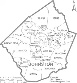
Towns
- Archer Lodge
- Benson
- Clayton
- Four Oaks
- Kenly
- Micro
- Pine Level
- Princeton
- Selma
- Smithfield (county seat)
- Wilson's Mills
Townships
- Banner
- Bentonville
- Beulah
- Boon Hill
- Brogden
- Clayton
- Cleveland
- Elevation
- Ingrams
- Meadow
- Micro
- O'Neals
- Pine Level
- Pleasant Grove
- Selma
- Smithfield
- Wilders
- Wilson Mills
Unincorporated communities
- Allens Crossroads
- Bagley
- Cleveland
- Emit
- Flowers
- Grabtown
- Hocutts Crossroads
- Jordan
- McGee Crossroads
- Peacocks Crossroads
- Powhatan
- Spilona
- Stancils Chapel
- West Smithfield
- Willow Spring (part)
See also
References
- "State & County QuickFacts". United States Census Bureau. Archived from the original on July 13, 2011. Retrieved October 21, 2013.
- "Find a County". National Association of Counties. Archived from the original on May 31, 2011. Retrieved June 7, 2011.
- "Population Estimates 2012 Combined Statistical Areas: April 1, 2010 to July 1, 2012". U.S. Census Bureau. Archived from the original on March 17, 2013. Retrieved March 14, 2013.
- Gannett, Henry (1905). The Origin of Certain Place Names in the United States (Report) (2nd ed.). Washington: Government Printing Office. p. 170 – via United States Geological Survey.
- "2010 Census Gazetteer Files". United States Census Bureau. August 22, 2012. Archived from the original on January 12, 2015. Retrieved January 17, 2015.
- "Population and Housing Unit Estimates". Retrieved March 28, 2020.
- "U.S. Decennial Census". United States Census Bureau. Retrieved January 17, 2015.
- "Historical Census Browser". University of Virginia Library. Retrieved January 17, 2015.
- Forstall, Richard L., ed. (March 27, 1995). "Population of Counties by Decennial Census: 1900 to 1990". United States Census Bureau. Retrieved January 17, 2015.
- "Census 2000 PHC-T-4. Ranking Tables for Counties: 1990 and 2000" (PDF). United States Census Bureau. April 2, 2001. Retrieved January 17, 2015.
- "U.S. Census website". United States Census Bureau. Retrieved January 31, 2008.
- "Scheduled Board Meetings". www.johnstonnc.com. Retrieved March 16, 2018.
- "Meet the Commissioners". www.johnstonnc.com. Retrieved January 9, 2019.
- Leip, David. "Dave Leip's Atlas of U.S. Presidential Elections". uselectionatlas.org. Retrieved March 16, 2018.
- "Johnston Community College". Archived from the original on September 23, 2019. Retrieved February 4, 2020.
- "Archived copy". Archived from the original on February 2, 2017. Retrieved January 26, 2017.CS1 maint: archived copy as title (link)
- "Johnston County Affiliated Libraries". www.jocolib.org. Retrieved March 16, 2018.
- "Clayton Transition Announcement". Mary Duncan Public Library. March 6, 2015. Retrieved March 16, 2018.
- "Johnston County Arts Council". Archived from the original on February 11, 2008. Retrieved January 13, 2008.
- Petey Pablo Raise Up lyrics on Yahoo! Music
Further reading
- Johnston County, North Carolina, Court Martial Minutes, 1761-1779. Transcribed by Weynette Parks Haun (1st ed.). 1983. LCCN 83-244254.CS1 maint: others (link)
- Marriages of Johnston County, North Carolina, 1762-1868. Compiled by Brent H. Holcomb. Baltimore: Genealogical Publishing Co. 1985. ISBN 0-8063-1120-7. LCCN 85-70012.CS1 maint: others (link)
- Sanders, Jr., W. M.; Ragsdale, G. Y. (1922). Johnston County: Economic and Social. University of North Carolina. LCCN 39014760. OCLC 6523398 – via The Smithfield Observer.
External links
| Wikimedia Commons has media related to Johnston County, North Carolina. |
- Government
- General information
- Johnston County Heritage Center, with historical photos, online tours and exhibits, timelines, and facts
- Johnston County Visitors Bureau, the official site for visitor information for Johnston County
Places adjacent to Johnston County, North Carolina | ||||||||||
|---|---|---|---|---|---|---|---|---|---|---|
| ||||||||||
| Authority control |
|---|