Jefferson Davis Parish, Louisiana
Jefferson Davis Parish (French: Paroisse de Jefferson Davis) is a parish located in the U.S. state of Louisiana. As of the 2010 census, the population was 31,594.[1] The parish seat is Jennings.[2] Jefferson Davis Parish is named after the president of the Confederacy during the American Civil War, Jefferson Davis. It is located in southwestern Louisiana and forms a part of the Acadiana region.
Jefferson Davis Parish | |
|---|---|
Parish | |
| Parish of Jefferson Davis | |
 United Methodist Church in Elton. | |
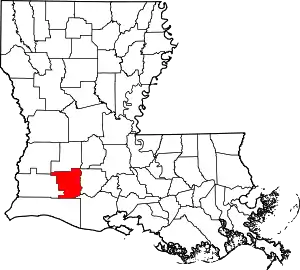 Location within the U.S. state of Louisiana | |
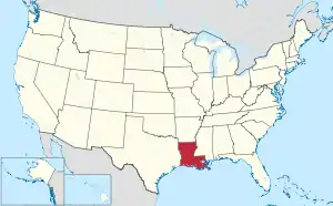 Louisiana's location within the U.S. | |
| Coordinates: 30°14′33″N 92°40′24″W | |
| Country | |
| State | |
| Founded | January 1, 1913 |
| Named for | Jefferson Davis |
| Seat | Jennings |
| Largest city | Jennings |
| Area | |
| • Total | 659 sq mi (1,710 km2) |
| • Land | 651 sq mi (1,690 km2) |
| • Water | 7.2 sq mi (19 km2) 1.1% |
| Population (2010) | |
| • Total | 31,594 |
| • Estimate (2018) | 31,582 |
| • Density | 48/sq mi (19/km2) |
| Time zone | UTC−6 (Central) |
| • Summer (DST) | UTC−5 (CDT) |
| Congressional district | 3rd |
In 2005, the parish was damaged significantly by Hurricane Rita, which caused much wind damage and flooding in the western part of the parish. The storm also caused Lacassine National Wildlife Refuge to be affected by saltwater intrusion.
History
Jefferson Davis Parish was one of the last parishes to be organized in the state of Louisiana. It was originally a part of Imperial Calcasieu Parish, which contributed to five other parishes as the population increased in the area. The bill creating Jefferson Davis Parish was passed by the state legislature in 1912 but did not take effect until 1913.[3] Jefferson Davis Parish is part of the large, 22-county Acadiana region of Louisiana, which is influenced by a large Francophone population. It was named after Jefferson Davis, a prominent planter and the President of the Confederate States of America.
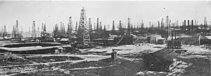
The first oil in Louisiana was drilled in 1901 in Evangeline, Acadia Parish, by W. Scott Heywood, who in 1932 was elected to the Louisiana State Senate.[4] The oil field was known as the Jennings Oil Field because Jennings was the nearest railroad stop to the oil field.
Geography
According to the U.S. Census Bureau, the parish has a total area of 660 square miles (1,700 km2), of which 651 square miles (1,690 km2) is land and 7.2 square miles (19 km2) (1.1%) is water.[5]
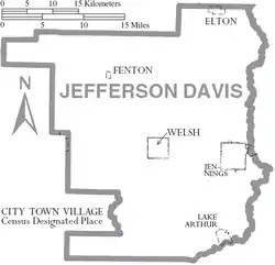
Jefferson Davis Parish comprises five incorporated towns including Elton, Fenton, Jennings, Lake Arthur, and Welsh. There are also many unincorporated areas that add to the interest and economic structure of the parish including Barnsdall, Buller, China, Coverdale, Edna, Fontenot, Foreman's Hall, Hathaway, Illinois Plant, Lacassine, Lauderdale, Panchoville, Pine Island, Raymond, Roanoke, Silverwood, Thornwell, Topsy, Verret, and Woodlawn. Interstate 10 runs east and west through the center of the parish, providing access to local markets. Additionally, the Union Pacific Railroad is centrally located within the parish and the Mermentau River, which connects to the Intracoastal Waterway and has a channel depth of nine feet, provides access to the Port of Mermentau. The Jennings Airport, with a runway length of 5,000 feet (1,500 m), is capable of landing a small jet and is located next to Interstate 10. Jefferson Davis Parish also attracts sportsmen to the Lacassine National Wildlife Refuge.
Adjacent parishes
- Allen Parish (north)
- Evangeline Parish (northeast)
- Acadia Parish (east)
- Vermilion Parish (southeast)
- Cameron Parish (south)
- Calcasieu Parish (west)
- Beauregard Parish (northwest)
Transportation
Major highways
 Interstate 10
 U.S. Highway 90
 U.S. Highway 165
 Louisiana Highway 14
 Louisiana Highway 26
 Louisiana Highway 97
 Louisiana Highway 99
 Louisiana Highway 101
 Louisiana Highway 102
 Louisiana Highway 380
 Louisiana Highway 382
 Louisiana Highway 395
Airports
- Jennings, (3R7)
- Welsh
Jennings, USA | |||||||||||||||||||
|---|---|---|---|---|---|---|---|---|---|---|---|---|---|---|---|---|---|---|---|
| Summary | |||||||||||||||||||
| Airport type | Public | ||||||||||||||||||
| Location | Jennings, LA | ||||||||||||||||||
| Elevation AMSL | 23 ft / 7 m | ||||||||||||||||||
| Coordinates | 30°14′33″N 92°40′24″W | ||||||||||||||||||
| Runways | |||||||||||||||||||
| |||||||||||||||||||
Demographics
| Historical population | |||
|---|---|---|---|
| Census | Pop. | %± | |
| 1920 | 18,999 | — | |
| 1930 | 19,765 | 4.0% | |
| 1940 | 24,191 | 22.4% | |
| 1950 | 26,298 | 8.7% | |
| 1960 | 29,825 | 13.4% | |
| 1970 | 29,554 | −0.9% | |
| 1980 | 32,168 | 8.8% | |
| 1990 | 30,722 | −4.5% | |
| 2000 | 31,435 | 2.3% | |
| 2010 | 31,594 | 0.5% | |
| 2018 (est.) | 31,582 | [6] | 0.0% |
| U.S. Decennial Census[7] 1790-1960[8] 1900-1990[9] 1990-2000[10] 2010-2013[1] | |||
As of the census[11] of 2000, there were 31,435 people, 11,480 households, and 8,529 families residing in the parish. The population density was 48 people per square mile (19/km2). There were 12,824 housing units at an average density of 20 per square mile (8/km2). The racial makeup of the parish was 80.60% White, 17.79% Black or African American, 0.38% Native American, 0.19% Asian, 0.01% Pacific Islander, 0.20% from other races, and 0.82% from two or more races. 0.99% of the population were Hispanic or Latino of any race. 16.15% of the population reported speaking French or Cajun French at home.
There were 11,480 households, out of which 37.20% had children under the age of 18 living with them, 56.80% were married couples living together, 13.70% had a female householder with no husband present, and 25.70% were non-families. 22.60% of all households were made up of individuals, and 10.70% had someone living alone who was 65 years of age or older. The average household size was 2.70 and the average family size was 3.18.
In the parish the population was spread out, with 29.30% under the age of 18, 9.10% from 18 to 24, 27.30% from 25 to 44, 21.00% from 45 to 64, and 13.30% who were 65 years of age or older. The median age was 34 years. For every 100 females there were 92.50 males. For every 100 females age 18 and over, there were 87.50 males.
The median income for a household in the parish was $27,736, and the median income for a family was $33,129. Males had a median income of $28,279 versus $18,668 for females. The per capita income for the parish was $13,398. About 18.10% of families and 20.90% of the population were below the poverty line, including 25.40% of those under age 18 and 19.90% of those age 65 or over.
Education
Jefferson Davis Parish Public Schools operates the schools in the parish.
- Elton Elementary School (Grades PK-5) (Elton)
- Elton High School (Grades 6-12) (Elton)
- Fenton Elementary School (Grades PK-8) (Fenton)
- Hathaway High School (Grades K-12) (Jennings)
- Jennings Elementary School (Grades 3-6) (Jennings)
- Jennings High School (Grades 7-12) (Jennings)
- Lacassine High School (Grades K-12) (Lacassine)
- Lake Arthur Elementary School (Grades PK-6) (Lake Arthur)
- Lake Arthur High School (Grades 7-12) (Lake Arthur)
- James Ward Elementary School (Grades PK-2) (Jennings)
- Welsh Elementary School (Grades PK-5) (Welsh)
- Welsh High School (Grades 8-12) (Welsh)
- Welsh-Roanoke Jr. High School (Grades 6-8) (Roanoke)
Jeff Davis Parish is served by the Roman Catholic Diocese of Lafayette which has one school in the parish:
- Our Lady Immaculate (Grades PK-8) (Jennings)
Additionally, Jeff Davis is served by one unaffiliated private school
- Bethel Christian School is a PreK-12 Christian school located in unincorporated Jefferson Davis Parish, near Jennings.[12]
Jeff Davis Parish is served by one institution of higher education
- The Morgan Smith campus of the Sowela Technical Community College is located in Jennings.
National Guard
C Company 3-156TH Infantry Battalion resides in Jennings, Louisiana. This unit as part of the 256th IBCT deployed twice to Iraq in 2004-5 and 2010.
Communities
City
- Jennings (parish seat and largest municipality)
Towns
Village
Notable people
- A.C. Clemons
- Al Woods
- Thomas A. "Tom" Greene
- John E. Guinn
- Charles Franklin Hildebrand
- Dan Morrish
- Claude Kirkpatrick
- Edith Killgore Kirkpatrick
- Guy Sockrider
- Gerald Theunissen
- Bernard N. Marcantel, District Attorney and City Judge of Jennings and Ward II.
Politics
| Year | Republican | Democratic | Third parties |
|---|---|---|---|
| 2020 | 77.0% 11,423 | 21.6% 3,208 | 1.4% 210 |
| 2016 | 75.5% 10,775 | 21.6% 3,080 | 3.0% 422 |
| 2012 | 72.9% 10,014 | 25.4% 3,484 | 1.7% 236 |
| 2008 | 68.7% 9,278 | 29.1% 3,923 | 2.2% 300 |
| 2004 | 61.9% 8,055 | 36.5% 4,745 | 1.6% 207 |
| 2000 | 55.4% 6,945 | 41.1% 5,162 | 3.5% 439 |
| 1996 | 33.3% 4,311 | 53.3% 6,897 | 13.4% 1,735 |
| 1992 | 32.6% 4,513 | 50.7% 7,022 | 16.6% 2,303 |
| 1988 | 45.7% 5,851 | 53.2% 6,799 | 1.1% 141 |
| 1984 | 57.4% 8,296 | 41.2% 5,962 | 1.4% 206 |
| 1980 | 46.7% 5,667 | 50.6% 6,140 | 2.6% 320 |
| 1976 | 35.1% 3,603 | 62.0% 6,376 | 2.9% 299 |
| 1972 | 66.0% 5,903 | 28.5% 2,551 | 5.5% 495 |
| 1968 | 22.7% 2,213 | 27.1% 2,641 | 50.2% 4,897 |
| 1964 | 42.5% 3,673 | 57.5% 4,966 | 0.0% 0 |
| 1960 | 25.8% 2,251 | 67.8% 5,904 | 6.4% 557 |
| 1956 | 62.9% 4,170 | 35.4% 2,346 | 1.7% 110 |
| 1952 | 49.0% 3,447 | 51.0% 3,584 | 0.0% 0 |
| 1948 | 21.8% 793 | 47.2% 1,717 | 31.1% 1,131 |
| 1944 | 33.2% 1,156 | 66.8% 2,329 | 0.0% 0 |
| 1940 | 29.4% 1,054 | 70.6% 2,531 | 0.0% 0 |
| 1936 | 19.2% 608 | 80.9% 2,567 | 0.0% 0 |
| 1932 | 18.1% 512 | 81.7% 2,308 | 0.1% 4 |
| 1928 | 39.7% 1,120 | 60.3% 1,703 | 0.0% 0 |
| 1924 | 47.6% 883 | 52.4% 973 | 0.0% 0 |
| 1920 | 55.1% 895 | 44.9% 728 | 0.0% 0 |
| 1916 | 22.9% 200 | 75.1% 656 | 2.0% 17 |
See also
- Jeff Davis 8 string of unsolved murders
- National Register of Historic Places listings in Jefferson Davis Parish, Louisiana
References
- "State & County QuickFacts". United States Census Bureau. Archived from the original on June 19, 2011. Retrieved August 9, 2013.
- "Find a County". National Association of Counties. Archived from the original on 2011-05-31. Retrieved 2011-06-07.
- Gremillion, John Berton Gremillion. "Jefferson Davis Parish". http://library.mcneese.edu. McNeese State University. Archived from the original on March 27, 2015. Retrieved September 4, 2014. External link in
|website=(help) - "Heywood, Walter Scott". Louisiana Historical Association, A Dictionary of Louisiana Biography. Archived from the original on February 25, 2010. Retrieved January 30, 2011.
- "2010 Census Gazetteer Files". United States Census Bureau. August 22, 2012. Archived from the original on September 28, 2013. Retrieved September 1, 2014.
- "Population and Housing Unit Estimates". Retrieved October 29, 2019.
- "U.S. Decennial Census". United States Census Bureau. Retrieved September 1, 2014.
- "Historical Census Browser". University of Virginia Library. Retrieved September 1, 2014.
- "Population of Counties by Decennial Census: 1900 to 1990". United States Census Bureau. Retrieved September 1, 2014.
- "Census 2000 PHC-T-4. Ranking Tables for Counties: 1990 and 2000" (PDF). United States Census Bureau. Retrieved September 1, 2014.
- "U.S. Census website". United States Census Bureau. Retrieved 2008-01-31.
- "Contact Information." Bethel Christian School. Retrieved on November 26, 2012. "15147 Hwy 102 Jennings, LA 70546"
- Leip, David. "Dave Leip's Atlas of U.S. Presidential Elections". uselectionatlas.org.
External links
- Jefferson Davis Parish Sheriff's Office
- Jefferson Davis Parish Economic Development & Tourist Commission
Geology
- Heinrich, P. V., J. Snead, and R. P. McCulloh, 2002, Lake Charles 30 x 60 minute geologic quadrangle. Louisiana Geological Survey, Baton Rouge, Louisiana.
- Heinrich, P. V., J. Snead, and R. P. McCulloh, 2003, Crowley 30 x 60 minute geologic quadrangle. Louisiana Geological Survey, Baton Rouge, Louisiana.
Hydrology
Municipalities and communities of Jefferson Davis Parish, Louisiana, United States | ||
|---|---|---|
| Cities | | |
| Towns | ||
| Villages | ||
| CDPs | ||
| Other unincorporated communities | ||
| Indian reservation | ||
| Footnotes | ‡This populated place also has portions in an adjacent county or counties | |
| ||
| Authority control |
|---|