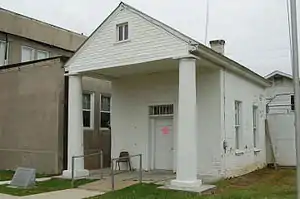
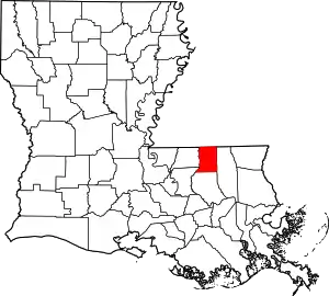
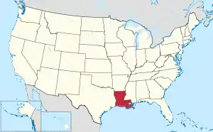
St. Helena Parish, Louisiana
St. Helena Parish (French: Paroisse de Sainte-Hélène) is a parish in the U.S. state of Louisiana. As of the 2010 census, the population was 11,203.[1] Its seat is Greensburg.[2] The parish was created in 1810.[3]
Saint Helena Parish | |
|---|---|
Parish | |
| Parish of St. Helena | |
 | |
 Location within the U.S. state of Louisiana | |
 Louisiana's location within the U.S. | |
| Coordinates: 30°49′N 90°43′W | |
| Country | |
| State | |
| Founded | 1810 |
| Named for | Saint Helena |
| Seat | Greensburg |
| Largest town | Greensburg |
| Area | |
| • Total | 409 sq mi (1,060 km2) |
| • Land | 408 sq mi (1,060 km2) |
| • Water | 1.1 sq mi (3 km2) 0.3% |
| Population (2010) | |
| • Total | 11,203 |
| • Estimate (2018) | 10,262 |
| • Density | 27/sq mi (11/km2) |
| Time zone | UTC−6 (Central) |
| • Summer (DST) | UTC−5 (CDT) |
| Congressional districts | 5th, 6th |
| Website | sthelenaparish |
St. Helena Parish is part of the Baton Rouge, LA Metropolitan Statistical Area.
History
The parish is one of the eight Florida Parishes, a region which was once part of colonial West Florida. The area was annexed to the Territory of Orleans in 1810, after the short-lived Republic of West Florida capitulated to the United States.
In 1832, the southern section of the parish was taken to form Livingston Parish; the courthouse was moved from Montpelier to Greensburg, where it remains today. St. Helena lost another portion of land in 1866, which was subsequently added to land from other parishes to form Tangipahoa Parish.
From 1964 to 1984, St. Helena Parish was represented in the Louisiana State Senate by the Democrat businessman W. E. "Bill" Dykes. In 1983, as a casualty of redistricting, Dykes bowed out of contention in a race which would have pitted him against long-term Senate President Sixty Rayburn of Bogalusa, Louisiana.
In recent years, St. Helena experienced a series of scandals involving parish officials. In 1997, Sheriff Eugene Holland was found guilty of misuse of government funds and property and using prison inmates for personal labor. His replacement, Chaney L. Phillips (born c. 1950), served for only a year as sheriff before he was convicted of fraud and money laundering that he had committed while serving as the parish assessor. He was given an eight-year prison sentence on conviction in 1998 of having placed a political supporter on his assessor office staff; the individual performed no duties. Phillips was assigned to the Federal Correctional Institution in Englewood, Colorado.[4] He did not serve the full eight years; he was released on May 23, 2003.[5]
Ronald "Gun" Ficklin took over the sheriff's office from Phillips in 1998, but on February 5, 2007, Ficklin himself pleaded guilty on multiple counts involving his role in operating "chop shops" — reselling stolen automobiles and parts — using state prisoners to staff these activities and as a pit crew for his race car.[6][7]
In 2007, Nat Williams was elected as Ficklin's replacement.
Geography
According to the U.S. Census Bureau, the parish has a total area of 409 square miles (1,060 km2), of which 408 square miles (1,060 km2) is land and 1.1 square miles (2.8 km2) (0.3%) is water.[8]
Major highways
 Louisiana Highway 10
 Louisiana Highway 16
 Louisiana Highway 37
 Louisiana Highway 38
 Louisiana Highway 43
 Louisiana Highway 441
Adjacent parishes and counties
- Amite County, Mississippi (north)
- Tangipahoa Parish (east)
- Livingston Parish (south)
- East Baton Rouge Parish (southwest)
- East Feliciana Parish (west)
Demographics
| Historical population | |||
|---|---|---|---|
| Census | Pop. | %± | |
| 1820 | 3,026 | — | |
| 1830 | 4,028 | 33.1% | |
| 1840 | 3,525 | −12.5% | |
| 1850 | 4,561 | 29.4% | |
| 1860 | 7,130 | 56.3% | |
| 1870 | 5,423 | −23.9% | |
| 1880 | 7,504 | 38.4% | |
| 1890 | 8,062 | 7.4% | |
| 1900 | 8,479 | 5.2% | |
| 1910 | 9,172 | 8.2% | |
| 1920 | 8,427 | −8.1% | |
| 1930 | 8,492 | 0.8% | |
| 1940 | 9,542 | 12.4% | |
| 1950 | 9,013 | −5.5% | |
| 1960 | 9,162 | 1.7% | |
| 1970 | 9,937 | 8.5% | |
| 1980 | 9,827 | −1.1% | |
| 1990 | 9,874 | 0.5% | |
| 2000 | 10,525 | 6.6% | |
| 2010 | 11,203 | 6.4% | |
| 2018 (est.) | 10,262 | [9] | −8.4% |
| U.S. Decennial Census[10] 1790-1960[11] 1900-1990[12] 1990-2000[13] 2010-2013[1] | |||
As of the 2010 United States Census, there were 11,203 people living in the parish. 53.3% were Black or African American, 44.9% White, 0.3% Native American, 0.1% Asian, 0.5% of some other race and 0.8% of two or more races. 0.9% were Hispanic or Latino (of any race).
As of 2000, there were 10,525 people, 3,873 households, and 2,784 families living in the parish. The population density was 10/km2 (26/mi2). There were 5,034 housing units at an average density of 5 persons/km2 (12 persons/mi2). The racial makeup of the parish was 52.42% Black or African American, 46.53% White, 0.10% Native American, 0.10% Asian, 0.01% Pacific Islander, 0.14% from other races, and 0.71% from two or more races. 0.99% of the population were Hispanic or Latino of any race.
There were 3,873 households, out of which 34.00% had children under the age of 18 living with them, 48.90% were married couples living together, 18.40% had a female householder with no husband present, and 28.10% were non-families. 25.40% of all households were made up of individuals, and 10.40% had someone living alone who was 65 years of age or older. The average household size was 2.70 and the average family size was 3.27.
In the parish, the population was spread out, with 29.00% under the age of 18, 9.10% from 18 to 24, 26.10% from 25 to 44, 23.30% from 45 to 64, and 12.50% who were 65 years of age or older. The median age was 35 years. For every 100 females, there were 92.40 males. For every 100 females age 18 and over, there were 87.60 males.
The median income for a household in the parish was $24,970, and the median income for a family was $29,950. Males had a median income of $30,218 versus $16,853 for females. The per capita income for the parish was $12,318. About 22.80% of families and 26.80% of the population were below the poverty line, including 35.50% of those under age 18 and 23.20% of those age 65 or over.
Education
The Elementary and High School in St. Helena Parish are part of the St. Helena Parish School System. The Middle School in St. Helena Parish is part of the Recovery School District of Louisiana.
Communities
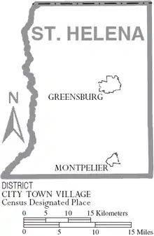
Town
- Greensburg (parish seat and largest municipality)
Village
Unincorporated communities
Brushy Creek Crater
St. Helena Parish contains the only meteorite impact crater reported from the state of Louisiana. This suspected impact crater is a roughly circular depression about 1.2 miles/2 km in diameter. Shocked quartz and intensely fractured quartz have been recovered from fractured and possibly altered sediments comprising its rim. Its age is estimated to be between 11 and 30 ka.[14] It lies about 5.8 miles/9.3 kilometers southwest of Greensburg, in the southwest corner of the parish. Louisiana Highway 37 cuts through the northern edge of this feature.[14][15][16]
Politics
| Year | Republican | Democratic | Third parties |
|---|---|---|---|
| 2020 | 44.1% 2,714 | 54.3% 3,346 | 1.6% 98 |
| 2016 | 41.9% 2,497 | 56.2% 3,353 | 1.9% 114 |
| 2012 | 39.6% 2,529 | 59.1% 3,780 | 1.3% 85 |
| 2008 | 40.8% 2,522 | 57.7% 3,567 | 1.5% 95 |
| 2004 | 40.6% 2,235 | 57.6% 3,173 | 1.8% 100 |
| 2000 | 37.4% 1,965 | 58.2% 3,059 | 4.4% 230 |
| 1996 | 26.0% 1,455 | 65.8% 3,692 | 8.2% 461 |
| 1992 | 27.0% 1,515 | 60.8% 3,416 | 12.2% 687 |
| 1988 | 38.9% 2,006 | 58.5% 3,013 | 2.6% 134 |
| 1984 | 43.5% 2,366 | 54.4% 2,956 | 2.1% 113 |
| 1980 | 31.6% 1,531 | 65.6% 3,183 | 2.9% 138 |
| 1976 | 27.6% 1,046 | 69.2% 2,622 | 3.2% 120 |
| 1972 | 52.0% 1,446 | 33.9% 943 | 14.1% 392 |
| 1968 | 6.5% 219 | 40.1% 1,351 | 53.4% 1,800 |
| 1964 | 65.1% 1,319 | 34.9% 706 | |
| 1960 | 16.4% 296 | 37.5% 678 | 46.2% 835 |
| 1956 | 32.3% 545 | 59.0% 997 | 8.7% 147 |
| 1952 | 39.6% 586 | 60.4% 895 | |
| 1948 | 5.0% 59 | 39.4% 469 | 55.7% 663 |
| 1944 | 13.7% 108 | 86.4% 683 | |
| 1940 | 7.4% 80 | 92.6% 1,007 | |
| 1936 | 7.8% 102 | 92.2% 1,199 | |
| 1932 | 2.6% 26 | 97.4% 962 | |
| 1928 | 19.2% 145 | 80.8% 609 | |
| 1924 | 8.9% 18 | 91.1% 185 | |
| 1920 | 9.0% 36 | 91.0% 366 | |
| 1916 | 2.7% 9 | 95.5% 319 | 1.8% 6 |
| 1912 | 5.4% 13 | 88.8% 214 | 5.8% 14 |
See also
References
- "State & County QuickFacts". United States Census Bureau. Retrieved August 18, 2013.
- "Find a County". National Association of Counties. Archived from the original on May 31, 2011. Retrieved June 7, 2011.←Broken link December 2015.
- "St. Helena Parish". Center for Cultural and Eco-Tourism. Retrieved September 6, 2014.
- "ES&S, Diebold lobbyists". bbvforums.org. Archived from the original on October 2, 2013. Retrieved June 26, 2013.
- "Chaney L. Phillips". bop.gov. Retrieved June 26, 2013.
- Brown, Penny (February 5, 2007). "St. Helena sheriff pleads guilty to role in illegal chop shop". The Advocate. Baton Rouge. Archived from the original on February 8, 2007. Retrieved February 6, 2007.
- "Sheriff pleads guilty in chop shop case". Associated Press (via Yahoo! News). February 6, 2007. Retrieved February 6, 2007.
- "2010 Census Gazetteer Files". United States Census Bureau. August 22, 2012. Archived from the original on September 28, 2013. Retrieved September 1, 2014.
- "Population and Housing Unit Estimates". Retrieved October 27, 2019.
- "U.S. Decennial Census". United States Census Bureau. Archived from the original on April 26, 2015. Retrieved September 1, 2014.
- "Historical Census Browser". University of Virginia Library. Retrieved September 1, 2014.
- "Population of Counties by Decennial Census: 1900 to 1990". United States Census Bureau. Retrieved September 1, 2014.
- "Census 2000 PHC-T-4. Ranking Tables for Counties: 1990 and 2000" (PDF). United States Census Bureau. Retrieved September 1, 2014.
- Heinrich, P.V. (2003) Possible Meteorite Impact Crater in St. Helena Parish, Louisiana. Search and Discovery Article. no. 50006. American Association of Petroleum Geologist, Tulsa, Oklahoma. Retrieved 2011-27-03.
- Heinrich, P.V. (2003) Origin of a Circular Depression and Associated Fractured and Shocked Quartz, St. Helena Parish, LA. Transactions of the Gulf Association of Geological Societies. vol. 53, pp. 313-322.
- LGS Researcher Featured in Meteor Crater News Story. Archived March 21, 2012, at the Wayback Machine Center for Energy Studies, Louisiana State University Baton Rouge. Retrieved 2011-27-03.
- Leip, David. "Dave Leip's Atlas of U.S. Presidential Elections". uselectionatlas.org. Retrieved March 8, 2018.
External links
- St Helena Parish Police Jury
- Explore the History and Culture of Southeastern Louisiana at National Park Service
Places adjacent to St. Helena Parish, Louisiana | ||||||||||
|---|---|---|---|---|---|---|---|---|---|---|
| ||||||||||
Municipalities and communities of St. Helena Parish, Louisiana, United States | ||
|---|---|---|
| Town | | |
| Village | ||
| Unincorporated community | ||
| ||
| Authority control |
|---|